
Grain Fort is a former artillery fort located just east of the village of Grain, Kent. It was constructed in the 1860s to defend the confluence of the Rivers Medway and Thames during a period of tension with France. The fort's location enabled its guns to support the nearby Grain Tower and Garrison Point Fort at Sheerness on the other side of the Medway. It was repeatedly altered and its guns upgraded at various points in its history, before being decommissioned in 1956 when the UK abolished its coastal defence programme. It was subsequently demolished. The remnants of the fort are still visible and have been incorporated into a coastal park.

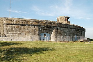
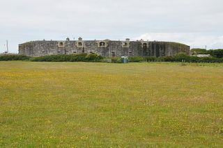
Garrison Point Fort is a former artillery fort situated at the end of the Garrison Point peninsula at Sheerness on the Isle of Sheppey in Kent. Built in the 1860s in response to concerns about a possible French invasion, it was the last in a series of artillery batteries that had existed on the site since the mid-16th century. The fort's position enabled it to guard the strategic point where the River Medway meets the Thames. It is a rare example of a two-tiered casemated fort – one of only two of that era in the country – with a design that is otherwise similar to that of several of the other forts along the lower Thames. It remained operational until 1956 and is now used by the Sheerness Docks as a port installation.

New Tavern Fort is an historic artillery fort in Gravesend, Kent. Dating mostly from the 18th and 19th centuries, it is an unusually well-preserved example of an 18th-century fortification and remained in use for defensive purposes until the Second World War. It was built during the American War of Independence to guard the Thames against French and Spanish raiders operating in support of the newly formed United States of America. It was redesigned and rebuilt in the mid-19th century to defend against a new generation of iron-clad French warships.

Shornemead Fort is a now-disused artillery fort that was built in the 1860s to guard the entrance to the Thames from seaborne attack. Constructed during a period of tension with France, it stands on the south bank of the river at a point where the Thames curves sharply north and west, giving the fort long views up and downriver in both directions. It was the third fort constructed on the site since the 18th century, but its location on marshy ground led to major problems with subsidence. The fort was equipped for a time with a variety of large-calibre artillery guns which were intended to support two other nearby Thamesside forts. However, the extent of the subsidence meant that it became unsafe for the guns to be fired and the fort was disarmed by the early 20th century.
Coalhouse Fort is an artillery fort in the eastern English county of Essex. It was built in the 1860s to guard the lower Thames from seaborne attack. It stands at Coalhouse Point on the north bank of the river, at a location near East Tilbury which was vulnerable to raiders and invaders. It was the last in a series of fortifications dating back to the 15th century and was the direct successor to a smaller mid-19th century fort built on the same site. Constructed during a period of tension with France, its location on marshy ground caused problems from the start and led to a lengthy construction process. The fort was equipped with a variety of large-calibre artillery guns and the most modern defensive facilities of the time, including shell-proof casemates protected by granite facing and cast-iron shields. Its lengthy construction and the rapid pace of artillery development at the time meant that it was practically obsolete for its original purpose within a few years of its completion.

Fort Gilkicker is a historic Palmerston fort built at the eastern end of Stokes Bay, Gosport, Hampshire to dominate the key anchorage of Spithead. It was erected between 1863 and 1871 as a semi-circular arc with 22 casemates, to be armed with five twelve-inch guns, seventeen ten-inch guns and five nine-inch guns. The actual installed armament rather differed from this. In 1902 the RML guns were replaced by two 9.2-inch and two six-inch BL guns, and before the First World War the walls were further strengthened with substantial earthwork embankments. The fort was disarmed in 1956 and used for storage until 1999, and is currently in a state of disrepair.

Fort Fareham is one of the Palmerston Forts, in Fareham, England. After the Gosport Advanced Line of Fort Brockhurst, Fort Elson, Fort Rowner, Fort Grange and Fort Gomer had been approved by the Royal Commission on the Defence of the United Kingdom a decision was made to build an outer line of three more forts two miles in advance of the Gosport Advanced Line. Of these three projected forts only Fort Fareham was built due to the need to cut costs. It acted as a hinge between the forts on Portsdown Hill and those of the Gosport Advanced Line, filling the gap at Fareham. It has been a Grade II Listed Building since 1976.

Several boards have been appointed by US presidents or Congress to evaluate the US defensive fortifications, primarily coastal defenses near strategically important harbors on the US shores, its territories, and its protectorates.

A disappearing gun, a gun mounted on a disappearing carriage, is an obsolete type of artillery which enabled a gun to hide from direct fire and observation. The overwhelming majority of carriage designs enabled the gun to rotate backwards and down behind a parapet, or into a pit protected by a wall after it was fired; a small number were simply barbette mounts on a retractable platform. Either way, retraction lowered the gun from view and direct fire by the enemy while it was being reloaded. It also made reloading easier, since it lowered the breech to a level just above the loading platform, and shells could be rolled right up to the open breech for loading and ramming. Other benefits over non-disappearing types were a higher rate of repetitive fire and less fatigue for the gun crew.
Tregantle Fort in south east Cornwall is one of several forts surrounding Plymouth that were built as a result of a decision in Lord Palmerston's premiership to deter the French from attacking naval bases on the Channel coast.

Cliffe Fort is a disused artillery fort built in the 1860s to guard the entrance to the Thames from seaborne attack. Constructed during a period of tension with France, it stands on the south bank of the river at the entrance to Cliffe Creek in the Cliffe marshes on the Hoo Peninsula in North Kent. Its location on marshy ground caused problems from the start and necessitated changes to its design after the structure begin to crack and subside during construction. The fort was equipped with a variety of large-calibre artillery guns which were intended to support two other nearby Thamesside forts. A launcher for the Brennan torpedo—which has been described as the world's first practical guided missile—was installed there at the end of the 19th century but was only in active use for a few years.

The BL 6-inch gun Mark VII was a British naval gun dating from 1899, which was mounted on a heavy traveling carriage in 1915 for British Army service to become one of the main heavy field guns in the First World War, and also served as one of the main coast defence guns throughout the British Empire until the 1950s.
The Ben Buckler Gun Battery is a heritage-listed fortified former gun emplacement and military installation of the late-Victorian period and now public open space located in the North Bondi locality of Ben Buckler, in the Waverley Municipality of Sydney, New South Wales, Australia. The gun battery was designed by NSW Colonial Government and built during 1893. It is also known as Ben Buckler Gun Battery 1893, 9.2 Disappearing Gun and Bondi Battery. The property is owned by Waverley Municipal Council. It was added to the New South Wales State Heritage Register on 15 December 2006.
Yaverland Battery is a battery on the Isle of Wight, United Kingdom. It was constructed between 1861 and 1864.
The Armstrong RBL 40-pounder gun was introduced into use in 1860 for service on both land and sea. It used William Armstrong's new and innovative rifled breechloading mechanism. It remained in use until 1902 when replaced by more modern Breech Loading (BL) guns.

Fort Ballance is a former coastal artillery battery on Point Gordon on Wellington's Miramar Peninsula.

Grain Tower is a mid-19th-century gun tower situated offshore just east of Grain, Kent, standing in the mouth of the River Medway. It was built along the same lines as the Martello towers that were constructed along the British and Irish coastlines in the early 19th century and is the last-built example of a gun tower of this type. It owed its existence to the need to protect the important dockyards at Sheerness and Chatham from a perceived French naval threat during a period of tension in the 1850s.

The 12-inch coastal defense gun M1895 (305 mm) and its variants the M1888 and M1900 were large coastal artillery pieces installed to defend major American seaports between 1895 and 1945. For most of their history they were operated by the United States Army Coast Artillery Corps. Most were installed on disappearing carriages, with early installations on low-angle barbette mountings. From 1919, 19 long-range two-gun batteries were built using the M1895 on an M1917 long-range barbette carriage. Almost all of the weapons not in the Philippines were scrapped during and after World War II.
Grain Wing Battery is a former gun battery located just east of the village of Grain, Kent at the confluence of the Rivers Thames and Medway. It supported two existing and adjacent artillery batteries at Grain Fort and Dummy Battery, overlapping its arc of fire with Grain Tower just offshore and with Garrison Point Fort on the Isle of Sheppey across the other side of the Medway. The battery consisted of an earthwork with several gun emplacements. It was only in use as a battery for a few years after its completion in 1895, though its interior continued to be occupied by Army buildings. It was abandoned in 1956 and its remains were demolished and infilled a few years later. The site is now part of a coastal park owned by the local council.

Dummy Battery, originally known as Grain Battery, is a disused fortified gun battery located about 1 kilometre (0.62 mi) south of the village of Grain, Kent at the confluence of the Rivers Thames and Medway. Completed in 1865, it supported two nearby coast artillery batteries at Grain Fort and Grain Wing Battery, a short distance to the north. The battery's arc of fire overlapped with Grain Tower just offshore and with Garrison Point Fort on the Isle of Sheppey across the other side of the Medway. It consisted of an earthwork with a concrete core supporting several gun emplacements with magazines below. It appears to have gone out of service as a battery by the time of the First World War, though it briefly took on a role in anti-aircraft defence. It was subsequently abandoned and was severely damaged by demolitions and the removal of its earthworks, leaving only the substantial remains of its concrete core standing today.
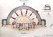 Ground plan of Slough Fort showing interior layout
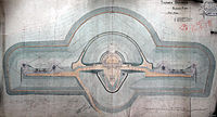 Top plan of Slough Fort showing layout of main fort (centre) and wing batteries


