Smyer, Texas

Last updated

Smyer, Texas
Polish 20230510 235816991.jpg
The town of Smyer in 1925, picture taken from current Lincoln St.
Relief map of Texas.png
Red pog.svg
Smyer
Coordinates: 33°35′03″N102°09′48″W / 33.58417°N 102.16333°W / 33.58417; -102.16333 [1]
CountryFlag of the United States.svg  United States
StateFlag of Texas.svg  Texas
County Hockley
Region Llano Estacado
Established1924
Incorporated1963
Founded byClinton E. Smyer (1871-1957)
Area
[2]
  Total0.80 sq mi (2.06 km2)
  Land0.80 sq mi (2.06 km2)
  Water0.00 sq mi (0.00 km2)
Elevation
[1]
3,389 ft (1,033 m)
Population
 (2010)
  Total474
  Estimate 
(2022) [3]
433
  Density599.75/sq mi (231.63/km2)
Time zone UTC-6 (CST)
ZIP code
79367
Area code 806
FIPS code 48-68504
GNIS feature ID1368526
Website https://www.smyer-isd.org

Smyer is a town in Hockley County, Texas, United States. It is located near the Old Spade Ranch House where the current ranch headquarters is. The population was 474 at the 2010 census. [4] in 2023, the population declined to 433.

Contents

History

Smyer was settled in 1917, when William L. Ellwood began selling portions of the Spade Ranch to farmers. The town was founded in 1924 and deemed platted in 1925 after construction was completed, which soon opened up the rail service to begin in Smyer when the Santa Fe ran railroad beside the townsite. The town had many things to offer as a small town such as a school, a gin, two stores, a railway depot, and a lumberyard. The school district was created in 1924 and organized in 1927 as the old school board and new board consolidated to form the present-day school board. In 1929, the town was hit by a heavy tornado and it destroyed many things in Smyer, but the farmers managed to get back up and rebuilt from the ground up and made it better. In 1951, a new elementary school was built and in 1957, newer additions of the buildings were made to improve the student's time in school. In 1963, Smyer decided that with new plans for a school building, they would create and established a government body in the town and soon enough incorporated the same year. In 1980, the population was 455, and in 2000, the population was 480, the largest peak population ever in Smyer. In 2020, Smyer remodeled, rebuilt, and sold different areas and certain criteria around the town's functions. The town is predicted to grow in the coming years as western Lubbock continues to grow and impact other areas such as Ropesville.

Smyer Santa Fe Depot

In 1925, a brick depot was constructed be the Santa Fe to serve as a midway between the towns of Levelland and Lubbock. Clinton E. Smyer, a railroad superintendent, wanted a town of his own since other people from the railway company were able to get approval for their own railroad towns. The town was given a depot to serve its area and ship the farmers’ crops and other supplies to Lubbock to be hauled onto mainlines in the other parts of Texas. The depot was an updated version from the 1895 variant to the newer style common for the time. The depot served Smyer as the South Plains & Santa Fe Railroad and made large vast trips to father areas across the South Plains. When the SP&SF eventually consolidated and ceased in the later years, the depot in Smyer was of no use until it was converted into a residence and was updated into its current status. The depot is alongside the road to the new gas station in Smyer, and has a red brick look to it with some modifications such as modern woodwork and other things. The depot is currently still in use as a residential property.

Geography

Smyer is located on the high plains of the Llano Estacado at 33°35′03″N102°09′48″W / 33.58417°N 102.16333°W / 33.58417; -102.16333 (33.5842563, –102.1632291), [5] in eastern Hockley County. Texas State Highway 114 passes through the southern side of the town, leading west 16 miles (26 km) to Levelland, the county seat, and east 17 miles (27 km) to Lubbock.

According to the United States Census Bureau, Smyer has a total area of 0.81 square miles (2.1 km2), all land. [4]

Demographics

Historical population
CensusPop.Note
1930 102
1940 12522.5%
1950 22983.2%
1960 25812.7%
1970 2652.7%
1980 45571.7%
1990 442−2.9%
2000 4808.6%
2010 474−1.2%
2020 4801.3%
2022 (est.)433 [3] −9.8%
U.S. Decennial Census [6]

As of the census [7] of 2020, 481 people, 187 households, and 152 families resided in the town. The population density was 617.3 inhabitants per square mile (238.3/km2). The 215 housing units averaged 276.5 per square mile (106.4/km2). The racial makeup of the town was 81.88% White, 2.08% African American, 1.25% Native American, 13.12% from other races, and 1.67% from two or more races. Hispanics or Latinos of any race were 29.17% of the population.

Of the 187 households, 39.1% had children under the age of 18 living with them, 55.9% were married couples living together, 17.9% had a female householder with no husband present, and 20.7% were not families. About 19.6% of all households were made up of individuals, and 10.1% had someone living alone who was 65 years of age or older. The average household size was 2.68 and the average family size was 3.04.

In the town, the population was distributed as 32.1% under the age of 18, 6.0% from 18 to 24, 27.3% from 25 to 44, 21.9% from 45 to 64, and 12.7% who were 65 years of age or older. The median age was 37 years. For every 100 females, there were 94.3 males. For every 100 females age 18 and over, there were 84.2 males.

The median income for a household in the town was $30,667, and for a family was $32,000. Males had a median income of $23,594 versus $20,313 for females. The per capita income for the town was $11,784. About 16.4% of families and 17.3% of the population were below the poverty line, including 26.9% of those under age 18 and 3.8% of those age 65 or over.

Education

The town is served by the Smyer Independent School District. The Principal of the Elementary School is Mr. Pond. The Principal of the High School is Mr. Schaap, and the Superintendent of Smyer is Mr. Chris Wade

See also

Related Research Articles

<span class="mw-page-title-main">Lynn County, Texas</span> County in Texas, United States

Lynn County is a county in the U.S. state of Texas. As of the 2020 census, its population was 5,596. Its county seat is Tahoka. The county was created in 1876 and organized in 1903.

<span class="mw-page-title-main">Lubbock County, Texas</span> County in Texas, United States

Lubbock County is a county located in the U.S. state of Texas. The 2020 census placed the population at 310,639. Its county seat and largest city is Lubbock. The county was created in 1876 and organized in 1891. It is named for Thomas Saltus Lubbock, a Confederate colonel and Texas Ranger.

<span class="mw-page-title-main">Hockley County, Texas</span> County in Texas, United States

Hockley County is a county located in the U.S. state of Texas. As of the 2020 census, its population was 21,537. Its county seat is Levelland. The county was created in 1876, but not organized until 1921. It is named for George Washington Hockley, a secretary of war of the Republic of Texas.

<span class="mw-page-title-main">Crosby County, Texas</span> County in Texas, United States

Crosby County is a county located in the U.S. state of Texas. As of the 2020 census, its population was 5,133. The county seat is Crosbyton. The county was founded in 1876 and later organized in 1886. Both the county and its seat are named for Stephen Crosby, a land commissioner in Texas.

<span class="mw-page-title-main">Morton, Texas</span> City in Texas, United States

Morton is a city in and the county seat of Cochran County, Texas, United States. As of the 2020 census, the city population was 1,690. This represented a 15.8% population decline since the 2010 Census.

<span class="mw-page-title-main">Whiteface, Texas</span> Community in Texas, United States

Whiteface is a town in Cochran County, Texas, United States. The population was 449 at the 2010 census.

<span class="mw-page-title-main">Anton, Texas</span> City in Texas, United States

Anton is a city in Hockley County, Texas, United States. The population was 1,126 at the 2010 census.

<span class="mw-page-title-main">Levelland, Texas</span> City in Texas, United States

Levelland is a city and the county seat of Hockley County, Texas, United States. As of the 2020 census, the city population was 12,652, down from 13,542 at the 2010 census. It is located on the Llano Estacado, 30 miles (48 km) west of Lubbock. Major industries include cotton farming and petroleum production. It is the home of South Plains College. Levelland is the principal city of the Levelland micropolitan statistical area, which includes all of Hockley County and part of the larger Lubbock–Levelland combined statistical area. Levelland was so named on account of the flat land at the town site.

<span class="mw-page-title-main">Opdyke West, Texas</span> Town in Texas, United States

Opdyke West is a town in Hockley County, Texas, United States. The population was 174 at the 2010 census. It takes its name from the nearby community of Opdyke, founded in 1925, which was named either for Charles W. Opdyke, railroad director, or for the family of W. A. Dykes, who established the first gin in the area by 1937. Opdyke West was incorporated in 1984.

<span class="mw-page-title-main">Ropesville, Texas</span> City in Texas, United States

Ropesville is a city in Hockley County, Texas, United States. Its population was 434 at the 2010 census, down from 517 at the 2000 census.

<span class="mw-page-title-main">Littlefield, Texas</span> City in Texas, United States

Littlefield is a city in and the county seat of Lamb County, Texas, United States. Its population was 6,372 at the 2010 census. It is located in a significant cotton-growing region, northwest of Lubbock on the Llano Estacado just south of the Texas Panhandle. Littlefield had a large denim-manufacturing plant operated by American Cotton Growers.

<span class="mw-page-title-main">Spade, Texas</span> Unincorporated community in Texas, US

Spade is an unincorporated community and census-designated place (CDP) in Lamb County, Texas, United States. The population was 73 at the 2010 census.

<span class="mw-page-title-main">Sudan, Texas</span> City in Texas, United States

Sudan is a city in Lamb County in Texas, United States. Its population was 958 at the 2010 census.

New Deal is a U.S. town in Lubbock County, Texas. The population was 794 at the 2010 census. It is part of the Lubbock Metropolitan Statistical Area and the Llano Estacado region.

<span class="mw-page-title-main">Shallowater, Texas</span> Community in Texas, United States

Shallowater is a city in Lubbock County, Texas, United States. Shallowater is on U.S. Route 84 and the Burlington Northern Santa Fe line, 12 miles (19 km) northwest of Lubbock. Its population was 2,484 at the 2010 census. It is part of the Lubbock metropolitan statistical area.

<span class="mw-page-title-main">Slaton, Texas</span> City in Texas, United States

Slaton is a city in Lubbock County, Texas, United States. Founded by German immigrants, Slaton was the westernmost German settlement in Texas. The population was 6,121 at the 2010 census. Slaton is part of the Lubbock Metropolitan Statistical Area.

<span class="mw-page-title-main">Wolfforth, Texas</span> City in Texas, United States

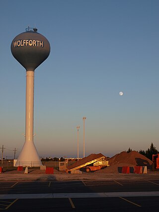
Wolfforth is a town located in Lubbock County, Texas, United States. It is a southwestern suburb of Lubbock. The population was 5,521 at the 2020 census.

<span class="mw-page-title-main">Bovina, Texas</span> City in Texas, United States

Bovina is a city in Parmer County, Texas, United States. The population was 1,868 at the 2010 census.

<span class="mw-page-title-main">O'Donnell, Texas</span> City in Texas, United States

O'Donnell is a West Texas city that lies primarily in Lynn County, with a small portion extending south into Dawson County, Texas, United States. Its population was 831 at the 2010 census, down from 1,011 at the 2000 census. The Lynn county portion of O'Donnell is part of the Lubbock Metropolitan area.

<span class="mw-page-title-main">Abernathy, Texas</span> City in Texas, United States

Abernathy is a city in Hale and Lubbock counties in the U.S. state of Texas. The population was 2,805 at the 2010 census.

References

  1. 1 2 "Smyer". Geographic Names Information System . United States Geological Survey, United States Department of the Interior.
  2. "2019 U.S. Gazetteer Files". United States Census Bureau. Retrieved August 7, 2020.
  3. 1 2 "Population and Housing Unit Estimates". United States Census Bureau. May 24, 2020. Retrieved May 27, 2020.
  4. 1 2 "Geographic Identifiers: 2010 Census Summary File 1 (G001): Smyer town, Texas". American Factfinder. U.S. Census Bureau. Archived from the original on February 13, 2020. Retrieved March 13, 2018.
  5. "US Gazetteer files: 2010, 2000, and 1990". United States Census Bureau. February 12, 2011. Retrieved April 23, 2011.
  6. "Census of Population and Housing". Census.gov. Retrieved June 4, 2015.
  7. "U.S. Census website". United States Census Bureau . Retrieved January 31, 2008.