Related Research Articles
Location-based service (LBS) is a general term denoting software services which use geographic data and information to provide services or information to users. LBS can be used in a variety of contexts, such as health, indoor object search, entertainment, work, personal life, etc. Commonly used examples of location-based services include navigation software, social networking services, location-based advertising, and tracking systems. LBS can also include mobile commerce when taking the form of coupons or advertising directed at customers based on their current location. LBS also includes personalized weather services and even location-based games.
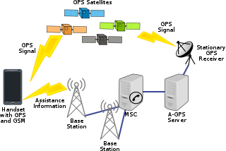
Assisted GNSS (A-GNSS) is a GNSS augmentation system that often significantly improves the startup performance—i.e., time-to-first-fix (TTFF)—of a global navigation satellite system (GNSS). A-GNSS works by providing the necessary data to the device via a radio network instead of the slow satellite link, essentially "warming up" the receiver for a fix. When applied to GPS, it is known as assisted GPS or augmented GPS. Other local names include A-GANSS for Galileo and A-Beidou for BeiDou.

Mobile phone tracking is a process for identifying the location of a mobile phone, whether stationary or moving. Localization may be affected by a number of technologies, such as the multilateration of radio signals between (several) cell towers of the network and the phone or by simply using GNSS. To locate a mobile phone using multilateration of mobile radio signals, the phone must emit at least the idle signal to contact nearby antenna towers and does not require an active call. The Global System for Mobile Communications (GSM) is based on the phone's signal strength to nearby antenna masts.

Spatial analysis is any of the formal techniques which studies entities using their topological, geometric, or geographic properties. Spatial analysis includes a variety of techniques using different analytic approaches, especially spatial statistics. It may be applied in fields as diverse as astronomy, with its studies of the placement of galaxies in the cosmos, or to chip fabrication engineering, with its use of "place and route" algorithms to build complex wiring structures. In a more restricted sense, spatial analysis is geospatial analysis, the technique applied to structures at the human scale, most notably in the analysis of geographic data. It may also be applied to genomics, as in transcriptomics data.
In marketing, geomarketing is a discipline that uses geolocation in the process of planning and implementation of marketing activities. It can be used in any aspect of the marketing mix — the product, price, promotion, or place. Market segments can also correlate with location, and this can be useful in targeted marketing.
A GPS tracking unit, geotracking unit, satellite tracking unit, or simply tracker is a navigation device normally on a vehicle, asset, person or animal that uses satellite navigation to determine its movement and determine its WGS84 UTM geographic position (geotracking) to determine its location. Satellite tracking devices may send special satellite signals that are processed by a receiver.
Mobile marketing is a multi-channel online marketing technique focused at reaching a specific audience on their smartphones, feature phones, tablets, or any other related devices through websites, e-mail, SMS and MMS, social media, or mobile applications. Mobile marketing can provide customers with time and location sensitive, personalized information that promotes goods, services, appointment reminders and ideas. In a more theoretical manner, academic Andreas Kaplan defines mobile marketing as "any marketing activity conducted through a ubiquitous network to which consumers are constantly connected using a personal mobile device".
Traffic reporting is the near real-time distribution of information about road conditions such as traffic congestion, detours, and traffic collisions. The reports help drivers anticipate and avoid traffic problems. Traffic reports, especially in cities, may also report on major delays to mass transit that does not necessarily involve roads. In addition to periodic broadcast reports, traffic information can be transmitted to GPS units, smartphones, and personal computers.

Mobile social networking is social networking where individuals with similar interests converse and connect with one another through their mobile phone and/or tablet. Much like web-based social networking, mobile social networking occurs in virtual communities.
Mobile local search is a technology that lets people search for local things using mobile equipment such as mobile phones, PDAs, and other mobile devices. Mobile local search satisfies the need to offer a mobile subscriber spontaneous access to near-position services and information such as businesses, products, events, restaurant, movie theatre or other local information. Mobile local search is the search and discovery of persons, places, and things within an identifiable space defined by distinct parameters. These parameters are evolving. Today they include social networks, individuals, cities, neighborhoods, landmarks, and actions that are relevant to the searcher's past, current, and future location. These parameters provide structure to vertically deep and horizontally broad data categories that can stand-alone or are combined to comprise searchable directories.

Geosocial networking is a type of social networking in which geographic services and capabilities such as geocoding and geotagging are used to enable additional social dynamics. User-submitted location data or geolocation techniques can allow social networks to connect and coordinate users with local people or events that match their interests. Geolocation on web-based social network services can be IP-based or use hotspot trilateration. For mobile social networks, texted location information or mobile phone tracking can enable location-based services to enrich social networking.
Mobile blogging is a method of publishing to a website or blog from a mobile phone or other handheld device. A moblog helps habitual bloggers to post write-ups directly from their phones even when on the move. Mobile blogging has been made possible by technological convergence, as bloggers have been able to write, record and upload different media all from a single, mobile device. At the height of its growth in 2006, mobile blogging experienced 70,000 blog creations a day and 29,100 blog posts an hour. Between 2006 and 2010, blogging among teens declined from 28% to 14%, while blogging among adults over 30 increased from 7% to 11%. However, the growing number of multi-platform blogging apps has increased mobile blogging popularity in recent years creating a brand new market that many celebrities, regular bloggers and specialists are utilizing to widen their social reach.
Real-time geotagging refers to the automatic technique of acquiring media, associating a specific location with the media, transferring the media to an online map and publishing the media in real time. It is thus an extension of an automatic geotagging process, requiring an in-built or attached location acquisition device, but also requires communication with a wireless data transfer device. Most modern smartphones and several digital cameras already integrate camera, aGPS, and wireless data transfer into one device, thus directly producing a geotagged photograph. Real-time geotagging is sometimes referred to as "mobile geotagging" or "autogeotagging", but this does not imply the real-time publishing step.
Radio resource location services (LCS) protocol (RRLP) applies to GSM and UMTS Cellular Networks. It is used to exchange messages between a handset and an SMLC in order to provide geolocation information; e.g., in the case of emergency calls. The protocol was developed in order to fulfil the Wireless Enhanced 911 requirements in the United States. However, since the protocol does not require any authentication, and can be used outside of a voice call or SMS transfer, its use is not restricted to emergency calls and can be used by law enforcement to pinpoint the exact geolocation of the target's mobile phone. RRLP was first specified in 3GPP TS 04.31 - Location Services (LCS); Mobile Station (MS) - Serving Mobile Location Centre (SMLC); Radio Resource LCS Protocol (RRLP).

Mobile device forensics is a branch of digital forensics relating to recovery of digital evidence or data from a mobile device under forensically sound conditions. The phrase mobile device usually refers to mobile phones; however, it can also relate to any digital device that has both internal memory and communication ability, including PDA devices, GPS devices and tablet computers.
Ambient awareness (AmA) is a term used by social scientists to describe a form of peripheral social awareness through social media. This awareness is propagated from relatively constant contact with one's friends and colleagues via social networking platforms on the Internet. The term essentially defines the sort of omnipresent knowledge one experiences by being a regular user of these media outlets that allow a constant connection with one's social circle.
Mobile marketing research is a method of data collection using the functions of mobile phones, smartphones, and PDAs. PDAs were the main medium used in the late 1990s and early 2000s before smartphones replaced them. They typically included features such as calendars, contact lists, note-taking applications, and basic computing capabilities. Notable examples of PDAs include the Palm Pilot, BlackBerry, and early versions of the Pocket PC. It utilized mobile communication for research purposes.
Data philanthropy describes a form of collaboration in which private sector companies share data for public benefit. There are multiple uses of data philanthropy being explored from humanitarian, corporate, human rights, and academic use. Since introducing the term in 2011, the United Nations Global Pulse has advocated for a global "data philanthropy movement".
Spatial cloaking is a privacy mechanism that is used to satisfy specific privacy requirements by blurring users’ exact locations into cloaked regions. This technique is usually integrated into applications in various environments to minimize the disclosure of private information when users request location-based service. Since the database server does not receive the accurate location information, a set including the satisfying solution would be sent back to the user. General privacy requirements include K-anonymity, maximum area, and minimum area.

Mobile positioning data (MPD) is a form of big datawhich results from the high data volumes of mobile positioning – tracking the location of mobile phones.
References
- ↑ Ahas, R. & Mark, Ü. (2005). Location based services - new challenges for planning and public administration? [ dead link ] Futures 37, 547-561