Soil morphology

Last updated
Field equipment for soil description Soil-Munsell-Colour-Book.jpg
Field equipment for soil description

Soil morphology is the branch of soil science dedicated to the technical description of soil, [1] particularly physical properties including texture, color, structure, and consistence. Morphological evaluations of soil are typically performed in the field on a soil profile containing multiple horizons. [2]

Contents

Along with soil formation and soil classification, soil morphology is considered part of pedology, one of the central disciplines of soil science. [3]

Background

Since the origin of agriculture, humans have understood that soils contain different properties which affect their ability to grow crops. [4] However, soil science did not become its own scientific discipline until the 19th century, and even then early soil scientists were broadly grouped as either "agro-chemists" or "agro-geologists" due to the enduring strong ties of soil to agriculture. These agro-geologists examined soils in natural settings and were the first to scientifically study soil morphology. [5]

A team of Russian early soil scientists led by V.V. Dokuchaev observed soil profiles with similar horizons in areas with similar climate and vegetation, despite being hundreds of kilometers apart. [6] Dokuchaev's work, along with later contributions from K.D. Glinka, C.F. Marbut, and Hans Jenny, established soils as independent, natural bodies with unique properties caused by their equally unique combinations of climate, biological activity, relief, parent material, and time. Soil properties had previously been inferred from geological or environmental conditions alone, but with this new understanding, soil morphological properties were now used to evaluate the integrated influence of these factors. [7]

Soil morphology became the basis for understanding observations, experiments, behavior, and practical uses of different soils. [7] To standardize morphological descriptions, official guidelines and handbooks for describing soil were first published in the 1930s by Charles Kellogg and the United States Department of Agriculture-Soil Conservation Service for the United States and by G.R. Clarke for the United Kingdom. Many other countries and national soil survey organizations have since developed their own guidelines. [5]

Properties and Procedure

Standard field description sheet used by soil scientists in the United States NRCS pedon description soil field sheet.pdf
Standard field description sheet used by soil scientists in the United States

Observations of soil morphology are typically performed in the field on soil profiles exposed by excavating a pit or extracting a core with a push tube (handheld or hydraulic) or auger. [8] A soil profile is one face of a pedon, or an imaginary three-dimensional unit of soil that would display the full range of properties characteristic of a particular soil. Pedons generally occupy between 1 and 10 m2 of surface land area and are the fundamental unit of field-based soil study. [9]

Many soil scientists in the United States document soil morphological descriptions using the standard Pedon Description field sheet published by the USDA-NRCS. In addition to location, landscape, vegetation, topographic, and other site information, soil morphology descriptions generally include the following properties:

Horizonation

Soil profiles contain multiple layers, known as horizons, that are generally parallel to the soil surface. These horizons are distinguishable from adjacent layers by their changes in morphological properties as the soil naturally forms. The same soil horizons may be named and labeled differently in various soil classification systems around the world, though most systems contain the following:

Diagram of soil horizons Horizons.gif
Diagram of soil horizons

In addition to the horizon name, the distinctness and topography of each horizon's lower boundary are described. Boundary distinctness is determined by how accurately the border between horizons can be identified and may be very abrupt, abrupt, clear, gradual, or diffuse. Boundary topography refers to the horizontal variation of the border, which is often not parallel to the soil surface and may even be discontinuous. Topography categories include smooth, wavy, irregular, and broken. [2]

Color

10YR hue in the Munsell soil color book Munsell-soil1 hg.jpg
10YR hue in the Munsell soil color book

Soil color is quantitatively described using the Munsell color system, which was developed in the early 20th century by Albert Munsell. Munsell was a painter and the system covers the entire range of colors, though the specially adapted Munsell soil color books commonly used in field description only include the most relevant colors for soil. [10]

The Munsell color system includes the following three components:

Colors in soil can be quite diverse and result from organic matter content, mineralogy, and the presence and oxidation states of iron and manganese oxides. Organic-rich soils tend to be dark brown or even black due to organic matter accumulating on the mineral particles. Well-drained and highly weathered soils may be bright red or brown from oxidized iron, while reduced iron can impart gray or blue colors and indicate poor drainage. When soil is saturated for prolonged periods, oxygen availability is limited and iron may become a biological electron acceptor. Reduced iron is more soluble than oxidized iron and is easily leached from particle coatings, which exposes bare, light-colored silicate minerals and results in iron depletions. When iron reduction and/or depletion makes gray the dominant matrix color, the soil is said to be gleyed. [9]

Soil color is also moisture dependent, specifically the color value. It is important to note the moisture status as "moist" when adding water does not change the soil color, or as "dry" when the soil is air dry. [11] The standard moisture status for describing soil in the field varies regionally; humid areas generally use the moist state while arid ones use the dry state. In detailed descriptions, both the moist and dry colors should be recorded. [7]

Soil texture

Soil texture is the analysis and classification of the particle size distribution in soil. The relative amounts of sand, silt, and clay particles determine a soil's texture, which affects the appearance, feel and chemical properties of the soil. [12]

Soil texture-by-feel method NRCSAZ02090(14214)(NRCS Photo Gallery).jpg
Soil texture-by-feel method

Field methods

To estimate by hand in the field, soil scientists take a handful of sifted soil and moisten it with water until it holds together. The soil is then rolled into a ball nearing 1-2 inches in diameter and squeezed between the thumb and side of the index finger. Ribbons should be made as long as possible until it naturally breaks under its own weight. Longer ribbons indicate a higher clay percentage. The relative smoothness or grittiness indicates the sand percentage, and with practice, this technique can provide accurate textural class determinations. [9]

Lab methods

Soil texture triangle SoilTriangle.jpg
Soil texture triangle

An experienced soil scientist can determine soil texture in the field with decent accuracy, as described above. However, not all soils lend themselves to accurate field determinations of soil texture due to the presence of other particles that interfere with measuring the concentration of sand, silt and clay. The mineral texture can be obfuscated by high soil organic matter, iron oxides, amorphous or short-range-order aluminosilicates, and carbonates.

In order to precisely determine the amount of clay, sand and silt in a soil, it must be taken to a laboratory for analysis. A strategy known as particle size analysis (PSA) is performed, beginning with the pretreatment of the soil in order to remove all other particles such as organic matter that may interfere with the classification. Pretreatment must leave the soil as strictly sand, silt and clay particles. Pretreatment may consist of processes such as the sieving of the soil to remove larger particles, thus allowing the soil to be dispersed properly. Hydrometer tests may then be used to calculate the amounts of sand, silt and clay present. This consists of mixing the pretreated soil with water and then allowing the mixture to settle, making note of the hydrometer reading. Sand particles are the largest, and thus will settle the quickest, followed by the silt particles, and lastly the clay particles. The sections are then dried and weighed. The three sections should add up to 100% in order for the test to be considered successful. Laser diffraction analysis can also be used as alternative to the sieving and hydrometer methods. [13]

From here, the soil can be classified using a soil texture triangle, which labels the type of soil based on the percentages of each particle in the sample.

Structure

Strong medium angular blocky soil structure from Oklahoma, USA Angular blocky soil structure.jpg
Strong medium angular blocky soil structure from Oklahoma, USA

Soil particles naturally aggregate together into larger units or shapes referred to as "peds". Peds have planes of weakness between them are generally identified by probing exposed soil profiles with a knife to pry out and gently break apart volumes of soil. [11]

Morphological descriptions of soil structure contain assessments of shape, size, and grade. Structure shapes include granular, platy, blocky, prismatic, columnar, and others, including the "structureless" shapes of massive and single-grained. Size is classified as one of six categories ranging from "very fine" to "extremely coarse", with different size limits for the various shapes and measurements taken on the smallest ped dimension. Grade indicates the distinctness of peds, or how easily distinguishable they are from each other, and is described with the classes "weak", "moderate", and "strong". [7]

Structure is often best evaluated while the soil is relatively dry, as peds may swell with moisture, press together and reduce the definition between each ped. [9]

Porosity

Porosity of topsoil is a measure of the pore space in soil which typically decreases as grain size increases. This is due to soil aggregate formation in finer textured surface soils when subject to soil biological processes. Aggregation involves particulate adhesion and higher resistance to compaction. Porosity of a soil is a function of the soil's bulk density, which is based on the composition of the soil. Sandy soils typically have higher bulk densities and lower porosity than silty or clayey soils. This is because finer grained particles have a larger amount of pore space than coarser grained particles. The table below displays the deal bulk densities that both allow and restrict root growth for the three main texture classifications. The porosity of a soil is an important factor that determines the amount of water a soil can hold, how much air it can hold, and subsequently how well plant roots can grow within the soil. [14]

Soil porosity is complex. Traditional models regard porosity as continuous. This fails to account for anomalous features and produces only approximate results. Furthermore, it cannot help model the influence of environmental factors which affect pore geometry. A number of more complex models have been proposed, including fractals, bubble theory, cracking theory, Boolean grain process, packed sphere, and numerous other models. [15]

Micromorphology

Soil micromorphology refers to the description, measurement, and interpretation of soil features that are too small to be observed by the unassisted eye. [11] While micromorphological descriptions may begin in the field with the use of a 10x hand lens, much more can be described using thin sections made of the soil with the aid of a petrographic polarizing light microscope. The soil can be impregnated with an epoxy resin, but more commonly with a polyester resin (crystic 17449) and sliced and ground to 0.03 millimeter thickness and examined by passing light through the thin soil plasma.[ citation needed ]

Micromorphology in archaeology

Soil micromorphology has been a recognized technique in soil science for some 50 years and experience from pedogenic and paleosol studies first permitted its use in the investigation of archaeologically buried soils. More recently, the science has expanded to encompass the characterization of all archeological soils and sediments and has been successful in providing unique cultural and paleoenvironmental information from a whole range of archaeological sites. [16]

Soil formation

Form

Soils are formed from their respective parent material, which may or may not match the composition of the bedrock that they lie on top of. Through biological and chemical processes as well as natural processes such as wind and water erosion, parent material can be broken down. The chemical and physical properties of this parent material is reflected in the qualities of the resulting soil. Climate, topography, and biological organisms all have an impact on the formation of soils in various geographic locations. [17]

Topography

A steep landform is going to see an increased amount of runoff when compared to a flat landform. Increased runoff can inhibit soil formation as the upper layers continue to get stripped off because they are not developed enough to support root growth. Root growth can help prevent erosion as the roots act to keep the soil in place. This phenomenon leads to soils on slopes being thinner and less developed than soils found on plains or plateaus. [18]

Climate

Varying levels of precipitation and wind have impacts on the formation of soils. Increased precipitation can lead to increased levels of runoff as previously described, but regular amounts of precipitation can encourage plant root growth which works to stop runoff. The growth of vegetation in a certain area can also work to increase the depth and nutrient quality of a topsoil, as decomposition of organic matter works to strengthen organic soil horizons.

Biological processes

Varying levels of microbial activity can have a range of impacts on soil formation. Most often, biological processes work to disrupt existing soil formation which leads to chemical translocation. the movement of these chemicals can make nutrients available, which can increase plant root growth.

See also

Related Research Articles

<span class="mw-page-title-main">Soil</span> Mixture of organic matter, minerals, gases, liquids, and organisms that together support life

Soil, also commonly referred to as earth or dirt, is a mixture of organic matter, minerals, gases, liquids, and organisms that together support the life of plants and soil organisms. Some scientific definitions distinguish dirt from soil by restricting the former term specifically to displaced soil.

<span class="mw-page-title-main">Shale</span> Fine-grained, clastic sedimentary rock

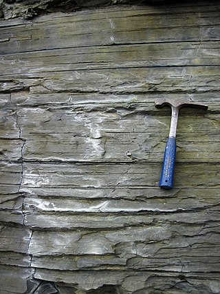
Shale is a fine-grained, clastic sedimentary rock formed from mud that is a mix of flakes of clay minerals (hydrous aluminium phyllosilicates, e.g. kaolin, Al2Si2O5(OH)4) and tiny fragments (silt-sized particles) of other minerals, especially quartz and calcite. Shale is characterized by its tendency to split into thin layers (laminae) less than one centimeter in thickness. This property is called fissility. Shale is the most common sedimentary rock.

<span class="mw-page-title-main">Sedimentary rock</span> Rock formed by the deposition and cementation of particles

Sedimentary rocks are types of rock that are formed by the accumulation or deposition of mineral or organic particles at Earth's surface, followed by cementation. Sedimentation is the collective name for processes that cause these particles to settle in place. The particles that form a sedimentary rock are called sediment, and may be composed of geological detritus (minerals) or biological detritus. The geological detritus originated from weathering and erosion of existing rocks, or from the solidification of molten lava blobs erupted by volcanoes. The geological detritus is transported to the place of deposition by water, wind, ice or mass movement, which are called agents of denudation. Biological detritus was formed by bodies and parts of dead aquatic organisms, as well as their fecal mass, suspended in water and slowly piling up on the floor of water bodies. Sedimentation may also occur as dissolved minerals precipitate from water solution.

In geotechnical engineering, soil structure describes the arrangement of the solid parts of the soil and of the pore space located between them. It is determined by how individual soil granules clump, bind together, and aggregate, resulting in the arrangement of soil pores between them. Soil has a major influence on water and air movement, biological activity, root growth and seedling emergence. There are several different types of soil structure. It is inherently a dynamic and complex system that is affected by different factors.

USDA soil taxonomy (ST) developed by the United States Department of Agriculture and the National Cooperative Soil Survey provides an elaborate classification of soil types according to several parameters and in several levels: Order, Suborder, Great Group, Subgroup, Family, and Series. The classification was originally developed by Guy Donald Smith, former director of the U.S. Department of Agriculture's soil survey investigations.

<span class="mw-page-title-main">Loam</span> Soil composed of similar proportions of sand and silt, and somewhat less clay

Loam is soil composed mostly of sand, silt, and a smaller amount of clay. By weight, its mineral composition is about 40–40–20% concentration of sand–silt–clay, respectively. These proportions can vary to a degree, however, and result in different types of loam soils: sandy loam, silty loam, clay loam, sandy clay loam, silty clay loam, and loam.

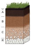
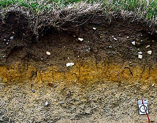
A soil horizon is a layer parallel to the soil surface whose physical, chemical and biological characteristics differ from the layers above and beneath. Horizons are defined in many cases by obvious physical features, mainly colour and texture. These may be described both in absolute terms and in terms relative to the surrounding material, i.e. 'coarser' or 'sandier' than the horizons above and below.

<span class="mw-page-title-main">World Reference Base for Soil Resources</span> International soil classification system

The World Reference Base for Soil Resources (WRB) is an international soil classification system for naming soils and creating legends for soil maps. The currently valid version is the fourth edition 2022. It is edited by a working group of the International Union of Soil Sciences (IUSS).

Claypan is a dense, compact, slowly permeable layer in the subsoil. It has a much higher clay content than the overlying material, from which it is separated by a sharply defined boundary. The dense structure restricts root growth and water infiltration. Therefore, a perched water table might form on top of the claypan. In the Canadian classification system, claypan is defined as a clay-enriched illuvial B (Bt) horizon.

<span class="mw-page-title-main">Mudrock</span> Type of sedimentary rock

Mudrocks are a class of fine-grained siliciclastic sedimentary rocks. The varying types of mudrocks include siltstone, claystone, mudstone, slate, and shale. Most of the particles of which the stone is composed are less than 116 mm and are too small to study readily in the field. At first sight, the rock types appear quite similar; however, there are important differences in composition and nomenclature.

Soil texture is a classification instrument used both in the field and laboratory to determine soil classes based on their physical texture. Soil texture can be determined using qualitative methods such as texture by feel, and quantitative methods such as the hydrometer method based on Stokes' law. Soil texture has agricultural applications such as determining crop suitability and to predict the response of the soil to environmental and management conditions such as drought or calcium (lime) requirements. Soil texture focuses on the particles that are less than two millimeters in diameter which include sand, silt, and clay. The USDA soil taxonomy and WRB soil classification systems use 12 textural classes whereas the UK-ADAS system uses 11. These classifications are based on the percentages of sand, silt, and clay in the soil.

<span class="mw-page-title-main">Clastic rock</span> Sedimentary rocks made of mineral or rock fragments

Clastic rocks are composed of fragments, or clasts, of pre-existing minerals and rock. A clast is a fragment of geological detritus, chunks, and smaller grains of rock broken off other rocks by physical weathering. Geologists use the term clastic to refer to sedimentary rocks and particles in sediment transport, whether in suspension or as bed load, and in sediment deposits.

Hydrophobic soil is a soil whose particles repel water. The layer of hydrophobicity is commonly found at or a few centimeters below the surface, parallel to the soil profile. This layer can vary in thickness and abundance and is typically covered by a layer of ash or burned soil.

Soil chemistry is the study of the chemical characteristics of soil. Soil chemistry is affected by mineral composition, organic matter and environmental factors. In the early 1870s a consulting chemist to the Royal Agricultural Society in England, named J. Thomas Way, performed many experiments on how soils exchange ions, and is considered the father of soil chemistry. Other scientists who contributed to this branch of ecology include Edmund Ruffin, and Linus Pauling.

<span class="mw-page-title-main">Soil color</span> Morphological property of soil

Soil color is often the most visually apparent property of soil. While color itself does not influence the behavior or practical use of soils, it does indicate important information about the soil organic matter content, mineralogy, moisture, and drainage.

The pore space of soil contains the liquid and gas phases of soil, i.e., everything but the solid phase that contains mainly minerals of varying sizes as well as organic compounds.

<span class="mw-page-title-main">Ped</span> Aggregates of soil particles formed naturally

In soil science, peds are aggregates of soil particles formed as a result of pedogenic processes; this natural organization of particles forms discrete units separated by pores or voids. The term is generally used for macroscopic structural units when observing soils in the field. Soil peds should be described when the soil is dry or slightly moist, as they can be difficult to distinguish when wet.

Kamrun Nahar is a Bangladeshi soil scientist and environmentalist. A prominent biofuels researcher of Bangladesh, her research and publications also aimed to lower dependence on petroleum based foreign oil by producing low carbon and sulphur emitting biofuels from the second generation energy crops cultivated in the unused wastelands of Bangladesh for use in home generators to supplement power.

The physical properties of soil, in order of decreasing importance for ecosystem services such as crop production, are texture, structure, bulk density, porosity, consistency, temperature, colour and resistivity. Soil texture is determined by the relative proportion of the three kinds of soil mineral particles, called soil separates: sand, silt, and clay. At the next larger scale, soil structures called peds or more commonly soil aggregates are created from the soil separates when iron oxides, carbonates, clay, silica and humus, coat particles and cause them to adhere into larger, relatively stable secondary structures. Soil bulk density, when determined at standardized moisture conditions, is an estimate of soil compaction. Soil porosity consists of the void part of the soil volume and is occupied by gases or water. Soil consistency is the ability of soil materials to stick together. Soil temperature and colour are self-defining. Resistivity refers to the resistance to conduction of electric currents and affects the rate of corrosion of metal and concrete structures which are buried in soil. These properties vary through the depth of a soil profile, i.e. through soil horizons. Most of these properties determine the aeration of the soil and the ability of water to infiltrate and to be held within the soil.

References

  1. Owens, P. R.; Rutledge, E. M. (2005-01-01), "MORPHOLOGY", in Hillel, Daniel (ed.), Encyclopedia of Soils in the Environment, Oxford: Elsevier, pp. 511–520, doi:10.1016/b0-12-348530-4/00002-3, ISBN   978-0-12-348530-4 , retrieved 2023-02-26
  2. 1 2 Buol, Stanley W.; Southard, Randall J.; Graham, Robert A.; McDaniel, Paul A. (2003). Soil genesis and classification (5th ed.). Ames, Iowa: Iowa State Press. ISBN   0-8138-2873-2. OCLC   50034831.
  3. Arnold, Richard W. (2016-01-01), Sparks, Donald L. (ed.), Perspectives About the National Cooperative Soil Survey, Advances in Agronomy, vol. 136, Academic Press, pp. 1–26, doi:10.1016/bs.agron.2015.11.003, ISBN   9780128046814 , retrieved 2023-02-26
  4. Brevik, Eric C.; Hartemink, Alfred E. (2010-10-15). "Early soil knowledge and the birth and development of soil science". CATENA. 83 (1): 23–33. Bibcode:2010Caten..83...23B. doi:10.1016/j.catena.2010.06.011. ISSN   0341-8162.
  5. 1 2 Hartemink, Alfred E. (2009-11-15). "The depiction of soil profiles since the late 1700s". CATENA. 79 (2): 113–127. Bibcode:2009Caten..79..113H. doi:10.1016/j.catena.2009.06.002. ISSN   0341-8162.
  6. Brady, Nyle C. (2014). Elements of the nature and properties of soils. Ray R. Weil (4th ed.). Harlow, Essex. p. 54. ISBN   978-1-292-03929-9. OCLC   880670180.{{cite book}}: CS1 maint: location missing publisher (link)
  7. 1 2 3 4 5 Soil Science Division Staff. 2017. Soil and Soil Survey. In C. Ditzler, K. Scheffe, and H.C. Monger (eds.). Soil survey manual, USDA Handbook 18. Government Printing Office, Washington, D.C.
  8. Schonenberger, P.J., D.A. Wysocki, E.C. Benham, and Soil Survey Staff. 2012. Field book for describing and sampling soils, Version 3.0. Natural Resources Conservation Service, National Soil Survey Center, Lincoln, NE, USA. https://www.nrcs.usda.gov/sites/default/files/2022-09/field-book.pdf
  9. 1 2 3 4 Brady, Nyle C.; Weil, Ray R. (2010). Elements of the nature and properties of soils (3rd ed.). Upper Saddle River, N.J.: Prentice Hall. ISBN   978-0-13-501433-2. OCLC   276340542.
  10. Owens, P. R.; Rutledge, E. M. (2005). Encyclopedia of soils in the environment. Daniel Hillel, Jerry L. Hatfield (1st ed.). Oxford, UK: Elsevier/Academic Press. p. 514. ISBN   0-12-348530-4. OCLC   52486575.
  11. 1 2 3 Buol, S. W. (2011). Soil genesis and classification. R. J. Southard, R. C. Graham, P. A. McDaniel (6th ed.). Chichester, West Sussex. ISBN   978-0-470-96062-2. OCLC   747546196.{{cite book}}: CS1 maint: location missing publisher (link)
  12. Brown, Katharine. “Soil Texture – Measuring in the Field.” Measuring Soil Texture in the Field | Fact Sheets, 2020, soilquality.org.au/factsheets/soil-texture.
  13. Ryżak, Magdalena; Bieganowski, Andrzej (August 2011). "Methodological aspects of determining soil particle‐size distribution using the laser diffraction method". Journal of Plant Nutrition and Soil Science. 174 (4): 624–633. doi:10.1002/jpln.201000255. ISSN   1436-8730.
  14. USDA Natural Resource Conservation Service. Soil Quality Indicators: Bulk Density [Fact sheet]. U.S Department of Agriculture. https://www.nrcs.usda.gov/Internet/FSE_DOCUMENTS/nrcs142p2_053256.pdf
  15. Horgan, Graham W. (1996). "A review of soil pore models" (PDF). Archived from the original (PDF) on 2005-05-15. Retrieved 2006-11-03.
  16. Macphail, Richard I; Courty, Marie-Agnès; Goldberg, Paul (January 1990). "Soil micromorphology in archaeology". Endeavour. 14 (4): 163–171. doi:10.1016/0160-9327(90)90039-t. ISSN   0160-9327.
  17. Queensland, c=AU; o=The State of. "How soils form | Soils explained". www.qld.gov.au. Retrieved 2020-11-25.{{cite web}}: CS1 maint: multiple names: authors list (link)
  18. "Soil Formation - an overview | ScienceDirect Topics". www.sciencedirect.com. Retrieved 2020-11-25.