The Territory of Ashmore and Cartier Islands is an uninhabited Australian external territory consisting of four low-lying tropical islands in two separate reefs, as well as the 12-nautical-mile territorial sea generated by the islands. The territory is located in the Indian Ocean situated on the edge of the continental shelf, about 320 km (199 mi) off the northwest coast of Australia and 144 km (89 mi) south of the Indonesian island of Rote.

The Territory of Christmas Island is an Australian external territory in the Indian Ocean comprising the island of the same name. It is located approximately 350 kilometres south of Java and Sumatra and about 1,550 km (840 nmi) north-west of the closest point on the Australian mainland. It has an area of 135 square kilometres (52 sq mi).

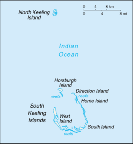
The Cocos (Keeling) Islands, officially the Territory of Cocos (Keeling) Islands, are an Australian external territory in the Indian Ocean, comprising a small archipelago approximately midway between Australia and Sri Lanka and relatively close to the Indonesian island of Sumatra. The territory's dual name reflects that the islands have historically been known as either the Cocos Islands or the Keeling Islands.

The Coral Sea Islands Territory is an external territory of Australia which comprises a group of small and mostly uninhabited tropical islands and reefs in the Coral Sea, north-east of Queensland, Australia. The only inhabited island is Willis Island. The territory covers 780,000 km2 (301,160 sq mi), most of which is ocean, extending east and south from the outer edge of the Great Barrier Reef and includes Heralds Beacon Island, Osprey Reef, the Willis Group and fifteen other reef/island groups. Cato Island is the highest point in the Territory.

Solomon Islands is an island country in the South Pacific Ocean, that lies east of Papua New Guinea.
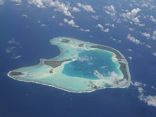
An atoll is a ring-shaped island, including a coral rim that encircles a lagoon. There may be coral islands or cays on the rim. Atolls are located in warm tropical or subtropical parts of the oceans and seas where corals can develop. Most of the approximately 440 atolls in the world are in the Pacific Ocean.
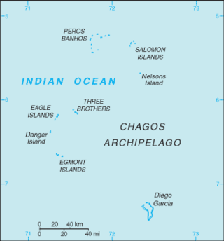
The British Indian Ocean Territory (BIOT) is an archipelago of 55 islands in the Indian Ocean, located south of India. It is situated approximately halfway between Africa and Indonesia. The islands form a semicircular group with an open sea towards the east. The largest, Diego Garcia, is located at the southern extreme end. It measures 60 square kilometres (23 sq mi) and accounts for almost three-quarters of the total land area of the territory. Diego Garcia is the only inhabited island and is home to the joint UK-US naval support facility. Other islands within the archipelago include Danger Island, Three Brothers Islands, Nelson Island, and Peros Banhos, as well as the island groups of the Egmont Islands, Eagle Islands, and the Salomon Islands.
This is a list of the extreme points of Asia, the points that are farther north, south, east or west than any other location on the continent.
This is a list of the extreme points of Eurasia, the points that are farther north, south, east or west than any other location on the continent. Some of these locations are open to debate, owing to the diverse definitions of Europe and Asia.
Cosmoledo Atoll is an atoll of the Aldabra Group and belongs to the Outer Islands of the Seychelles, and is located 1,029 km (639 mi) southwest of the capital, Victoria, on Mahé Island.
The Shire of Cocos (Keeling) Islands is a local government area which manages local affairs on the Australian external territory of Cocos (Keeling) Islands. The island is grouped with Western Australia but is administered by the Department of Infrastructure, Regional Development and Cities and an Administrator.

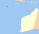
North Keeling is a small, uninhabited coral atoll, approximately 1.2 square kilometres (0.46 sq mi) in area, about 25 kilometres (16 mi) north of Horsburgh Island. It is the northernmost atoll and island of the Australian territory of the Cocos (Keeling) Islands. It consists of just one C-shaped island, a nearly closed atoll ring with a small opening into the lagoon, about 50 metres (160 ft) wide, on the east side. The lagoon is about 0.5 square kilometres (0.19 sq mi) in area. The island is home to the only surviving population of the endemic, and endangered, Cocos buff-banded rail, as well as large breeding colonies of seabirds. Since 1995, North Keeling Island and the surrounding sea to 1.5 kilometres (0.93 mi) from shore have been within the Pulu Keeling National Park.

Cocos Lagoon appears as a small incomplete coral atoll attached to the south-western coast of Guam near the area of the village of Malesso'. It stretches about 5.5 km (3.4 mi) east-west and 3.5 km (2.2 mi) north-south, covering an area of more than 10 km2 (3.9 sq mi).

Determining the boundaries between the continents is generally a matter of geographical convention. Several slightly different conventions are in use. The number of continents is most commonly considered seven but may range as low as four when Afro-Eurasia and the Americas are both considered as single continents. An island can be considered to be associated with a given continent by either lying on the continent's adjacent continental shelf or being a part of a microcontinent on the same principal tectonic plate. An island can also be entirely oceanic while still being associated with a continent by geology or by common geopolitical convention. Another example is the grouping into Oceania of the Pacific Islands with Australia and Zealandia.

The Cocos buff-banded rail, Gallirallus philippensis andrewsi, is an endangered subspecies of the buff-banded rail endemic to the Cocos (Keeling) Islands, an Australian Offshore Territory in the central-eastern Indian Ocean. The local Cocos Malay name of the bird is ayam hutan.

Although it is an Australian External Territory, the culture of the Cocos (Keeling) Islands has extensive influences from Malaysia and Indonesia.
The Home Island Foreshore is a heritage-listed cultural landscape at Jalan Panti, Home Island, Cocos (Keeling) Islands, Australia. It was added to the Australian Commonwealth Heritage List on 22 June 2004.
The South Keeling Islands are a group of islands of the Cocos (Keeling) Islands, next to North Keeling, about 27 km (17 mi) to the north. The Australian atoll is located in the Indian Ocean about 2,930 km (1,821 mi) northwest of Perth, 3,685 km (2,290 mi) west of Darwin, 960 km (597 mi) southwest of Christmas Island and more than 1,000 km (621 mi) southwest of Java and Sumatra.