
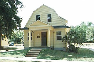
Lawrence Township is one of the twenty-two townships of Washington County, Ohio, United States. The 2020 census found 824 people in the township.
The Jaite Mill Historic District, also known as Jaite, is a nationally recognized historic district in Cuyahoga and Summit counties in the U.S. state of Ohio. The Cuyahoga County portion of the district is located in the city of Brecksville, while the Summit County portion is located in Sagamore Hills Township. Built in 1903 as the Jaite Company Paper Mill, its center is at the intersection of Vaughn and Riverview roads, north of the crossing of Interstates 80 and 271.

This is a list of the National Register of Historic Places listings in Preble County, Ohio.

The McColly Covered Bridge is a historic wooden covered bridge in western Logan County, Ohio, United States. Located in Washington Township near the community of Bloom Center, it is one of two remaining covered bridges in Logan County. It carries County Road 13 over the Great Miami River, approximately 5 miles (8.0 km) south of its source at Indian Lake.

St. Anthony's Catholic Church is a historic Roman Catholic church in Padua, an unincorporated community in Washington Township, Mercer County, Ohio, United States. Built in the late nineteenth century, it remains the home of a functioning congregation, and it has been recognized as a historically significant building because of its architecture.

St. Joseph's Catholic Church is a historic Roman Catholic church in Wapakoneta, Ohio, United States. Built in 1910, this church is home to an active Catholic parish, and it has been declared a historic site because of its well-preserved Romanesque Revival architecture.

The Harra Covered Bridge is a historic wooden covered bridge in Washington County, Ohio, United States. Located in western Watertown Township, about 2 miles (3.2 km) north of the community of Watertown, the bridge spans the South Branch of Wolf Creek near the intersection of State Route 339 and Township Road 172. Among the bridge's more distinctive features are its cut stone abutments, its metal roof, and the vertical siding. Although it has been open for well over one hundred years, it remains in strong structural condition, and it served daily traffic into the late twentieth century.
The Kinzer Mound is a Native American mound in Ross County, Ohio, United States. Located outside of the village of South Salem, the mound sits on high ground far from any stream. Built in a sub-conical shape; it is 7.6 feet (2.3 m) tall and has a diameter of approximately 70 feet (21 m).

The Lockington Covered Bridge was a historic covered bridge that once spanned the Great Miami River near Lockington, Ohio, United States. Built in 1848, it employed the Long Truss method of construction. Construction elements included vertical wooden siding, wooden structural elements, wooden shingles on its roof, and cut stone abutments. Measuring approximately 170 feet (52 m) long, the bridge was composed of two spans; it cost $1,500 to build.
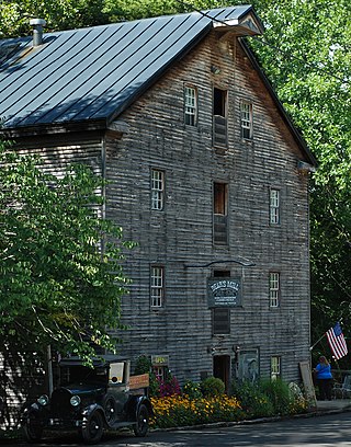
Bear's Mill is a historic gristmill near the city of Greenville in Darke County, Ohio, United States. Built in 1849, this watermill is the oldest existing industrial building in Darke County. Built by Manning Hart, a local contractor, the mill lies along Greenville Creek in southwestern Adams Township, midway between Greenville and the village of Gettysburg. It was purchased before its completion by Pennsylvanian Gabriel Bear, who completed and opened the mill in 1849. After his locally made millstones proved faulty, Bear travelled to France, where he acquired stones of a type regarded worldwide as of highest quality.
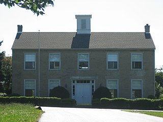
The South Salem Academy is a historic former school in South Salem, Ohio, United States. Built in 1842, it is a stone building constructed in the Federal style of architecture.
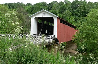
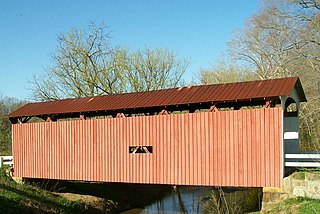
The Hune Covered Bridge is a historic wooden covered bridge in the southeastern part of the U.S. state of Ohio. Located northeast of the community of Dart, it spans the Little Muskingum River in northeastern Lawrence Township in the eastern part of Washington County. Local bridge builder Rollin Meredith erected it in 1879, using the Long-truss style of truss bridge design; the single-span bridge was named for the locally prominent Hune family. Among its design features are a metal roof, abutments of cut stone, and vertical siding. As a Long truss, the Hune Bridge is a valuable example of nineteenth-century architecture: few examples of this complicated style survive to the present day. In 1976, the Hune Bridge was listed on the National Register of Historic Places, both because of its place in local history and because of its historically significant construction.
The Hildreth Covered Bridge, also known as the "Hills Covered Bridge" or "Lafaber's Mill Bridge," is a historic covered bridge in Washington County, Ohio, United States. Located off State Route 26 in Newport Township, about 5 miles (8.0 km) east of the city of Marietta, the bridge historically carried Hills Bridge Road over the Little Muskingum River. Construction of the Hildreth Bridge was a long process: the most significant amount of work was done on the bridge in 1878, but the entire construction process occurred between 1871 and 1881. The identity of its builder is unknown.

The Old Enon Road Stone Arch Culvert is a historic limestone bridge in southern Clark County, Ohio, United States. It carries Rocky Point Road over Mud Run, a tributary of the Mad River, just west of its intersection with Old Mill Road. Located approximately 3.5 miles (5.6 km) east of Enon in eastern Mad River Township, it was constructed under the leadership of stonemason Samuel Taylor in 1871. In the past, the region was dotten with stone culverts, which were built in the nineteenth and early twentieth centuries to carry roads over small watercourses. Today, few stone culverts survive in Ohio; the Old Enon Road culvert is both Clark County's only such bridge in daily use and the oldest bridge of any type still open to daily traffic throughout the county.
The Root Covered Bridge is a historic wooden covered bridge in the southeastern part of the U.S. state of Ohio. Located off State Route 555 in far northern Decatur Township, Washington County, the bridge was built in 1878 in the Long truss mode of truss bridge construction. Measuring 65 feet (20 m) in its single span, it spans the West Branch of the Little Hocking River.
The Broadway Bridge is a historic arch bridge that spans Greenville Creek on the edge of downtown Greenville, a city in the far western part of the U.S. state of Ohio. Constructed in the early twentieth century, it carries one of the city's most important streets and connects the city's northern and southern sections. One of several large concrete bridges designed by a Cleveland engineer, it has been named a historic site.
The Rinard Covered Bridge, near Marietta, Ohio, was built in 1876. It was listed on the National Register of Historic Places in 1976.

The Roberts Covered Bridge is a Burr Truss covered bridge in Preble County, Ohio near Eaton. It was built in 1829, and was listed on the National Register of Historic Places in 1971.


