
Southampton County is a county located on the southern border of the Commonwealth of Virginia. North Carolina is to the south. As of the 2020 census, the population was 17,996. Its county seat is Courtland.

Isle of Wight County is a county located in the Hampton Roads region of the U.S. state of Virginia. It was named after the Isle of Wight, England, south of the Solent, from where many of its early colonists had come. As of the 2020 census, the population was 38,606. Its county seat is Isle of Wight, an unincorporated community.
Greensville County is a county located in the Commonwealth of Virginia. As of the 2020 census, the population was 11,391. Its county seat is Emporia.

Franklin is the southwesternmost independent city in Hampton Roads, Commonwealth of Virginia. As of the 2020 census, the population was 8,180. The Bureau of Economic Analysis combines the city of Franklin with Southampton County for statistical purposes.

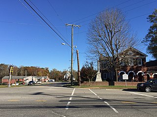
Courtland is an incorporated town in Southampton County, Virginia, United States. It is the county seat of Southampton County.
Saluda is a census-designated place (CDP) in and the county seat of Middlesex County, Virginia, United States. The population as of the 2010 Census was 769.

Sussex County is a rural county located in the Commonwealth of Virginia. As of the 2020 census, the population was 10,829. Its county seat is Sussex. It was formed in 1754 from Surry County. The county is named after the county of Sussex, England.
Emory is a census-designated place (CDP) in Washington County, Virginia, United States. The population was 1,237 at the 2020 census down from 1,251 at the 2010 census. The community is named for and is the location of Emory and Henry College.

Mathews is a census-designated place (CDP) in and the county seat of Mathews County, Virginia, United States. Established around 1700, the small town of Westville was designated as the county seat in 1791. Today, it is variously known as Mathews Court House, as well as simply "Mathews," its official postal name.
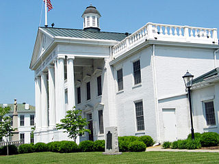
Sussex is a census-designated place (CDP) in and the county seat of Sussex County, Virginia, United States. The population as of the 2020 Census was 181.

Nottoway, or Nottoway Court House, is a census-designated place (CDP) in and the county seat of Nottoway County, Virginia, United States. The population as of the 2010 Census was 84.
Sedley is a census-designated place (CDP) in the middle of Southampton County, Virginia, United States. The population as of the 2010 Census was 470. It lies at an elevation of 89 feet.
Beards Fork is a census-designated place (CDP) and coal town in Fayette County, West Virginia, United States that was founded as a coal town. As of the 2010 census, its population was 199.

Bull Run Mountain Estates is a census-designated place in Prince William County, Virginia. The population as of the 2010 Census was 1,261. It is located along the east slope of the Bull Run Mountains, between Haymarket and Aldie.
Massanetta Springs is a census-designated place in Rockingham County, Virginia. The population as of the 2010 Census was 4,833.
Mount Sidney is a census-designated place in Augusta County, Virginia. The population as of the 2010 Census was 663.

Piney Mountain is a census-designated place in Albemarle County, Virginia. The population as of the 2010 Census was 1,130.
Rivanna is a census-designated place (CDP) in Albemarle County, Virginia, just east of Shadwell. The population as of the 2010 Census was 1,860. It consists mainly of the Glenmore gated community.

University of Virginia is a census-designated place in Albemarle County, Virginia. The population as of the 2010 Census was 7,704.

