Whiteash was a village in Williamson County, Illinois, United States. The population was 268 at the 2000 census, and dropped to 248 in the 2010 census. This village dissolved in 2014.

Bloomington Township is located in McLean County, Illinois. As of the 2010 census, its population was 2,851 and it contained 1,127 housing units. it is adjacent to the city of Bloomington.
Metro Lakeland is a name that was coined in the 1960s for an area of southern Illinois that is centered on the intersections of Interstate 57, Interstate 24, and Illinois Route 13 — a four-lane east-west highway connecting the communities of Murphysboro, Carbondale, Carterville, Herrin, Marion, and Harrisburg. Metro Lakeland was defined as Jackson, Williamson, Franklin, Saline, and Perry counties, with a combined population of approximately 210,000. Carbondale, Herrin, and Marion are the key urban areas, with a combined city-proper population of over 65,000 Carbondale, the site of Southern Illinois University, is the region's largest city. Metro Lakeland is about 88 miles (142 km) southeast of St. Louis, Missouri, or 120 miles (190 km) by Interstate highway.

Meacham Township is located in Marion County, Illinois. As of the 2010 census, its population was 375 and it contained 167 housing units.

Tonti Township is located in Marion County, Illinois. As of the 2010 census, its population was 1,013 and it contained 430 housing units.

Field Township is one of sixteen townships in Jefferson County, Illinois, USA. As of the 2010 census, its population was 1,468 and it contained 637 housing units.
Blairsville Precinct, formerly township, is Congressional Township 8 South, Range 1 East of the Third Principal Meridian located in Williamson County, Illinois. It is named for the village of Blairsville, Illinois.
Carterville Precinct, formerly township, is Congressional Township 9 South, Range 1 East of the Third Principal Meridian located in Williamson County, Illinois. It is named for the community of Carterville, Illinois.
West Marion Precinct, formerly township, is Congressional Township 9 South, Range 2 East of the Third Principal Meridian located in Williamson County, Illinois. It is named for the community of Marion, Illinois.
East Marion Precinct, formerly township, is Congressional Township 9 South, Range 3 East of the Third Principal Meridian located in Williamson County, Illinois. It is named for the community of Marion, Illinois.
Crab Orchard Precinct, formerly township, is Congressional Township 9 South, Range 4 East of the Third Principal Meridian located in Williamson County, Illinois. It is named for the community of Crab Orchard, Illinois.
Creal Springs Precinct, formerly township, is Congressional Township 10 South, Range 3 East of the Third Principal Meridian located in Williamson County, Illinois. It is named for the community of Creal Springs, Illinois.
Corinth Precinct, formerly township, is Congressional Township 8 South, Range 4 East of the Third Principal Meridian located in Williamson County, Illinois. It is named for the historical community of Corinth, Illinois. It was first known as Northern Precinct.
Stonefort Precinct, formerly township, is Congressional Township 10 South, Range 4 East of the Third Principal Meridian located in Williamson County, Illinois. It is named for the community of Stonefort, Illinois.
Grassy Precinct, formerly township, is Congressional Township 10 South, Range 1 East of the Third Principal Meridian located in Williamson County, Illinois. It is named for Grassy Creek, which has since been used to create Little Grassy Lake.
Herrin Precinct, formerly township, is Congressional Township 8 South, Range 2 East of the Third Principal Meridian located in Williamson County, Illinois. It is named for the community of Herrin, Illinois.
Lake Creek Precinct, formerly township, is Congressional Township 8 South, Range 3 East of the Third Principal Meridian located in Williamson County, Illinois. It is named for Lake Creek. The largest community within the precinct is Johnston City, Illinois.
Halfway, Illinois was an unincorporated community in northeastern Williamson County, Illinois located about halfway between the county seat of Marion and Corinth. A post office operated from 1895 to 1911 in a country store.

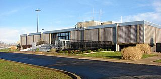
The Williamson County Courthouse is a government building in Marion, the county seat of Williamson County, Illinois, United States. Built in 1971, it is the fourth courthouse in Marion's history.