Interstate 65 (I-65) is a major north–south Interstate Highway in the central United States. As with most primary Interstates ending in 5, it is a major crosscountry, north–south route, connecting between the Great Lakes and the Gulf of Mexico. Its southern terminus is located at an interchange with I-10 in Mobile, Alabama, and its northern terminus is at an interchange with US 12 (US 12), and US 20 in Gary, Indiana, just southeast of Chicago. I-65 connects several major metropolitan areas in the Midwest and Southern US. It connects the four largest cities in Alabama: Mobile, Montgomery, Birmingham, and Huntsville. It also serves as one of the main north–south routes through Nashville, Tennessee; Louisville, Kentucky; and Indianapolis, Indiana, each a major metropolitan area in its respective state.

An exit number is a number assigned to a road junction, usually an exit from a freeway. It is usually marked on the same sign as the destinations of the exit. In some countries, such as the United States, it is also marked on a sign in the gore.
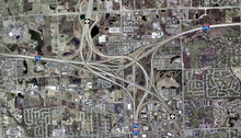
Interstate 580 (I-580) is an approximately 76-mile-long (122 km) east–west auxiliary Interstate Highway in Northern California. The heavily traveled spur route of I-80 runs from US Route 101 (US 101) in San Rafael in the San Francisco Bay Area to I-5 at a point outside the southern city limits of Tracy in the Central Valley. I-580 forms a concurrency with I-80 between Albany and Oakland, the latter of which is the location of the MacArthur Maze interchange immediately east of the San Francisco–Oakland Bay Bridge. I-580 provides a connection from the Bay Area to the southern San Joaquin Valley and Southern California via I-5, as I-5 bypasses the Bay Area to the east.
A frontage road is a local road running parallel to a higher-speed, limited-access road. A frontage road is often used to provide access to private driveways, shops, houses, industries or farms. Where parallel high-speed roads are provided as part of a major highway, these are also known as local lanes. Sometimes a similar arrangement is used for city roads; for example, the collector portion of Commonwealth Avenue in Boston, Massachusetts, is known as a carriage road.

Interstate 515 (I-515) is a 14.44-mile-long (23.24 km) spur route of I-15 in the US state of Nevada that runs from the junction of I-11, I-215, and State Route 564 (SR 564) at the Spaghetti Bowl Interchange in Henderson to the junction of I-15, U.S. Route 93 (US 93), and US 95 at the Las Vegas Spaghetti Bowl Interchange in Downtown Las Vegas. The freeway connects traffic headed from Boulder City and Henderson to Downtown Las Vegas via a direct, high-speed route, and it runs concurrently with, US 93, and US 95 along its entire length.

U.S. Route 65 is a north–south United States highway in the southern and midwestern United States. The southern terminus of the route is at U.S. Route 425 in Clayton, Louisiana. The northern terminus is at Interstate 35 just south of Interstate 90 in Albert Lea, Minnesota. Parts of its modern route in Iowa and historic route in Minnesota follow the old Jefferson Highway.

The median strip, central reservation, roadway median, or traffic median is the reserved area that separates opposing lanes of traffic on divided roadways such as divided highways, dual carriageways, freeways, and motorways. The term also applies to divided roadways other than highways, including some major streets in urban or suburban areas. The reserved area may simply be paved, but commonly it is adapted to other functions; for example, it may accommodate decorative landscaping, trees, a median barrier, or railway, rapid transit, light rail, or streetcar lines.
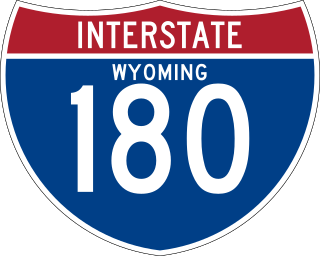
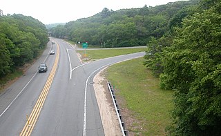
Interstate 180 (I-180) is a 1.09-mile-long (1.75 km) expressway in the US state of Wyoming between I-80 and downtown Cheyenne.

A limited-access road, known by various terms worldwide, including limited-access highway, dual-carriageway, expressway, and partial controlled-access highway, is a highway or arterial road for high-speed traffic which has many or most characteristics of a controlled-access highway, including limited or no access to adjacent property, some degree of separation of opposing traffic flow, use of grade separated interchanges to some extent, prohibition of slow modes of transport, such as bicycles, horse-drawn vehicles or ridden horses, or self-propelled agricultural machines; and very few or no intersecting cross-streets or level crossings. The degree of isolation from local traffic allowed varies between countries and regions. The precise definition of these terms varies by jurisdiction.

Interstate 580 (I-580) is a 35.019-mile (56.358 km) auxiliary Interstate Highway in Western Nevada. It runs concurrently with US Route 395 (US 395) from an intersection with US 50 near the southern boundary of Carson City to the Reno Spaghetti Bowl interchange with I-80 in Reno. The freeway provides a high-speed direct route between Lake Tahoe and Carson City to Reno and I-80.
Autoroute 15 is a highway in western Quebec, Canada. It was, until the extension of Autoroute 25 was opened in 2011, the only constructed north-south autoroute to go out of Montreal on both sides. A-15 begins at the end of Interstate 87 at the United States border at Saint-Bernard-de-Lacolle and extends via Montreal to Sainte-Agathe-des-Monts with an eventual continuation beyond Mont-Tremblant. The total length of A-15 is currently 164 km (101.9 mi), including a short concurrency with Autoroute 40 that connects the two main sections. This is one of the few autoroutes in Quebec that does not have any spinoff highways.

In the field of road transport, an interchange or a grade-separated junction is a road junction that uses grade separations to allow for the movement of traffic between two or more roadways or highways, using a system of interconnecting roadways to permit traffic on at least one of the routes to pass through the junction without interruption from crossing traffic streams. It differs from a standard intersection, where roads cross at grade. Interchanges are almost always used when at least one road is a controlled-access highway or a limited-access divided highway (expressway), though they are sometimes used at junctions between surface streets.

A controlled-access highway is a type of highway that has been designed for high-speed vehicular traffic, with all traffic flow—ingress and egress—regulated. Common English terms are freeway, motorway, and expressway. Other similar terms include throughway or thruway and parkway. Some of these may be limited-access highways, although this term can also refer to a class of highways with somewhat less isolation from other traffic.

State Route 132 is a state highway in the U.S. state of California that connects the Central Valley with the Sierra Nevada foothills and the California Gold Country. Its western segment also connects the city of Modesto with the San Francisco Bay Area via I-580, although this route is discouraged due to it being a two-lane road between Modesto and Interstate 5. East of Modesto, the road climbs the foothills and eventually ends at SR 49 at Coulterville.
A two-lane expressway or two-lane freeway is an expressway or freeway with only one lane in each direction, and usually no median barrier. It may be built that way because of constraints, or may be intended for expansion once traffic volumes rise. The term super two is often used by roadgeeks for this type of road, but traffic engineers use that term for a high-quality surface road. Most of these roads are not tolled.

U.S. Route 95 is a major U.S. highway traversing the U.S. state of Nevada from north to south directly through Las Vegas and providing connections to both Carson City and Reno. US 95 is cosigned with Interstate 80 for 95 miles (153 km) between a junction in Trinity and Winnemucca before heading north into Oregon at McDermitt. At 646.71 miles (1,040.78 km), it is the longest highway in Nevada.

U.S. Route 395 (US 395) is an 85-mile-long (137 km) United States Numbered Highway near Lake Tahoe in the state of Nevada. It traverses the state after entering from California in Topaz Lake and crosses back into California near Hallelujah Junction. US 395 serves the cities of Gardnerville, Minden, Carson City and Reno. All of US 395 north of Carson City is a freeway and is built up to Interstate Highway standards. Part of the freeway section is also designated as Interstate 580 (I-580). US 395 is an important regional highway, serving the communities of Western Nevada, connecting them to other major communities via California, and it is the only major north–south arterial for the geographically isolated region.
This article describes the highway systems available in selected countries.