Sparkhill

Last updated

Sparkhill Public Library Sparkhill Public Library.jpg
Sparkhill Public Library
The Bear public house, Holland W. Hobbiss & William Bloye The Bear, Sparkhill.jpg
The Bear public house, Holland W. Hobbiss & William Bloye

Sparkhill is an inner-city area of Birmingham, England, situated between Springfield, Hall Green and Sparkbrook.

Contents

Historically part of Worcestershire, Sparkhill once existed as a rural area with its main industry being agriculture until the 1880s.

History

The Sparke family

In the Middle Ages, the Sparke family farmed in the area, [1] although it can be posited that Sparkhill takes its name from Spark Brook, a small stream that flows from Moseley to the River Cole in Small Heath. It was, as the name suggests, a hill that was situated alongside the stream. The watercourse can be traced almost entirely along its length from source to where it joins the River Tame, although most of its tributaries are now culverted, and is a popular route for leisure walkers and cyclists. The only part where it cannot easily be followed is a short tunnel where it passes under the Grand Union Canal, very close to the old BSA motorcycle factory near Golden Hillock Road. Most of the route is accessible through Ackers Trust artificial ski slope and sports centre, which was built on BSA's old test track. This part of the route is still used for off-road cycling and similar pursuits. [2]

The Cherry Arbour

As a result of the Industrial Revolution which was causing Birmingham to expand, development of the area began. In the 1850s, a small area of land was bought by a building society and sold to separate developers who built houses for the working class. People who owned a property were entitled to vote and a campaigner for the working class vote was Joseph Sturge, a Birmingham manufacturer. As a result of his campaigning, a newly created street in the area was named after him. The architecture of the houses was varied due to the different developers. A centre began to develop for the area with its own pub, The Cherry Arbour.

In the late 1860s, developments appeared all over Sparkhill with the creation of long, straight streets forming a uniform pattern. The new houses were terraced with their own back garden, coal shed and lavatory. For the wealthy middle class, larger houses were built in a plot bounded by Stoney Lane, Alfred Road and Durham Road.

Annexation by Birmingham

St John's Church St John's Church, Sparkhill - geograph.org.uk - 2646784.jpg
St John's Church
A sculpture at Sparkhill Methodist Church Sparkhill Methodist Church.JPG
A sculpture at Sparkhill Methodist Church

Sparkhill was removed from Yardley and annexed by Birmingham in 1911 as part of the Greater Birmingham Act . Yardley also became a suburb of Birmingham in the same year. The former council house for Yardley District Council (built 1898–1902, architect Arthur Harrison) was converted into Sparkhill Library ( SP09238366 ) and opened on 19 January 1923. It is one of the earliest examples of double-glazed windows in a public building. Other buildings built for the district were a police station, magistrate's court and a fire station, which were all located next to the council house. St John's Church is the local Anglican Parish Church and the home of the charity Narthex Sparkhill. Designed by the famous Birmingham Architects Martin and Chamberlain, the church was built in 1888. A reredos in memory of Louisa Ryland was erected in the church after her death.

World War II

As a result of the nearby BSA factory being targeted, the area suffered from bombing in World War II, resulting in the loss of some houses, and their 1940s replacement (e.g. the houses at 180–190 Osborne Road). A memorial to those from the BSA works who died during the Second World War can be found in St John's Church.

Public houses

Another old landmark in Sparkhill is the Mermaid Inn, which has been the site of a pub since the 17th century. The building was converted into a Balti restaurant in the late 20th century; however, it was severely damaged by numerous fires in the 2000s decade. The building's art deco exterior decoration is by local sculptor William Bloye.

The Antelope, a former public house, Holland W. Hobbiss & William Bloye The Antelope, Sparkhill.jpg
The Antelope, a former public house, Holland W. Hobbiss & William Bloye
The Mermaid public house, damaged by fire The Mermaid, Sparkhill.jpg
The Mermaid public house, damaged by fire

Other pubs, the Bear and The Antelope, both designed by Holland W. Hobbiss, have sculpted pub signs by William Bloye. The Antelope was, in 2010, converted into a Pakistani restaurant known as "Hajees Spice".

Immigration

In the 20th century, the area became heavily influenced by migrants who settled in the area.[ citation needed ] The first wave of immigrants were of Irish descent. This has progressed to include Afro-Caribbeans, South Asians, and more recently Somalis. Moreover, in the last decade, migrants of Romanian descent have begun to settle in the area, mostly inhabiting terraced houses.[ citation needed ] It has a large population of ethnic minorities, mainly of South Asian origin, which is reflected by the number of Asian eateries in the area.[ citation needed ] As a result, Sparkhill has become a main centre in the "Balti Triangle" of Birmingham.

Notable residents of Sparkhill

The BBC sitcom Citizen Khan focuses on the life of Mr Khan and his family, Pakistani immigrants in the Sparkhill area, which it dubbed "The capital of British Pakistan" in the credits. The first series was broadcast from August 2012 with a new series each year; currently up to series 5 in 2016.

Related Research Articles

Balsall Heath is an inner-city area of Birmingham, West Midlands, England. It has a diverse cultural mix of people and is the location of the Balti Triangle.

<span class="mw-page-title-main">Balti (food)</span> Type of curry cooked and eaten in a thin, pressed-steel wok called a "balti bowl"

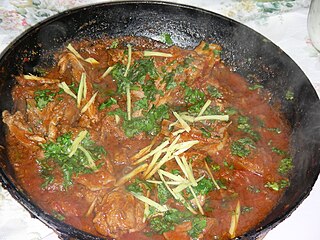
A balti or bāltī gosht is a type of curry served in a thin, pressed-steel wok called a "balti bowl". The name may have come from the metal dish in which the curry is cooked, rather than from any specific ingredient or cooking technique. Balti curries are cooked quickly using vegetable oil rather than ghee, over high heat in the manner of a stir-fry, and any meat is used off the bone. This combination differs sharply from a traditional one-pot Indian curry which is simmered slowly all day. Balti sauce is based on garlic and onions, with turmeric and garam masala, among other spices.

Sparkbrook is an inner-city area in south-east Birmingham, England. It is one of the four wards forming the Hall Green formal district within Birmingham City Council.

<span class="mw-page-title-main">Acocks Green</span> Human settlement in England

Acocks Green is a suburban area and ward of southeast Birmingham, England. It is named after the Acock family, who built a large house there in 1370. It is occasionally spelled "Acock's Green". It has frequently been noted on lists of unusual place names.

<span class="mw-page-title-main">Tividale</span> Human settlement in England

Tividale is a district of the Metropolitan Borough of Sandwell, West Midlands.

<span class="mw-page-title-main">Royal Small Arms Factory</span> Rifle factory in Enfield, London, 1816–1988

The Royal Small Arms Factory (RSAF), also known by the metonym Enfield, was a UK government-owned rifle factory in Enfield, adjoining the Lee Navigation in the Lea Valley. Some parts were in Waltham Abbey. The factory produced British military rifles, muskets and swords from 1816. It closed in 1988, but some of its work was transferred to other sites.

<span class="mw-page-title-main">Birmingham Sparkbrook and Small Heath (UK Parliament constituency)</span>

Birmingham, Sparkbrook and Small Heath was a parliamentary constituency represented in the House of Commons of the Parliament of the United Kingdom. It elected one Member of Parliament (MP) by the first-past-the-post system of election. The constituency was notable for having the largest percentage of Muslim voters of any UK constituency at 48.8%.

<span class="mw-page-title-main">Lozells</span> Inner-city area in West Birmingham, England

Lozells is a loosely defined inner-city area in West Birmingham, England. It is centred on Lozells Road, and is known for its multi-racial population. It is part of the ward of Lozells and East Handsworth and lies between the districts of Handsworth and Aston.

<span class="mw-page-title-main">Small Heath</span> Human settlement in England

Small Heath is an inner-city area in south-east Birmingham, West Midlands, England situated on and around the Coventry Road about 2 miles (3 km) from the city centre.

<span class="mw-page-title-main">2005 Birmingham tornado</span> Tornado in the United Kingdom in 2005

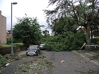
The 2005 Birmingham tornado was one of the strongest tornadoes recorded in Great Britain in nearly 30 years, occurring on 28 July 2005 in the suburbs of Birmingham. It formed on a day when thunderstorms were expected to develop across the Midlands and eastern England. The tornado struck at approximately 14:37 BST in the Sparkbrook area and also affected King's Heath, Moseley and Balsall Heath as it carved a 7 mile long path through the city.

Springfield is a ward in south east Birmingham, England, created in 2004 from much of the old Sparkhill ward. It is a part of the formal district of Hall Green.

<span class="mw-page-title-main">William Bidlake</span> British architect (1861–1938)

William Henry Bidlake MA, FRIBA was a British architect, a leading figure of the Arts and Crafts movement in Birmingham and Director of the School of Architecture at Birmingham School of Art from 1919 until 1924.

<span class="mw-page-title-main">Holland W. Hobbiss</span> English architect

Holland William Hobbiss, was an English architect in the Birmingham area. He traded under the names Holland W. Hobbiss and Partners and Holland W. Hobbiss and M. A. H. Hobbiss.

<span class="mw-page-title-main">Hay Mills</span> Human settlement in England

Hay Mills is an area of east Birmingham, England straddling the A45 Coventry Road about 3 miles (5 km) south east of the city centre. North of the Coventry Road is mainly residential whereas the south is mixed residential and commercial. The area was subsumed into Birmingham in 1911.

<span class="mw-page-title-main">Gilbertstone</span>

Gilbertstone is a residential suburban area straddling the border of Yardley and South Yardley in Birmingham, West Midlands.

<span class="mw-page-title-main">Warstock</span>

Warstock is a district within the city of Birmingham, UK, in the southernmost suburbs roughly 1 km east of the A435 and within the ward of Highter's Heath. The area lies within the B14 postcode and is contiguous with Yardley Wood to the north-east, Solihull Lodge to the south-east and Highter's Heath to the south-west. Kings Heath lies to the north-west.

<span class="mw-page-title-main">St John's Church, Sparkhill</span> Church in Birmingham, England

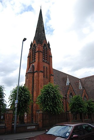
St John's Church is an Anglican church in Sparkhill Birmingham.

<span class="mw-page-title-main">The Antelope, Birmingham</span> Grade II listed building, formerly a pub, in Sparkhill, Birmingham, England

The Antelope, now housing a restaurant called Hajee's Spices, is a grade II listed building on the Stratford Road in Sparkhill, Birmingham, England. It opened as a public house called The Antelope in 1924.

References

  1. "Sparkbrook: History". 5 August 2010.
  2. "Sparkhill".

52°27′02″N1°51′51″W / 52.45046°N 1.86416°W / 52.45046; -1.86416