Related Research Articles

Dayton–Wright Brothers Airport is a public airport located 10 miles (16 km) south of the central business district of Dayton, Ohio, located mainly in Miami Township, Montgomery County and partly in Clearcreek Township, Warren County, near the suburb of Springboro. It is owned and operated by the City of Dayton and serves as the reliever airport for Dayton International Airport. It mainly serves corporate and personal aircraft users. The airport's identifying code, MGY, is a reference to its former name of Montgomery County Airport.

Ohio State University Airport is a public airport six miles (10 km) northwest of downtown Columbus, in Franklin County, Ohio, United States. It is owned and operated by Ohio State University in Columbus. It is also known as the OSU Don Scott Airport, named after Donald E. Scott, an OSU alumnus who died during his training as a pilot in the United Kingdom during World War II. The airport's main entrance is located on Case Road, and is easily accessible from OH-315 and Interstate 270.
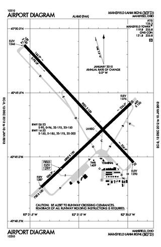
Mansfield Lahm Regional Airport is three miles (5 km) north of Mansfield, in Richland County, Ohio. By car the airport is an hour away from Cleveland and Columbus, near Interstate I-71, US Rt 30, State Route 13.
Ohio University Airport or Gordon K. Bush Airport, also known as Snyder Field, is a public-use airport located on State Route 32/U.S. 50 in the village of Albany, about ten miles (16 km) southwest of the city of Athens, in Athens County, Ohio, United States.
Portage County Airport, also known as Portage County Regional Airport, is a public use airport in Portage County, Ohio, United States. It is owned by the Portage County Airport Authority and located three nautical miles (6 km) north of Ravenna, in Shalersville Township. This airport is included in the National Plan of Integrated Airport Systems for 2011–2015, which categorized it as a general aviation facility.
Poplar Grove Airport is a small general aviation airport located in Poplar Grove, Illinois, United States. The airport was founded in 1972 as Belvidere Airport and renamed in 1994. It is located 3 miles south of Poplar Grove, and 3 miles north of Belvidere. The airport is privately owned and open to the public.

Union County Airport is a public use airport in Union County, Ohio, United States. It is owned by the Union County Airport Authority and located one nautical mile (2 km) southeast of the central business district of Marysville, Ohio. This airport is included in the National Plan of Integrated Airport Systems for 2011–2015, which categorized it as a general aviation facility.
Fairfield County Airport is a public use airport in Fairfield County, Ohio, United States. It is located three nautical miles (6 km) northwest of the central business district of Lancaster, the county seat. The airport is owned by the Fairfield County Commissioners.

Sault Ste. Marie Municipal Airport, also known as Sanderson Field, is a city-owned, public-use airport located one nautical mile (1.85 km) southwest of the central business district of Sault Ste. Marie, a city in Chippewa County, Michigan, United States.
Highland County Airport is a public-owned, public-use airport located at 9500 North Shore Drive three nautical mile (4.8 km) southeast of the central business district of the city of Hillsboro, in Highland County, Ohio, United States.
Paul C. Miller–Sparta Airport is a public airport located 3 mi (5 km) southeast of Sparta, Michigan. Established in 1941, the airport is currently owned and operated by the Village of Sparta and is self-supporting, requiring no public funding. It is included in the Federal Aviation Administration (FAA) National Plan of Integrated Airport Systems for 2017–2021, in which it is categorized as a regional general aviation facility.
Galion Municipal Airport is three miles northeast of Galion in Crawford County, Ohio. The FAA's National Plan of Integrated Airport Systems for 2009–2013 classified it as a general aviation airport.
Carroll County–Tolson Airport is a county–owned, public-use airport located one nautical mile (1.85 km) southeast of the central business district of Carrollton, a village in Carroll County, Ohio, United States. It is owned by the Carroll County Airport Authority. According to the FAA's National Plan of Integrated Airport Systems for 2009–2013, it is categorized as a general aviation airport.
Bluffton Airport is a public use airport located one nautical mile (1.85 km) southeast of the central business district of Bluffton, in Hancock County, Ohio, United States. It is owned by the Village of Bluffton. According to the FAA's National Plan of Integrated Airport Systems for 2009–2013, it is categorized as a general aviation facility.

Marion Municipal Airport is three miles northeast of Marion, in Marion County, Ohio. The FAA's National Plan of Integrated Airport Systems for 2011–2015 categorized it as a general aviation facility.
The Youngstown Elser Metro Airport is a privately owned, public use general aviation airport located 7 miles southwest of Youngstown in Beaver Township, Mahoning County, Ohio, United States. It has a 10/28 asphalt runway of 4,012 ft × 50 ft in dimension.
Holmes County Airport is a public airport located two miles southwest of Millersburg, Ohio, United States. It is owned and operated by the Holmes County Airport Authority.
The Picnkeyville/Du Quoin Airport is a civil, public use airport located 6 miles southeast of Pinckneyville and about 9 miles west of Du Quoin, Illinois, United States. The airport is publicly owned by the two cities.
Cottonwood Airport is a public use airport located two-mile (3.2 km) northwest of Rockford, Illinois. The airport is privately owned. The airport is one of multiple airports in Rockford; the city's main airport, located six miles (9.7 km) south of Cottonwood, is the Chicago/Rockford International Airport.
Ray Community Airport is a privately owned, public use airport located in Ray Township, Macomb County. Michigan. The airport sits on 93 acres of land at an elevation of 632 feet.
References
- 1 2 "FAA Information about Sparta Community Airport (SAR)". airport-data.com. Retrieved 2022-07-13.
- ↑ "Live video from Sparta Community Airport". FOX 2 Now. Retrieved 2022-07-13.
- ↑ Marquardt, Scott (June 22, 2017). "Sparta Community Airport Authority" (PDF). Sparta Community Airport. Retrieved June 19, 2023.
- ↑ "Sparta Community Airport begins construction on new hangar – North County News". www.northcountynews.org. Retrieved 2023-06-19.
- ↑ KHQA (2017-05-25). "Macomb Municipal Airport 1 of 6 to win 2017 Airport of the Year award". KHQA. Retrieved 2024-02-18.
- 1 2 "KSAR – Sparta Community Airport-Hunter Field – SkyVector". SkyVector. Retrieved 2022-07-13.
- ↑ "Sparta Community Airport-Hunter Field – KSAR – AOPA". Aircraft Owners and Pilots Association (AOPA). Retrieved 2022-07-13.
- ↑ "SPARTA COMMUNITY AIRPORT (SPARTA, IL) SAR OVERVIEW AND FBOS". FlightAware. Retrieved 2022-07-13.
- ↑ "AirNav: Sparta Aero Services". AirNav.com. Retrieved 2022-07-13.
- ↑ "Sparta Aero Services, Inc. FBO". FlightAware. Retrieved 2022-07-13.
- ↑ "Piper PA-J3-C65 crash in Illinois (N7744B) | PlaneCrashMap.com". planecrashmap.com. Retrieved 2023-12-09.
- ↑ "Accident Piper J3C-65 N7744B,". Aviation Safety Network. Flight Safety Foundation. Retrieved 2023-12-09.
- ↑ "Beech A36 crash in Illinois (N7253Z) | PlaneCrashMap.com". planecrashmap.com. Retrieved 2023-12-09.
- ↑ "Accident Beechcraft A36 Bonanza N7253Z,". aviation-safety.net. Retrieved 2023-12-09.
- ↑ "Cessna 182C crash in Illinois (N8643T) | PlaneCrashMap.com". planecrashmap.com. Retrieved 2023-12-09.
- ↑ "Accident Cessna 182C N8643T,". Aviation Safety Network. Flight Safety Foundation. Retrieved 2023-12-09.