Sperryville, Virginia

Last updated

Sperryville
Sperryville VA.jpg
A view from Sperryville Pike
Sperryville CDP in Rappahannock County.svg
Location of the Sperryville CDP within Rappahannock County
USA Virginia location map.svg
Red pog.svg
Sperryville
Location within the Commonwealth of Virginia
Usa edcp location map.svg
Red pog.svg
Sperryville
Sperryville (the United States)
Coordinates: 38°39′25″N78°13′34″W / 38.65694°N 78.22611°W / 38.65694; -78.22611
CountryUnited States
State Virginia
County Rappahannock
Elevation
700 ft (200 m)
Population
 (2010)
  Total342
Time zone UTC−5 (Eastern (EST))
  Summer (DST) UTC−4 (EDT)
ZIP codes
22740
Area code 540

Sperryville is a census-designated place (CDP) located in the western section of Rappahannock County, Virginia, United States, near Shenandoah National Park. It consists of a village with two main streets along the two branches of the Thornton River, together with surrounding pasture- and farmland. [1] The population as of the 2010 Census was 342. [2]

Contents

Climate

Sperryville has a warm temperate hot summer climate (Cfa), where the winters are cool, and summers are hot. The town is situated in USDA Hardiness Zone 7a, where the annual average minimum is 0 °F. It has four seasons: winter, spring, summer and fall. Cool-hardy crops and other plants such as peas and dandelions come about in mid to late March, and they stop growing in mid November.

Climate data for Sperryville, Virginia (1991–2020 normals, extremes 1995–present)
MonthJanFebMarAprMayJunJulAugSepOctNovDecYear
Record high °F (°C)80
(27)
83
(28)
88
(31)
94
(34)
96
(36)
100
(38)
104
(40)
101
(38)
99
(37)
92
(33)
84
(29)
81
(27)
104
(40)
Mean daily maximum °F (°C)43.1
(6.2)
46.9
(8.3)
54.1
(12.3)
65.3
(18.5)
72.9
(22.7)
81.2
(27.3)
85.2
(29.6)
83.8
(28.8)
77.3
(25.2)
67.2
(19.6)
56.9
(13.8)
46.6
(8.1)
65.0
(18.4)
Daily mean °F (°C)33.7
(0.9)
36.2
(2.3)
42.6
(5.9)
53.2
(11.8)
61.6
(16.4)
70.1
(21.2)
74.4
(23.6)
73.0
(22.8)
66.5
(19.2)
55.6
(13.1)
45.9
(7.7)
37.3
(2.9)
54.2
(12.3)
Mean daily minimum °F (°C)24.3
(−4.3)
25.5
(−3.6)
31.1
(−0.5)
41.1
(5.1)
50.2
(10.1)
59.0
(15.0)
63.6
(17.6)
62.2
(16.8)
55.7
(13.2)
44.0
(6.7)
35.0
(1.7)
28.1
(−2.2)
43.3
(6.3)
Record low °F (°C)−2
(−19)
−8
(−22)
3
(−16)
21
(−6)
29
(−2)
42
(6)
49
(9)
50
(10)
38
(3)
27
(−3)
12
(−11)
4
(−16)
−8
(−22)
Average precipitation inches (mm)3.61
(92)
2.77
(70)
4.01
(102)
4.01
(102)
4.67
(119)
5.21
(132)
3.67
(93)
4.12
(105)
5.44
(138)
3.68
(93)
3.69
(94)
3.96
(101)
48.84
(1,241)
Average snowfall inches (cm)6.9
(18)
6.9
(18)
1.9
(4.8)
0.2
(0.51)
0.0
(0.0)
0.0
(0.0)
0.0
(0.0)
0.0
(0.0)
0.0
(0.0)
trace0.3
(0.76)
4.8
(12)
21.0
(53)
Average precipitation days (≥ 0.01 in)10.49.110.512.114.511.911.011.010.18.98.110.4128.0
Average snowy days (≥ 0.1 in)3.23.41.70.10.00.00.00.00.00.10.42.311.2
Source: NOAA [3] [4]

History

The land on which Sperryville is located is part of 3,000 acres granted by King George II of Great Britain to Francis Thornton in 1731. [5]   This land was regranted to Thornton in 1751 by Thomas Fairfax, 6th Lord Fairfax of Cameron, owner of the Northern Neck Proprietary, after Fairfax won his suit to prevent the king from granting land in the Proprietary. [6] Part of this land was inherited by a descendant, also named Francis Thornton, in 1817. [7] He was a soldier in the War of 1812, became a Presbyterian minister, and was sent from his home in Fredericksburg, Virginia, to organize a Presbyterian church in what was then western Culpeper County. [8] In 1820 he began selling small lots of land along the main road (currently Main Street, VA Route 1001). The first deed was for a ½-acre lot “in a little town laid off by me, the said Francis Thornton Jr., and surveyed by Johnston Menefee … the village is in a flat adjoining the lands of John Menefee between the Pass Mill (today’s Fletcher’s Mill) and Thornton’s Gap.” [9] The village of Sperryville is named on an 1821 map of Culpeper County created by John Wood. [10]

On one of the lots, John Hopkins established an ‘ordinary’ that later became a boarding house for immigrant Irish laborers. On another lot was a tavern and stage coach office to serve people traveling from Culpeper Court House to New Market, Virginia. On other lots were a cobbler’s shop, stores, and individual homes. In the early 1800s John Kiger built Conestoga wagons in the area. The post office was established in the village in 1840. In the 1850s several turnpikes were constructed that accessed Sperryville: Thornton’s Gap from Culpeper to Sperryville, Newmarket & Sperryville, and Sperryville-Rappahannock from Sperryville east to the Rappahannock River. A tannery and worker’s homes were constructed in the late 1860s by the Smoot family.  Four churches were established in the area by 1880, as well as a woolen mill, seven distillers, two hotels, four general stores, and one saloon.  There were also ten corn and flour mills nearby. An apple processing facility was built in 1918 to serve the many local apple orchardists. Sperryville high school was constructed adjacent to the town. In the 1930s, a Civilian Conservation Corps camp located at Beech Spring west of the village provided farmers with a nearby market for produce, meat, milk, and eggs to feed the corpsmen housed there.  The Sperryville apple packing and juice plant was created on the site of the former Smoot tannery. [11] [12] [13] [14]

The Sperryville Historic District was listed on the Virginia Landmarks Registry in 1982 [15] and on the National Register of Historic Places in 1983. [16]

US Post office in Sperryville Post office in Sperryville.jpg
US Post office in Sperryville

Attractions

Sperryville continued as a small rural town with modest amenities until the opening of Skyline Drive in the late 1930s. The area became saturated with gasoline stations, roadside businesses, lunch rooms, restaurants, and motels. Modern Sperryville continues to cater to tourists and locals alike, but has reinvented itself with chic restaurants, bars, artisan shops, artist studios, bed and breakfast accommodations, and antique stores. The village and its environs also have wineries, a brewery, a distillery, and a 9-hole golf course. Roadside stands have given way to family farm and community-supported agricultural markets. Many homes and the schoolhouse have been repurposed into commercial ventures. The annual Sperryfest celebrates the vibrant community. [17] [18] [19]

The village is located at the foothills of the Blue Ridge mountains and, via U.S. Route 211, provides access to the Thornton Gap entrance of Shenandoah National Park and Skyline Drive. Popular nearby hiking trails in the Park include the Buck Hollow/Buck Ridge trail, Thornton River trail, White Oak Canyon, and Old Rag Mountain. [20] [21] [22]

Pen Druid is a brewery offering beer, wine, and cider. Washingtonian magazine said, “The Carney brothers opened the Pen Druid brewery in August 2015. In the years since, they’ve built a reputation for their low-intervention, terroir-driven method of brewing—the same processes in the natural wine craze—to make beer ‘that tastes like it’s from a place,’ Van says. Taking cues from traditional German and Czech breweries, the Carney brothers use wood-fired kettles and a mix of wild and open fermentation with native yeasts to age brews up to three years.” [23]

Welcome to Sperryville mural painted at Happy Camper Equipment Co. in 2018 The Welcome to Sperryville Mural.jpg
Welcome to Sperryville mural painted at Happy Camper Equipment Co. in 2018

In 2018, Happy Camper Equipment Co., situated at one entrance to historic Main Street, painted a mural reading "Welcome to Sperryville" on a side of the building that has become a point of pride in the community and a local attraction. [24]

Sperryville is the setting for parts of the 8th Jack Reacher novel, The Enemy, by Lee Child.

Further reading

Related Research Articles

<span class="mw-page-title-main">Warren County, Virginia</span> County in Virginia, United States

Warren County is a U.S. county located in the Commonwealth of Virginia. The 2020 census places Warren County within the Washington-Arlington-Alexandria, DC-VA-MD-WV Metropolitan Statistical Area with a population of 40,727. The county was established in 1836. The county seat is Front Royal.

<span class="mw-page-title-main">Rappahannock County, Virginia</span> County in Virginia, United States

Rappahannock County is a county located in the northern Piedmont region of the Commonwealth of Virginia, US, adjacent to Shenandoah National Park. As of the 2020 Census, the population was 7,348. Its county seat is Washington. The name "Rappahannock" comes from the Algonquian word lappihanne, meaning "river of quick, rising water" or "where the tide ebbs and flows." The county is included in the Washington-Arlington-Alexandria, DC-VA-MD-WV Metropolitan Statistical Area.

<span class="mw-page-title-main">Culpeper County, Virginia</span> County in Virginia, United States

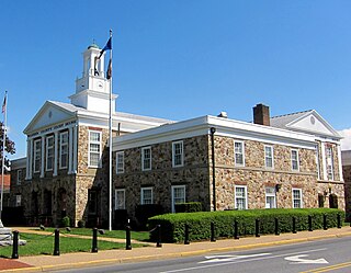
Culpeper County is a county located along the borderlands of the northern and central region of the Commonwealth of Virginia. As of the 2020 United States Census, the population was 52,552. Its county seat and only incorporated community is Culpeper.

<span class="mw-page-title-main">Washington, Virginia</span> Town in Virginia

The town of Washington, Virginia, is a historic village located in the eastern foothills of the Blue Ridge Mountains near Shenandoah National Park. The entire town is listed on the National Register of Historic Places as a historic district, Washington Historic District. It is the county seat of Rappahannock County, Virginia.

<span class="mw-page-title-main">Northern Neck</span> Region in Virginia, United States

The Northern Neck is the northernmost of three peninsulas on the western shore of the Chesapeake Bay in the Commonwealth of Virginia. The Potomac River forms the northern boundary of the peninsula; the Rappahannock River demarcates it on the south. The land between these rivers was formed into Northumberland County in 1648, prior to the creation of Westmoreland County and Lancaster County. The Northern Neck encompasses the following Virginia counties: Lancaster, Northumberland, Richmond, King George and Westmoreland; it had a total population of 50,158 as of the 2020 census.

<span class="mw-page-title-main">U.S. Route 211</span> Highway in the United States

U.S. Route 211 is a spur of US 11 in the U.S. state of Virginia. Known for most of its length as Lee Highway, the U.S. Highway runs 59.09 miles (95.10 km) from Interstate 81 (I-81) and Virginia State Route 211 in New Market east to US 15 Business, US 29 Business, and US 211 Business in Warrenton. US 211 connects the Shenandoah Valley with the Piedmont town of Warrenton via Luray and Sperryville, where the highway runs concurrently with US 340 and US 522, respectively.

<span class="mw-page-title-main">U.S. Route 522</span> Highway in the United States

U.S. Route 522 is a spur route of US 22 in the states of Virginia, West Virginia, Maryland, and Pennsylvania. The U.S. Highway travels in a north-south direction, and runs 308.59 miles (496.63 km) from US 60 near Powhatan, Virginia, to its northern terminus at US 11 and US 15 near Selinsgrove, Pennsylvania. US 522 serves many small cities and towns in the Piedmont, Blue Ridge Mountains, and northern Shenandoah Valley of Virginia. The highway serves the Virginia communities of Goochland, Mineral, Culpeper, the town of Washington, and Front Royal and the independent city of Winchester. US 522 then follows the Ridge-and-Valley Appalachians north and then east through the Eastern Panhandle of West Virginia, a 2-mile-wide (3.2 km) stretch of Western Maryland, and South Central Pennsylvania to its terminus in the Susquehanna Valley. The highway serves Berkeley Springs, West Virginia; Hancock, Maryland; and the Pennsylvania communities of McConnellsburg, Mount Union, Lewistown, and Middleburg.

<span class="mw-page-title-main">Rapidan River</span>

The Rapidan River, flowing 88 miles (142 km) through north-central Virginia in the United States, is the largest tributary of the Rappahannock River. The two rivers converge just west of the city of Fredericksburg. The Rapidan River begins west of Doubletop Mountain in Shenandoah National Park where the Mill Prong meets the Laurel Prong at Rapidan Camp, approximately 3 miles (4.8 km) south of Big Meadows. The river defines the border of Orange County with Culpeper and Madison Counties.

<span class="mw-page-title-main">Amissville, Virginia</span> Unincorporated community in Virginia, United States

Amissville is an unincorporated community in Rappahannock County in the U.S. commonwealth of Virginia. It is located on U.S. Route 211 about halfway between Warrenton and the small town of Washington, Virginia.

<span class="mw-page-title-main">Thornton Gap</span>

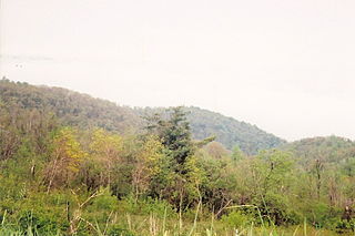
Thornton Gap is a wind gap located in the Blue Ridge Mountains in Virginia separating the Shenandoah Valley from the Piedmont region of the state.

<span class="mw-page-title-main">Virginia State Route 3</span> State highway in central Virginia, US

Virginia State Route 3 is a primary state highway in the U.S. state of Virginia that extends from the town of Culpeper south and eastwardly to Gloucester in Virginia's Middle Peninsula region. For many years, a portion was named "Historyland Highway".

<span class="mw-page-title-main">National Register of Historic Places listings in Virginia</span>

Buildings, sites, districts, and objects in Virginia listed on the National Register of Historic Places:

<span class="mw-page-title-main">Virginia State Route 231</span> State highway in Virginia, United States

State Route 231 is a primary state highway in the U.S. state of Virginia. The state highway runs 49.82 miles (80.18 km) from SR 22 in Cismont north to U.S. Route 522 near Sperryville. SR 231 forms part of the connection between Charlottesville and Gordonsville, where the highway meets US 15 and US 33. The state highway also serves as the main north–south highway of Madison County, connecting the county seat of Madison, where the highway intersects US 29, with Gordonsville to the south and passing through the foothills of the Blue Ridge Mountains to the north.

Aylett Hawes was a nineteenth-century doctor, politician, planter and slaveholder from Virginia.

<span class="mw-page-title-main">Fairfax Line</span> Surveyors line

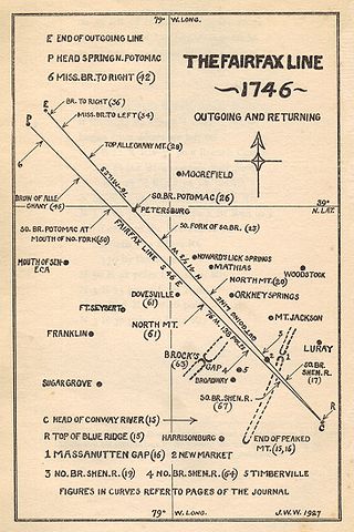
The Fairfax Line was a surveyor's line run in 1746 to establish the limits of the "Northern Neck land grant" in colonial Virginia.

<span class="mw-page-title-main">Thornton River</span>

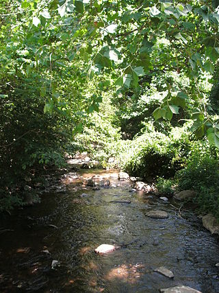
The Thornton River is a 27.9-mile-long (44.9 km) river in the U.S. state of Virginia. It rises at Thornton Gap in Shenandoah National Park and flows east through Rappahannock County, running parallel to U.S. Route 211 until it reaches the town of Sperryville. Continuing east into Culpeper County, the Thornton River joins the Hazel River, a tributary of the Rappahannock River, and thus part of the Chesapeake Bay watershed.

<span class="mw-page-title-main">Sperryville Historic District</span> Historic district in Virginia, United States

Sperryville Historic District is a national historic district located at Sperryville, Rappahannock County, Virginia, USA. It encompasses 63 contributing buildings in the village of Sperryville. The buildings are predominantly wood-frame, one-and two-story residences, some of which have been converted to commercial establishments. They include a collection of former factory workers' housing built to serve the workers of the Smoot tannery from 1867 to the early 20th century. A number of the buildings were constructed after 1850 with ornamentation and board-and-batten siding that is suggestive of the mid-century Romantic Revivals. Notable buildings include the George William Cooper House, the Dr. Amiss House, the Hopkins Ordinary, and the Totten's Mill House.

William Beverley (1696–1756) was an 18th-century legislator, civil servant, planter and landowner in the Colony of Virginia. Born in Virginia, Beverley—the son of planter and historian Robert Beverley, Jr. and his wife, Ursula Byrd Beverley (1681–1698)—was the scion of two prominent Virginia families. He was the nephew of Peter Beverley (1668–1728), Speaker of the Virginia House of Burgesses, and the grandson of wealthy Virginia planter William Byrd I (1652–1704) of Westover Plantation. Beverley's mother died shortly before her 17th birthday, and he was sent to England.

Jonathan Catlett Gibson, Jr. was a nineteenth-century Virginia lawyer, farmer and Confederate soldier who represented Fauquier County in the Virginia Constitutional Convention of 1868 and later Culpeper County in the Virginia House of Delegates.

References

  1. "Get to Know Rappahannock". County of Rappahannock. Retrieved April 5, 2011.
  2. Virginia Trend Report 2: State and Complete Places (Sub-state 2010 Census Data). Missouri Census Data Center. Accessed 2011-06-08.
  3. "NOWData - NOAA Online Weather Data". National Oceanic and Atmospheric Administration. Retrieved October 14, 2023.
  4. "Summary of Monthly Normals 1991-2020". National Oceanic and Atmospheric Administration. Retrieved October 14, 2023.
  5. Virginia Colonial Land Office Patent Book 15, pp. 154-155, Library of Virginia, Richmond
  6. Northern Neck Grants Book H, pp. 55-57, Library of Virginia, Richmond
  7. Will Book H, p. 43, Office of the Culpeper County, Virginia, Court Clerk
  8. Maureen Harris, “Will the Real Francis Thornton Please Stand Up,” Rappahannock News, July 2, 2015, pp. B1-B2, https://www.rappnews.com/features/will-the-real-francis-thornton-please-stand-up/article_7942c821-0128-5a99-b284-cfd3a1a53854.html
  9. Deed Book LL, p. 404, Office of the Culpeper County, Virginia, Court Clerk
  10. Elisabeth B. and C.E. Johnson, Rappahannock County, Virginia, A History, Green Publishers, Orange, Virginia, 1981, pp. 20-21
  11. Mildred Saunders Hofer, 1850 Federal Census of Rappahannock County, Virginia, Keuffel & Esser Co., Arlington, Virginia
  12. Scott Arnold, A Guidebook to Virginia’s Historical Markers, University Press of Virginia, Charlottesville, 2007, p. 73
  13. Elisabeth B. and C.E. Johnson, Rappahannock County, Virginia, A History, Green Publishers, Orange, Virginia, 1981, pp.129-134, 304-317
  14. Hite, Mary (1950). My Rappahannock (Virginia) Story Book. Richmond, Virginia: The Dietz Press Incorporated. pp. 143–145.
  15. "078-0093 Sperryville Historic District".
  16. "National Register Database and Research - National Register of Historic Places (U.S. National Park Service)".
  17. "This Lovely, Little Known Town in Virginia is Positively Delightful". February 5, 2018.
  18. https://www.virginia.org/cities/Sperryville [ dead link ]
  19. "Welcome to Sperryville, Virginia!". Welcome to Sperryville, Virginia!. Retrieved June 23, 2021.
  20. "Buck Hollow Trail and Buck Ridge Trail Loop".
  21. "Thornton River Lower Trail Hiking Trail, Washington, Virginia".
  22. https://www.nps.gov/shen/plan-your-visit/maps.htm [ dead link ]
  23. Oh, Brian (October 8, 2020). "'Leaf Peeping in Shenandoah? These Wild-Fermented Beers Are Worth a Pit Stop'". Washingtonian.
  24. McCaslin, John (July 2018). "'Welcome to Sperryville' creator petitions BOS for additional murals in county". Rappahannock News. Retrieved March 20, 2020.