Related Research Articles

Glenwood Springs is a home rule municipality that is the county seat of Garfield County, Colorado, United States. The city population was 9,963 at the 2020 United States Census. Glenwood Springs is located at the confluence of the Roaring Fork River and the Colorado River, connecting the Roaring Fork Valley and a series of smaller towns up and down the Colorado River.

Blanchard Springs Caverns is a cave system located in the Ozark–St. Francis National Forest in Stone County in northern Arkansas, USA, 2 miles (3.2 km) off Highway 14 a short distance north of Mountain View. It is the only tourist cave owned by the United States Forest Service and the only one owned by the federal government outside the National Park System. Blanchard Springs Caverns is a three-level cave system, all of which can be viewed on guided tours.
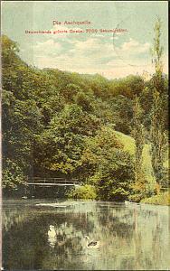
The Aachtopf is Germany's biggest karst spring, south of the western end of the Swabian Jura near the town of Aach. It produces an average of 8,500 litres per second. Most of the water stems from the River Danube where it disappears underground at the Danube Sinkhole, 12 kilometres (7.5 mi) north near Immendingen and about 14 kilometres (8.7 mi) north near Fridingen. The cave system has been explored since the 1960s, but as of 2020 only a small part has been discovered due to a large blockage after a few hundred metres.

The Paklenica karst river canyon is a national park in Croatia. It is near Starigrad, northern Dalmatia, on the southern slopes of Velebit mountain, not far from Zadar. It contains two canyons, Mala (Small) and Velika (Big) Paklenica. Today there is no water flowing through Mala Paklenica. Near the entrance to the Velika Paklenica is an artificial tunnel complex built for Josip Broz Tito during the tension between Yugoslavia and the USSR in the late 1940s and early 1950s.

A cenote is a natural pit, or sinkhole, resulting from the collapse of limestone bedrock that exposes groundwater. The term originated on the Yucatán Peninsula of Mexico, where cenotes were commonly used for water supplies by the ancient Maya, and occasionally for sacrificial offerings. The term derives from a word used by the lowland Yucatec Maya—tsʼonoʼot—to refer to any location with accessible groundwater.

Fall Creek Falls State Resort Park is a state park in Van Buren and Bledsoe counties, in the U.S. state of Tennessee. The over 30,638-acre (123.99 km2) park is centered on the upper Cane Creek Gorge, an area known for its unique geological formations and scenic waterfalls. The park's namesake is the 256-foot (78 m) Fall Creek Falls, the highest free-fall waterfall east of the Mississippi River.

Rock Island State Park is a state park in Warren County and White County, Tennessee, located in the Southeastern United States. The park is named after the community of Rock Island, Tennessee, which in turn received its name from an island on the Caney Fork upstream from the Collins River confluence and Great Falls Dam. Rock Island State Park is centered on a peninsula created by the confluence of these two rivers and extends downstream to the headwaters of Center Hill Lake.

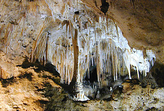
Craighead Caverns is an extensive cave system located in between Sweetwater and Madisonville, Tennessee. It is best known for containing the United States' largest and the world's second largest non-subglacial underground lake, The Lost Sea. In addition to the lake, the caverns contain an abundance of crystal clusters called anthodites, stalactites, stalagmites, and a waterfall.

Manatee Springs State Park is a Florida State Park located six miles west of Chiefland on SR 320, off US 19. Manatee Spring is a first magnitude spring that flows directly into the Suwannee River by way of a short run. Present also are swamps and hardwood wetlands along the Suwannee, along with many sinkhole ponds, including one with a cave 90 feet below the ground that connects to a popular divers' destination known as the catfish hotel.

Dos Ojos is part of a flooded cave system located north of Tulum, on the Caribbean coast of the Yucatán Peninsula, in the state of Quintana Roo, Mexico. The exploration of Dos Ojos began in 1987 and still continues. The surveyed extent of the cave system is 82 kilometers (51 mi) and there are 28 known sinkhole entrances, which are locally called cenotes. In January 2018, a connection was found between Sistema Dos Ojos and Sistema Sac Actun. The smaller Dos Ojos became a part of Sac Actun, making the Sistema Sac Actun the longest known underwater cave system in the world.
Glenwood Caverns Adventure Park is an adventure park located above Glenwood Springs, Colorado, about 160 mi (260 km) west of Denver. Prior to 2003, only cave tours were available until a major expansion took place. The park is unique because it sits at an altitude of 7,100 ft (2,200 m) on a mountain above Glenwood Springs. Today, the park features numerous attractions in addition to the cave tours.

The Blauhöhle is the largest cave system in the Swabian Alps in southern Germany. The Blauhöhle presumably originated in a time when the Danube still flowed through the Blau valley. Since the shifting of the Danube, several small rivers, the Schmiech, the Ach, and the Blau, have flowed through this valley. The cave system begins about 21 meters under water at the base of the Blautopf. It continues west and northwest, rising and falling several times until after a horizontal distance of about 1,200 metres (3,900 ft) it comes above the level of ground water and opens into the second big air-filled chamber. The maximum depth of the cave under water is 42 metres (138 ft).
Carlsbad Caverns National Park is an American national park in the Guadalupe Mountains of southeastern New Mexico. The primary attraction of the park is the show cave Carlsbad Cavern. Visitors to the cave can hike in on their own via the natural entrance or take an elevator from the visitor center.

Germany Valley is a scenic upland valley high in the Allegheny Mountains of eastern West Virginia originally settled by German farmers in the mid-18th century. It is today a part of the Spruce Knob–Seneca Rocks National Recreation Area of the Monongahela National Forest, although much ownership of the Valley remains in private hands.
Tytoona Cave is located approximately 1-mile (1.6 km) from Arch Springs, Pennsylvania in Sinking Valley, near Tyrone and Altoona, in the United States.

Scott's Gulf is a canyon situated along the Caney Fork River in White County, Tennessee, in the southeastern United States. The canyon stretches for approximately 18 miles (29 km) as the Caney Fork drops from the top of the Cumberland Plateau down to the eastern Highland Rim. This remote section of the river is home to a wilderness area consisting of a largely undisturbed deciduous forest, numerous waterfalls, caves and other geological formations, and Class IV and Class V whitewater rapids.
The Lost River is a river that rises in Vernon Township, Washington County, Indiana, and discharges into the East Fork of the White River in Lost River Township, Martin County, Indiana. The river's unusual hydrology has led to two of its features being named as National Natural Landmarks.
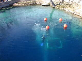
The Blue Hole of Santa Rosa, or simply the Blue Hole, is a circular, bell-shaped pool or small lake located along Route 66 east of Santa Rosa, New Mexico that is a tourist attraction and swimming venue, and one of the most popular dive destinations in the US for scuba diving and training. The Blue Hole is an artesian well and cenote that was once used as a fish hatchery.
The Grutas de Cacahuamilpa National Park in Guerrero, Mexico, is best known for the Grutas de Cacahuamilpa Caverns. It is also home to the Grutas of Carlos Pacheco, a smaller system, as well as two subterranean rivers which have carved out tunnels in the rock. The park has outdoor pursuit attractions such as rappelling, and rock climbing in Limontitla Canyon. as well as the two underground rivers to explore. It also has a small botanical garden, a pool and places to camp.

Cave diving is underwater diving in water-filled caves. The equipment used varies depending on the circumstances, and ranges from breath hold to surface supplied, but almost all cave diving is done using scuba equipment, often in specialised configurations with redundancies such as sidemount or backmounted twinset. Recreational cave diving is generally considered to be a type of technical diving due to the lack of a free surface during large parts of the dive, and often involves planned decompression stops. A distinction is made by recreational diver training agencies between cave diving and cavern diving, where cavern diving is deemed to be diving in those parts of a cave where the exit to open water can be seen by natural light. An arbitrary distance limit to the open water surface may also be specified. Despite the risks, water-filled caves attract scuba divers, cavers, and speleologists due to their often unexplored nature, and present divers with a technical diving challenge.
References
- ↑ "Spring Cave Trail #1834". fs.usda.gov. Archived from the original on 2014-08-11.