
Blanchard Springs Caverns is a cave system located in the Ozark–St. Francis National Forest in Stone County in northern Arkansas, 2 miles off Highway 14 a short distance north of Mountain View. It is the only tourist cave owned by the United States Forest Service and the only one owned by the Federal government outside the National Park System. Blanchard Springs Caverns is a three-level cave system, all of which can be viewed on guided tours. The Dripstone Trail runs through the uppermost level of caverns for about a half-mile and opened in 1973. The Discovery Trail opened in 1977 and loops through a 1.2-mile section of the cavern, descending to the lower level of the cave, 366 feet underground, as well as to the Natural Entrance, about 100 feet below ground at that point, following the stream bed of the springs that created the cavern. This trail includes the Rimstone Dams, which create pools along the stream bed, and the Ghost Room, a small but very well decorated room in the uppermost level, with its huge white flowstone. Also offered is a "Wild Cave" tour which allows access to undeveloped parts of the cave to more adventurous visitors. It follows the upstream section of the cave, allowing visitors to see all three levels as the original explorers did, continuing beyond where the Discovery Trail ends.

Bluespring Caverns is a cave system located in Lawrence County, Indiana, approximately 80 miles (128 km) south of Indianapolis. The cave system is a karst and river type cave formation and drains a 15 miles² (38.8 km²) sinkhole plain. The cave contains 21 miles (34 km) of surveyed passages and is most notable for having the longest known subterranean river in the United States with approximately 3 miles (4.8 km) of navigable river.

Cave of the Winds is a cave in the Pikes Peak region of Colorado. It is located just west of Colorado Springs on U.S. Highway 24, near the Manitou Cliff Dwellings. Tours of the complex of caves are given daily.
Mystic Caverns and Crystal Dome are show caves located between the cities of Jasper and Harrison, in the state of Arkansas, U.S., on the Arkansas Highway 7 Scenic Byway near the defunct amusement park Dogpatch USA. Sometimes called "the twin caves" because they are within 400 feet (120 m) of each other, the two caves maintain a year-round temperature of 58 °F, contain more formations per foot than any other caves in Arkansas, and are open for public tours year-round except during the January flooding season.

Marengo Cave is a privately owned cave located in Marengo, Indiana. One of only four show caves in Indiana, public tours of the cave have been given since 1883. Tours commenced just days after the cave's discovery by two school children. The cave was designated as a National Natural Landmark in 1984.

The Howe Caverns is a cave in Howes Cave, Schoharie County, New York. Howe Caverns is a popular tourist attraction, providing cave-goers with a sense of caving or spelunking, without needing the advanced equipment and training usually associated with such adventures.

DeSoto Caverns is a series of caves and a tourist attraction located in Childersburg, Talladega County, Alabama. Located in the foothills of the Appalachian Mountains, it is touted as "Alabama's Big Cave". In addition to the caves, the park offers various other attractions, including a three-quarter acre maze known as the Lost Trail Maze, panning for gemstones, a climbing wall, and amusement park style rides. While on the caverns tour, visitors can view a sound, light, and water show that changes with the holidays and seasons.

Moaning Caverns is a solutional cave located in the Calaveras County, California, near Vallecito, California in the heart of the state's Gold Country. It is developed in marble of the Calaveras Formation. It was discovered in modern times by gold miners in 1851, but it has long been known as an interesting geological feature by prehistoric peoples. It gets its name from the moaning sound that echoed out of the cave luring people to the entrance, however expansion of the opening to allow access for the public disrupted the sounds. The portion of the cave developed for tourists consists of a spacious vertical shaft 165 feet tall, which is descended by a combination of stairs and a unique 100-foot-high (30 m) spiral staircase built in the early 1900s. It is open to the public for walking tours and spelunking. Including the off-trail areas, the cave reaches a depth of 410 feet.

Squire Maugridge Boone Jr. was an American frontiersman, longhunter, soldier, city planner, politician, land locator, judge, politician, gunsmith, miller, and brother of Daniel Boone. In 1780, he founded the first settlement in Shelby County, Kentucky. The tenth of eleven children, Squire Boone was born to Squire Boone Sr. and his wife Sarah (Morgan) Boone in Berks County, Pennsylvania, at the Daniel Boone Homestead. Although overshadowed by his famous brother, Squire Boone was well known in his day.

Lost River Cave is a seven-mile cave system located in Bowling Green, Kentucky. The Lost River originates outside of the cave and flows into it. The cave contains one of the largest natural entrances in the Eastern U.S. Boat tours are available year-round, but closed for Thanksgiving Day, Christmas Eve, Christmas Day, and New Year's Day. The river was once listed by Ripley's Believe it or Not as the "Shortest, deepest river in the world" because the blue hole is over 437 feet deep, while the river itself is only 400 feet long. In fact, the blue hole is only 16 feet deep, but is linked to a further underground river. The 72-acre cave property is jointly owned by Western Kentucky University and the non-profit Friends of Lost River Cave.
Poldark Mine is a tourist attraction near the town of Helston in Cornwall, England, UK. It lies within the Wendron Mining District of the Cornwall and West Devon Mining Landscape World Heritage Site. Its features include underground guided tours through ancient tin mine workings, a museum of industrial heritage, mining equipment and Cornish social history, a scheduled ancient monument and riverside gardens.

Onondaga Cave State Park is a Missouri state park located on the Meramec River approximately 5 miles (8.0 km) southeast of the village of Leasburg. The park was established in 1982. Park activities include cave tours, camping, fishing, hiking, picnicking, and swimming.

The Belum Caves is the largest and longest cave system open to the public on the Indian subcontinent, known for its speleothems, such as stalactite and stalagmite formations. The Belum Caves have long passages, galleries, spacious caverns with fresh water and siphons. This cave system was formed over the course of tens of thousands of years by the constant flow of underground water from the now-disappeared river Chitravathi. The cave system reaches its deepest point at the point known as Pataalaganga. In Telugu language, it is called Belum Guhalu. Belum Caves have a length of 3,229 m (10,593.8 ft), making them the second largest caves on the Indian Subcontinent after the Krem Liat Prah caves in Meghalaya. It is one of the centrally protected Monuments of National Importance.
The Lost River is a river that rises in Vernon Township, Washington County, Indiana, and discharges into the East Fork of the White River in Lost River Township, Martin County, Indiana. The river's unusual hydrology has led to two of its features being named as National Natural Landmarks.
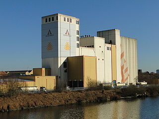
The Mega Cavern is a former limestone mine in Louisville, Kentucky. The cave stretches under parts of the Watterson Expressway and the Louisville Zoo. Due to its support structures, it is classified as a building and is the largest building in Kentucky. The cavern is used for business, storage, recycling, and tourism, with offerings including tram-guided tours, zipline tours, a ropes course, a mountain bike park, and an annual holiday lights display.
A gristmill grinds cereal grain into flour and middlings. The term can refer to either the grinding mechanism or the building that holds it. Grist is grain that has been separated from its chaff in preparation for grinding.

The Blue River is a 57-mile-long (92 km), two-forked stream that runs through Harrison, Crawford and Washington counties in Indiana. The headwaters of the North Fork arise near Salem in Washington County and flow south, and the headwaters of the South Fork arise near New Liberty and flow southwest. The two small forks converge in Fredericksburg. From the confluence, the river flows south until it joins Ohio River in the Harrison-Crawford State Forest, just upstream from Leavenworth.

Indiana Caverns is part of the Binkley Cave system near Corydon, Indiana.

Ruakuri Cave is one of the longer caves in the Waitomo area of New Zealand. It was first discovered by local Māori between 400 and 500 years ago. The name Te Ruakuri, or "The Den of Dogs" was given to the surrounding area when wild dogs were discovered living in the entrance of the cave.
Diamond Caverns in Park City, Kentucky was discovered on July 14, 1859. Tours are available year around; closed Thanksgiving, Christmas Eve, and Christmas. Tours last one hour and is a half mile round trip.
 The village.
 The village.
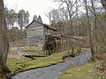 View of the gristmill from the entrance of the park.
 View of the gristmill from upstream.
 View of the gristmill from the front.
 Marker at Boone's original burial site.
 Closeup view of Boone's original burial spot.
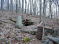 Distant view of location of Boone's original burial cave.


