The African penguin, also known as Cape penguin or South African penguin, is a species of penguin confined to southern African waters. Like all extant penguins, it is flightless, with a streamlined body and wings stiffened and flattened into flippers for a marine habitat. Adults weigh an average of 2.2–3.5 kg (4.9–7.7 lb) and are 60–70 cm (24–28 in) tall. The species has distinctive pink patches of skin above the eyes and a black facial mask. The body's upper parts are black and sharply delineated from the white underparts, which are spotted and marked with a black band.
Amoco Cadiz was a VLCC owned by Amoco Transport Corp and transporting crude oil for Shell Oil. Operating under the Liberian flag of convenience, she ran aground on 16 March 1978 on Portsall Rocks, 2 km (1.2 mi) from the coast of Brittany, France. Ultimately she split in three and sank, resulting in the largest oil spill of its kind in history to that date.
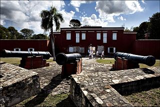
Frederiksted is both the town and one of the two administrative districts of St. Croix, U.S. Virgin Islands. It is a grid-planned city, designed by surveyor Jens Beckfor, originally to 14x14 blocks but built 7x7 to enhance the island commerce in the 1700s. Frederiksted has fewer than 1,000 people in the town proper, but nearly 10,000 in the greater western side of the island. Christiansted is about 30 years older but commerce was limited by its natural, shallow protective reef. Frederiksted was built in the leeward side of the island for calm seas and a naturally deep port. It is home to Fort Frederik, constructed to protect the town from pirate raids and attacks from rival imperialist nations and named after Frederick V of Denmark, who purchased the Danish West Indies in 1754.

MVSelendang Ayu, IMO number: 9145528, was a Malaysian-registered Panamax bulk cargo ship chartered by the IMC Group. It ran aground off Unalaska Island in western Alaska's Aleutian Islands on 8 December 2004 after its engine failed. Six crew members died when a rescue helicopter was engulfed by a breaking wave; the ship broke in two, resulting in a large oil spill.
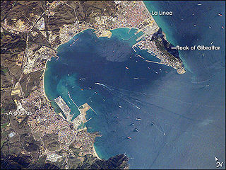
The Bay of Gibraltar, is a bay at the southern end of the Iberian Peninsula. It is around 10 km (6.2 mi) long by 8 km (5.0 mi) wide, covering an area of some 75 km2 (29 sq mi), with a depth of up to 400 m (1,300 ft) in the centre of the bay. It opens to the south into the Strait of Gibraltar and the Mediterranean Sea.

Gqeberha, previously named Port Elizabeth, and colloquially referred to as P.E., is a major seaport and the most populous city in the Eastern Cape province of South Africa. It is the seat of the Nelson Mandela Bay Metropolitan Municipality, South Africa's second-smallest metropolitan municipality by area. It is the sixth-most populous city in South Africa and is the cultural, economic and financial hub of the Eastern Cape.
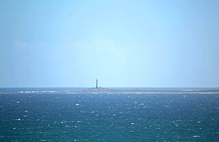
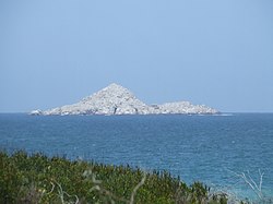
Dassen Island is an uninhabited South African island in the Atlantic Ocean. It is situated about 10 km (6 mi) west of Yzerfontein and 55 km (34 mi) north of Cape Town. The flat and low-lying island measures about 3.1 km (1.9 mi) long northwest-southeast and 1 km (0.6 mi) wide, with an area of 2.73 km2 (1.05 sq mi). It is a proclaimed nature reserve.

Algoa Bay is a maritime bay in the Eastern Cape, South Africa. It is located in the east coast, 683 kilometres (424 mi) east of the Cape of Good Hope.

MV Argo Merchant was a Liberian-flagged oil tanker built by Howaldtswerke in Hamburg, Germany, in 1953, most noted for running aground and subsequently sinking southeast of Nantucket Island, Massachusetts, causing one of the largest marine oil spills in history. Throughout the vessel's troubled past, she was involved in more than a dozen major shipping incidents including two other groundings; once in Indonesia while named Permina Samudra III, and again in Sicily while named Vari; and a collision in Japan.

The Port of Ngqura is a deepwater port on the east coast of South Africa, 20 km northeast of Gqeberha. It was authorised by an act of parliament in 2002, construction started in September 2002 and the port became operational in October 2009 when the MSC Catania docked at the port.
MV Iron Baron was a 37,557 dwt bulk carrier built in 1985. It was chartered by BHP Shipping in 1990.

The 2010 Great Barrier Reef oil spill occurred on 3 April 2010, when the Chinese bulk coal carrier, MV Shen Neng 1 ran aground east of Rockhampton in Central Queensland, Australia. The vessel is owned by Shenzhen Energy Transport Co. Ltd.
The Venpet–Venoil collision was a maritime accident involving sister supertankers; the Liberian-registered Venoil and Venpet, in dense fog off the coast of South Africa on 16 December 1977. The tankers were travelling in opposite directions; the Venoil fully laden with over 250,000 tonnes of crude oil bound for Halifax, Canada, and the Venpet, travelling in ballast, headed for Kharg Island, Iran. The Venoil ploughed into the Venpet, eventually leading to the spilling of approximately 26,600–30,500 tonnes of crude oil. The tankers were sister ships owned and operated by Bethlehem Steel Corporation. Both ships were manned by Taiwanese crews.

Florence Mkhize is an environmental protection vessel operated by the South African Ministry of the Environment. She was launched in June 2006. At 14 metres (46 ft), and capable of 65 knots, she is smaller and faster than four earlier environmental protection vessels. The three vessels in the Lillian Ngoyi class are 47 metres (154 ft) long and capable of 25 knots.
The SS Wafra oil spill occurred on 27 February 1971, when SS Wafra, an oil tanker, ran aground while under tow near Cape Agulhas, South Africa. Approximately 200,000 barrels of crude oil were leaked into the ocean. The larger part of the ship was refloated, towed out to sea, and then sunk by the South African Air Force to prevent further oil contamination of the coastline.
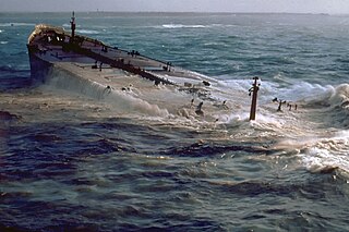
The MV Treasure oil spill occurred on 23 June 2000, when the ship sank six miles off the coast of South Africa while transporting iron ore from China to Brazil. The ship was carrying an estimated 1,300 tons of fuel oil, some of which spilled into the ocean, threatening the African penguin populations living on nearby islands. Cleanup efforts began promptly after the incident with particular attention being paid to salvaging the penguin communities.
The MT Castillo de Bellver oil spill began on 6 August 1983, when the Spanish tanker caught on fire off Saldanha Bay, approximately 70 miles northwest of Cape Town, South Africa. It was carrying 250,000 tonnes of light crude oil, and was traveling through an environmentally sensitive area known for its seabird rookeries and important commercial fishing grounds. The burning vessel was abandoned and broke apart after drifting offshore. Three crew were lost. The stern capsized and sunk and the bow was sunk using explosives. A total of 145,000-170,000 tonnes of oil entered the sea. Onshore impacts were considered negligible as the slick traveled seaward. The only visible impact was the oiling of 1,500 gannets that were on a nearby island.
The Sanchioil tanker collision occurred on 6 January 2018 when the Panamanian-flagged, Iranian-owned tanker Sanchi, with a full natural-gas condensate cargo of 136,000 tonnes, sailing from Iran to South Korea, collided with the Hong Kong-flagged cargo ship CF Crystal 160 nautical miles (300 km) off Shanghai, China. Sanchi caught fire shortly after the collision; after burning and drifting for over a week, it sank on 14 January.
The Addo Elephant National Park Marine Protected Area is a marine conservation area in Algoa Bay, adjacent to the Nelson Mandela Bay Metropolitan Municipality, near Gqeberha, previously Port Elizabeth.
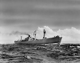
SS Anne Hutchinson was a Liberty ship built by the Oregon Shipbuilding Company of Portland, Oregon, and launched on 31 May 1942 The ship was named after the Anne Hutchinson, a 1600 Massachusetts Bay Colony Puritan.