St. Paul Downtown Airport

Last updated
St. Paul Downtown Airport

Holman Field
20080312-StPaulDowntownAirport.jpg
Aerial photo of St. Paul Downtown Airport, with downtown St. Paul to the upper right, Mississippi River and MSP to the top left
Summary
Airport typePublic
Owner Metropolitan Airports Commission
Serves St. Paul, Minnesota
Location St. Paul, Minnesota, USA
Elevation  AMSL 705 ft / 215 m
Coordinates 44°56′04″N093°03′36″W / 44.93444°N 93.06000°W / 44.93444; -93.06000
Map
USA Minnesota relief location map.svg
Airplane silhouette.svg
STP
Location of airport in Minnesota / United States
Usa edcp relief location map.png
Airplane silhouette.svg
STP
STP (the United States)
Runways
Direction LengthSurface
ftm
14/326,4911,978 Asphalt
13/314,0041,220Asphalt
9/273,6421,110Asphalt
Statistics
Aircraft operations (2014)66,475
Based aircraft (2017)68

St. Paul Downtown Airport( IATA : STP, ICAO : KSTP, FAA LID : STP), also known as Holman Field, is an airport just across the Mississippi River from downtown Saint Paul, Minnesota. It is one of several reliever airports in the Twin Cities operated by the Metropolitan Airports Commission. The airport has three runways and serves aircraft operated by corporations in the local area, a flight training school and the Minnesota Army National Guard aviation unit, as well as transient general aviation aircraft.

Contents

The airport is home to an installation of the Minnesota Army National Guard. Two properties at the airport are listed on the National Register of Historic Places: the 1939 Holman Field Administration Building and the 1942 Riverside Hangar. [2]

History

Holman Field was named for Charles W. "Speed" Holman (1898–1931), who was a stunt pilot, barnstormer, wing walker, parachutist, airmail pilot, aviation record holder and airline pilot. Born in Bloomington, he was the first pilot hired by Northwest Airways in 1926. In 1928, Holman set a world record of 1,433 consecutive loops in an airplane in five hours over the St. Paul Airport. He died in an accident during an air show in Omaha in 1931 at the age of 32. [3]

During World War II, Northwest Airlines employed up to 5,000 people at the site, modifying new B-24 Liberator bombers, some of which received the highly classified H2X radar, which proved to be an invaluable tool in the European theater. [4]

The terminal was used as a backdrop for scenes in the 1972 film Slaughterhouse-Five .[ citation needed ]

During the 1970s and early 1980s, commuter airline Lake State Airways offered scheduled airline service between the St. Paul Downtown Airport and Minneapolis–St. Paul International Airport in Minnesota. It cost $5USD for a one-way ticket between the two airports, and $10 round-trip. [5] Capitol Air flew MDW-STP with a Swearingen Metroliner for roughly a year starting in December 1993.

Facilities and aircraft

St. Paul Downtown Holman Field covers an area of 540 acres (220  ha ) which contains three asphalt paved runways: 14/32 measuring 6,491 x 150 ft (1,978 x 46 m), 13/31 measuring 4,004 x 150 ft (1,220 x 46 m) and 9/27 measuring 3,642 x 100 ft (1,110 x 30 m). [1]

For the 12-month period ending December 31, 2014, the airport had 66,475 aircraft operations, an average of 182 per day: 74% general aviation, 15% military and 11% air taxi. In January 2017, there were 68 aircraft based at this airport: 20 single-engine, 12 multi-engine, 18 jet, 7 helicopter and 11 military. [1]

Annual aircraft operations

Based on annual reports and data released by the Metropolitan Airports Commission, aircraft operations declined 65.3% in the decade 2011-2020.

YearAircraft operationsPercent Change
201187,229 [6] N/A
201279,238 [7] Decrease2.svg9.16%
201369,277 [8] Decrease2.svg12.57%
201464,539 [9] Decrease2.svg6.83%
201556,676 [10] Decrease2.svg12.18%
201654,548 [11] Decrease2.svg3.75%
201740,489 [12] Decrease2.svg25.77%
201840,116 [13] Decrease2.svg0.92%
201940,394 [14] Increase2.svg0.69%
202030,188 [15] Decrease2.svg25.26%
202139,196 [16] Increase2.svg29.83%
202241,592 [17] Increase2.svg6.11%

Charter Airlines

AirlineServices
NetJets Charter
Executive Jet ManagementCharter
Best Jets InternationalCharter/FBO
Delta Private Jets Charter

Flood wall considerations

Recently local debate has ensued over plans to build a flood wall around the airport. In 1993, 1997, and 2001, the airport was flooded due to its proximity to the Mississippi River. Supporters do not want to deal with the future inconvenience of having to deal with the flood again, while critics say that the proposed wall would ruin views and make the airport "ugly". [18] A dike to protect the airport from the nearby river was considered since the National Guard stated that they may leave if the dike is not constructed in a timely manner.[ citation needed ]

In 2009, a removable flood wall was installed that is only erected when flooding is imminent, leaving the views of the river intact for the rest of the year. Steel plates are embedded in the concrete on the river side of the runways. The flood wall is composed of steel posts that anchor to the embedded plates and aluminum planks that are stacked between the posts to form a flood barrier. These are then removed and stored when the flood event has passed.

See also

Related Research Articles

<span class="mw-page-title-main">Meigs Field</span> Chicago airport (1948–2003)

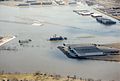
Merrill C. Meigs Field Airport was a single-runway airport in Chicago that was in operation from 1948 to 2003, when it was bulldozed overnight by then-mayor Richard M. Daley. The airport was located on Northerly Island, an artificial peninsula on Lake Michigan adjacent to downtown Chicago, the second-largest business district in the Western Hemisphere. By 1955, Meigs Field had become the busiest single-strip airport in the United States. The airport was a familiar sight on the downtown lakefront. The latest air traffic tower was built in 1952, and the terminal was dedicated in 1961. The airfield was named for Merrill C. Meigs.

<span class="mw-page-title-main">Oxnard Airport</span> General aviation airport in Oxnard, California

Oxnard Airport is a county-owned, public airport a mile west of downtown Oxnard, in Ventura County, California. The airport has not had scheduled passenger service since June 8, 2010, when United Express ended flights to Los Angeles International Airport. America West Express also served the airport with nonstop flights to Phoenix in the early-2000s via a code sharing agreement with America West Airlines.

<span class="mw-page-title-main">Orlando Sanford International Airport</span> Public airport in Sanford, Florida, United States

Orlando Sanford International Airport is in Sanford, Florida, United States, near Orlando. It was built as Naval Air Station Sanford, a Master Jet Base for carrier-based attack and reconnaissance aircraft, and was used by the U.S. Navy until 1969. The airport is owned and operated by the Sanford Airport Authority. It serves as an operating base for Allegiant Air.

Tallahassee International Airport Airport in Florida, U.S.

Tallahassee International Airport is a city-owned airport five miles southwest of downtown Tallahassee, in Leon County, Florida, United States. It serves the state capital of Florida, and its surrounding areas; it is one of the major airports in north Florida, the others being Pensacola, Northwest Florida Beaches, and Jacksonville. Despite its name, it does not service any international destinations.

<span class="mw-page-title-main">Boise Airport</span> Civil/military airport in Boise, Idaho, U.S.

Boise Airport is a joint civil-military airport in the western United States in Idaho, three miles (5 km) south of downtown Boise in Ada County. The airport is operated by the city of Boise Department of Aviation, overseen by an airport commission. The busiest airport in the state, it serves more passengers than all other Idaho airports combined and roughly ten times as many passengers as the next busiest airport at Idaho Falls.

<span class="mw-page-title-main">Rochester International Airport</span> Airport in Rochester, Minnesota

Rochester International Airport is an international airport located seven miles (11 km) south of downtown Rochester in Olmsted County, Minnesota. It is the second-busiest airport in Minnesota. Its name used to be "Rochester Municipal Airport", before adding customs and immigration facilities specifically for Mayo Clinic purposes in 1995.

Charles B. Wheeler Downtown Airport is a city-owned, public-use airport serving Kansas City, Missouri, United States. Located in Clay County, this facility is included in the National Plan of Integrated Airport Systems, which categorized it as a general aviation reliever airport.

<span class="mw-page-title-main">Cheyenne Regional Airport</span> Airport in Cheyenne, Wyoming, USA

Cheyenne Regional Airport is a civil-military airport a mile north of downtown Cheyenne, in Laramie County, Wyoming. It is owned by the Cheyenne Regional Airport Board.

<span class="mw-page-title-main">Fort Worth Meacham International Airport</span> General aviation airport in Fort Worth, Texas

Fort Worth Meacham International Airport is a general aviation airport located near the intersection of Interstate 820 and Business U.S. Highway 287 in Fort Worth, Texas, United States. It is named after former Fort Worth Mayor Henry C. Meacham. The airport covers 745 acres.

<span class="mw-page-title-main">Glacier Park International Airport</span> Airport in Montana, United States

Glacier Park International Airport is in Flathead County, Montana, United States, six miles northeast of Kalispell. The airport is owned and operated by the Flathead Municipal Airport Authority, a public agency created by the county in 1974. The airport is near Glacier National Park.

<span class="mw-page-title-main">Montgomery Regional Airport</span> Airport

Montgomery Regional Airport is a civil-military airport seven miles southwest of Montgomery, the capital of Alabama. Owned by the Montgomery Airport Authority, it is used for general aviation and military aviation, and sees two airlines.

<span class="mw-page-title-main">Central Wisconsin Airport</span> Airport located in Mosinee, Wisconsin

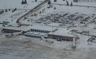
Central Wisconsin Airport, referred to as "C-Way", is a public airport located 3 nautical miles southeast of the central business district of Mosinee, in Marathon County, Wisconsin, United States. It is owned by Marathon County and Portage County. It is included in the Federal Aviation Administration (FAA) National Plan of Integrated Airport Systems for 2023–2027, in which it is categorized as a non-hub primary commercial service facility. It is the fifth busiest of eight commercial airports in Wisconsin in terms of passengers served.

<span class="mw-page-title-main">Page Field</span> Airport in Florida, U.S.

Page Field is a public airport located in Fort Myers, in Lee County, Florida, United States. It is owned by the Lee County Port Authority; the National Plan of Integrated Airport Systems for 2011–2015 categorized it as a reliever airport.

<span class="mw-page-title-main">Abraham Lincoln Capital Airport</span> Airport serving Springfield, Illinois, USA

Abraham Lincoln Capital Airport is a civil-military airport in Sangamon County, Illinois, United States, three miles (6 km) northwest of downtown Springfield. It is owned by the Springfield Airport Authority (SAA).

<span class="mw-page-title-main">Fitchburg Municipal Airport</span> Airport in Fitchburg, Massachusetts

Fitchburg Municipal Airport is a public airport located 3 miles (5 km) southeast of the central business district of Fitchburg, a city in Worcester County, Massachusetts, United States. This airport is owned by the City of Fitchburg. The airport also serves as a base for the Fitchburg Pilots Association/EAA chapter 1454. This group uses the airport to host events such as Young Eagles and flights in EAA's Ford Trimotor. The airport underwent a renovation in 2020 that extended runway 14/32 by 500 feet to its current length of 5001 feet. The runway extension was to meet requirements for insurance companies to permit certain small jets to land and take off from the airport. The renovation removed runway 2/20. Occasionally the airport serves as a home for rock festivals such as The Warped Tour and Locobazooka.

Airlake Airport is a public use airport in Dakota County, Minnesota, United States. Owned by the Metropolitan Airports Commission, It is approximately 20 miles (32 km) south of both downtown Minneapolis and downtown St. Paul The airport is located near the Twin Cities suburbs of Lakeville and Farmington.

<span class="mw-page-title-main">Crystal Airport (Minnesota)</span> Airport in Crystal, Minnesota

Crystal Airport is a public airport named after the city of Crystal in Hennepin County, Minnesota, United States. Most of the airport is in the city of Crystal. Portions north of taxiway C are in Brooklyn Park, and the north east corner of the airport is in Brooklyn Center. It is eight miles (13 km) northwest of the central business district of Minneapolis and is owned by the Metropolitan Airports Commission. The airport covers an area of approximately 430 acres.

<span class="mw-page-title-main">St. Louis Downtown Airport</span> Airport in St. Clair County, Illinois

St. Louis Downtown Airport is a public-use airport located in Greater St. Louis, one mile (2 km) east of the central business district of Cahokia Heights, in St. Clair County, Illinois, United States. It is owned by the Bi-State Development Agency. The airport is located less than 3 miles from the Gateway Arch riverfront in St. Louis and is used by many business aircraft visiting the St. Louis region. Airport services include one full-service 24-hour fixed-base operator, an instrument landing system, an FAA air traffic control tower, and its own dedicated Index B aircraft rescue and firefighting (ARFF) service. It is utilized mainly by Saint Louis University's Parks College of Engineering, Aviation and Technology for training purposes, as well as the St. Louis Cardinals for charter flights to away games.

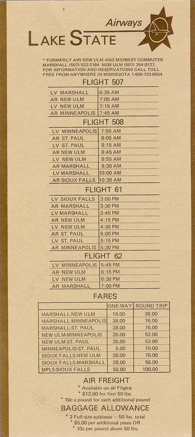
Southwest Minnesota Regional Airport or Marshall/Ryan Field is a general aviation airport located 1 mile west of the central business district (CBD) of Marshall, Minnesota, United States. It is primarily a general aviation facility, though passenger air service did once exist on Midwest Aviation, also known as Lake State Airways. The namesake for Ryan Field is Matthew Ryan, commissioner of small airport around Minneapolis.

Mankato Regional Airport is a public airport located five miles (8 km) northeast of the central business district of Mankato, a city in Blue Earth County, Minnesota, United States. This airport is publicly owned by the city of Mankato. The airport is home to North Star Aviation (FBO) and Minnesota State University's flight training program. Base to Mn composite Squadron Mn 048 Civil Air Patrol (CAP/USAF-AUX)

References

PD-icon.svg This article incorporates public domain material from the Air Force Historical Research Agency

  1. 1 2 3 FAA Airport Form 5010 for STP PDF , effective Jan 5, 2017.
  2. "Minnesota National Register Properties Database". Minnesota Historical Society. 2009. Retrieved 2018-01-01.
  3. (nd) Ask A Historian Archived 2012-06-03 at the Wayback Machine . Ramsey County Historical Society. Retrieved 5/31/07.
  4. Kenney, Dave (2004). Minnesota Goes to War - The Home front During World War II. Minnesota Historical Society Press. ISBN   978-0-87351-506-1 . Retrieved 2008-01-30.
  5. TimeTableImages.com
  6. "Archived copy" (PDF). metroairports.org. Archived from the original (PDF) on 15 February 2021. Retrieved 22 May 2022.{{cite web}}: CS1 maint: archived copy as title (link)
  7. https://metroairports.org/resources/annual-report-legislature-2012 [ dead link ]
  8. https://web.archive.org/web/20210215033646/https://metroairports.org/sites/default/files/files/2014-annual-report-to-the-legislature.pdf
  9. https://web.archive.org/web/*/https://metroairports.org/resources/2014-annual-report-legislature
  10. https://web.archive.org/web/*/https://metroairports.org/resources/2015msplegislativereport
  11. https://metroairports.org/resources/annual-report-2017 [ dead link ]
  12. https://web.archive.org/web/*/https://metroairports.org/resources/annual-report-2017
  13. https://web.archive.org/web/*/https://metroairports.org/resources/annual-report-2018
  14. https://web.archive.org/web/*/https://metroairports.org/resources/2019-annual-report
  15. "MAC Reliever Airports thrived in 2020 despite pandemic".
  16. "St. Paul Downtown Airport (STP) 2021 Annual Report".
  17. "Traffic at St. Paul's Holman Field airport increased nearly 5 percent in 2022". 8 February 2023.
  18. Helms, Marisa (2006-04-05). "Airport flood project stirs the waters in St. Paul". Minnesota Public Radio. Retrieved 2008-01-30.