
Erewhon: or, Over the Range is a novel by English writer Samuel Butler, first published anonymously in 1872, set in a fictional country discovered and explored by the protagonist. The book is a satire on Victorian society.
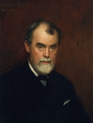
Samuel Butler was an English novelist and critic, best known for the satirical utopian novel Erewhon (1872) and the semi-autobiographical novel The Way of All Flesh. Both novels have remained in print since their initial publication. In other studies he examined Christian orthodoxy, evolutionary thought, and Italian art, and made prose translations of the Iliad and Odyssey that are still consulted.
This is a timeline of environmental history of New Zealand. It includes notable events affecting the natural environment of New Zealand as a result of human activity.

Lake Ōhau is a lake in the Mackenzie Basin in the South Island of New Zealand. The Hopkins and Dobson rivers fed into the northern end of Lake Ōhau. These rivers have their headwaters in the Southern Alps / Kā Tiritiri o te Moana. The lake's outflow is the Ōhau River, which travels from the southeast corner of Lake Ōhau and feeds into the Waitaki River hydroelectric project. The Barrier range dominate the western side of Lake Ōhau, while the Ben Ohau range dominates the eastern side of Lake Ōhau. At the northern end of the lake, in between the Hopkins and Dobson rivers, lies the Naumann Range of mountains.

The Rangitata River is one of the braided rivers that helped form the Canterbury Plains in southern New Zealand. It flows southeast for 120 kilometres (75 mi) from the Southern Alps, entering the Pacific Ocean 30 kilometres (19 mi) northeast of Timaru. The river has a catchment area of 1,773 square kilometres (685 sq mi), and a mean annual flow of 95 cubic metres per second (3,400 cu ft/s) at Klondyke.

William Herbert Guthrie-Smith FRSNZ was a New Zealand farmer, author and conservationist.

A sheep station is a large property in Australia or New Zealand, whose main activity is the raising of sheep for their wool and/or meat. In Australia, sheep stations are usually in the south-east or south-west of the country. In New Zealand the Merinos are usually in the high country of the South Island. These properties may be thousands of square kilometres in size and run low stocking rates to be able to sustainably provide enough feed and water for the stock.

Lake Tūtira is a body of water in north-eastern Hawke's Bay in New Zealand.

Wilding conifers, also known as wilding pines, are invasive trees in the high country of New Zealand. Millions of dollars are spent on controlling their spread.

In New Zealand, agriculture is the largest sector of the tradable economy. The country exported NZ$46.4 billion worth of agricultural products in the 12 months to June 2019, 79.6% of the country's total exported goods. The agriculture, forestry and fisheries sector directly contributed $12.653 billion of the national GDP in the 12 months to September 2020, and employed 143,000 people, 5.9% of New Zealand's workforce, as of the 2018 census.

The Rees River is a headwater tributary of the Clutha River / Mata-Au that drains eastward of the main divide of the Southern Alps / Kā Tiritiri o te Moana in New Zealand. The river runs 41 km, drains an area of 406 km2, and discharges into the head of Lake Wakatipu at Glenorchy. Bound by the Richardson (Whakaari) Mountains to the east and the Forbes Mountains to the west, its snow-covered headwaters rise above 2000 m.

John Studholme (1829–1903) was a 19th-century British pioneer of New Zealand, farmer and politician in the Canterbury region of New Zealand.
Mesopotamia Station is a high-country station in New Zealand's South Island. Known mainly for one of its first owners, the novelist Samuel Butler, it is probably the country's best known station. Despite popular belief, Butler was not the station's first owner.

Sheep farming is a significant industry in New Zealand. According to 2007 figures reported by the Food and Agriculture Organization (FAO) of the United Nations, there are 39 million sheep in the country. The country has the highest density of sheep per unit area in the world. For 130 years, sheep farming was the country's most important agricultural industry, but it was overtaken by dairy farming in 1987. Sheep numbers peaked in New Zealand in 1982 to 70 million and then dropped to about 27.6 million. There are 16,000 sheep and beef farms in the country which has made the country the world's largest exporter of lambs, with 24 million finished lambs recorded every year.

Barrhill is a lightly populated locality in the Canterbury region of New Zealand's South Island. It is situated on the Canterbury Plains, on the right bank of the Rakaia River, about 17 kilometres (11 mi) inland from Rakaia. It was founded by Cathcart Wason in the mid-1870s and named by him after his old home Barrhill in South Ayrshire, Scotland. Wason set it up as a model village for the workers of his large sheep farm. The population of the village peaked in the mid-1880s before the general recession initiated a downturn for the village. Wason had expected for the Methven Branch railway to run past Barrhill, but the line was built in 1880 on an alignment many miles away, which caused Barrhill population to decrease.
Airini Elizabeth Woodhouse was a New Zealand community leader, historian, and author.

The Butler Range is a range located in the Ashburton District of Canterbury on the South Island of New Zealand. To the south of the range is the Rakaia River. The area was first farmed by Samuel Butler, who called his holding Mesopotamia Station. The highest peak of Butler Range is Lauper Peak at 2,485 metres (8,153 ft), named after the Swiss-born explorer Jakob Lauper. Mount Butler is located further south in the Butler Range and is also named after Samuel Butler.
Mesopotamia is an area of land at the head of the Rangitata River, east of the Southern Alps and inland from Peel Forest. The area is home to the well known Mesopotamia Station which was established by influential novelist Samuel Butler in 1860 after arriving from England. The name Mesopotamia means "between two rivers."

Ahuriri Conservation Park is a protected area of 49,000 hectares including tussock grasslands, forest, and river habitat, located in Canterbury, South Island, New Zealand, and centred around the headwaters of the Ahuriri River.

The Rangitata Diversion Race or RDR is a combined irrigation and power generation scheme that diverts water from the Rangitata River to irrigate over 100,000 hectares of farmland in Mid-Canterbury, New Zealand. The RDR project was the first major river diversion in New Zealand, and the largest irrigation scheme in the country. It was originally constructed by the Public Works Department between 1937 and 1944. The main canal is 67 km long, 10 m wide and 3 m deep.
