Statutory city (Austria)

Last updated

In Austrian politics, a statutory city (German: Stadt mit eigenem Statut or Statutarstadt), also known in Burgenland as free city (German: Freistadt), is a city that is vested, in addition to its purview as a municipality, with the powers and duties of a district administrative authority. The city administration thus functions as both a municipal government and a branch of the executive arm of the national government. A resident of a statutory city would, for example, contact a city office and interact with city employees to apply for a driver's license or a passport.

As of 2022, there are 15 statutory cities. Statutory cities are mostly major regional population centers with residents numbering in the tens of thousands. The median statutory city has a population of about sixty thousand. [1]

A statutory city is a city vested with both municipal and district administrative responsibility. A district that is a statutory city does not have a dedicated district administrative authority. Instead, town hall personnel also serves as district personnel; the mayor also discharges the powers and duties of a head of district commission. City management thus functions both as a regional government and a branch of the national government at the same time. [2]

The constitution stipulates that a community with at least 20,000 residents can demand to be elevated to statutory city status by its respective province, unless the province can demonstrate this would jeopardize regional interests, or unless the national government objects. The last community to have invoked this right is Wels, a statutory city since 1964. As of 2014, ten other communities are eligible but not interested.

Vienna

The statutory city of Vienna, a community with well over 1.9 million residents, is divided into 23 municipal districts (Gemeindebezirke). Despite the similar name and the comparable role they fill, municipal districts have a different legal basis than the kind of district that Vienna as a whole is. The statutory cities of Graz and Klagenfurt also have subdivisions referred to as "municipal districts", but these are merely neighborhood-size divisions of the city administration.

History

From the Middle Ages until the mid-eighteenth century, the Austrian Empire was an absolute monarchy with no written constitution and no modern concept of the rule of law. Regional administration had no overarching legal framework; customs were different from province to province. A first step towards a systematic footing was taking by Empress Maria Theresa, who in 1753 partitioned the country into districts (Kreise) ruled by district offices (Kreisämter) staffed by professional administrators and operating under empire-wide consistent rules. The scheme was unpopular at first and met with resistance. Most notably, it was never fully implemented in the Kingdom of Hungary. [3]

Following the first wave of the revolutions of 1848, Emperor Ferdinand I enacted Austria's first formal constitution. The constitution abolished the estates and called for a separation of executive and judicial authority, crippling most existing regional institutions and leaving district offices as the backbone of the empire's administration.

An 1849 Imperial Resolution consolidated and reaffirmed and revised the system. [4] The law was implemented in 1850, many districts now already in their present-day borders. Small to medium towns and villages were arranged into districts of ten to thirty municipalities each. Larger cities were made districts of their own; these cities would from now on be referred to as statutory cities. The first statutory cities in regions that are still part of Austria today were Vienna, Graz, Innsbruck, and Klagenfurt.

Between 1848 and 1867 the empire, its constitution, and its civil administration framework underwent a series of upheavals culminating in the Austro-Hungarian Compromise of 1867. Ferdinand was forced to abdicate; his successor Franz Joseph I scrapped the district system in 1851 but was forced to assent to its restoration in 1868. [5]

By 1869, Linz, Wiener Neustadt, Steyr, and Salzburg had gained statutory city status.

The Republic of Austria established after the 1918 collapse of the monarchy retained the district system. [6]

The 1867 Compromise had meant the partition of the empire; Cisleithania and the Kingdom of Hungary were now two separate countries with separate types of administrative subdivisions. There would be no more attempts to impose the district system on Hungary and consequently no more attempts to create Hungarian statutory cities. Hungary retained an older system, in which major municipalities could be elevated to royal free city status. When Hungary ceded Burgenland to Austria in 1921, the region included two of these royal free cities, Eisenstadt and Rust. The distinction went back to 1648 in the case of Eisenstadt and back to 1681 in the case of Rust. Honoring their archaic privileges even though they had lost their significance as population centers, Austria transformed the two towns into statutory cities.

Between 1922 and 1964, the status was given to three additional communes.

List of current statutory cities

The code column identifies each city's district code (Bezirkskennzahl), Est. means the year of becoming the status of statutory city.

CodeNameEst.License platePopulation 2022
101 Eisenstadt 1921E15,240
102 Rust 1921E [note 1] 1,984
201 Klagenfurt am Wörthersee 1850K102,618
202 Villach 1932VI64,071
301 Krems an der Donau 1938KS24,921
302 Sankt Pölten 1922P56,360
303 Waidhofen an der Ybbs 1868WY11,092
304 Wiener Neustadt 1866WN47,106
401 Linz 1866L207,247
402 Steyr 1867SR37,879
403 Wels 1964WE63,181
501 Salzburg 1869S155,416
601 Graz 1850G292,630
701 Innsbruck 1850I130,585
901 Wien 1850W1,931,593

Notes

  1. Rust shares Eisenstadt's E code.

Related Research Articles

<span class="mw-page-title-main">Burgenland</span> Austrian state

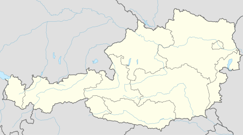
Burgenland is the easternmost and least populous state of Austria. It consists of two statutory cities and seven rural districts, with a total of 171 municipalities. It is 166 km (103 mi) long from north to south but much narrower from west to east. The region is part of the Centrope Project. The name of Burgenland was invented/coined in 1922, after its territories became part of Austria.

<span class="mw-page-title-main">Eisenstadt</span> City in Burgenland, Austria

Eisenstadt is the capital city of the Austrian state of Burgenland. With a population of 15,074, it is the smallest state capital and the 38th-largest city in Austria overall. It lies at the foot of the Leitha Mountains hill range.

<span class="mw-page-title-main">Rust, Burgenland</span> City in Burgenland, Austria

Rust is a city in the Austrian state of Burgenland, located on the western shore of Lake Neusiedl near the border with Hungary. With only about 1,900 inhabitants, it is the country's smallest statutory city, as it was endowed with the rights of a royal free city by the Hungarian crown in 1681. As a Statutarstadt, it also forms an administrative district (Bezirk) in its own right. The city is famous for its wines, especially for Beerenauslese, ice wine and - especially - Ruster Ausbruch.

<span class="mw-page-title-main">Kingdom of Bohemia</span> Monarchy in Central Europe (1198–1918), predecessor of modern Czechia

The Kingdom of Bohemia, sometimes referenced in English literature as the Czech Kingdom, was a medieval and early modern monarchy in Central Europe. It was the predecessor of the modern Czech Republic.

<span class="mw-page-title-main">Districts of Austria</span> Administrative subdivision of Austria

A district is a second-level division of the executive arm of the Austrian government. District offices are the primary point of contact between residents and the state for most acts of government that exceed municipal purview: marriage licenses, driver licenses, passports, assembly permits, hunting permits, or dealings with public health officers for example all involve interaction with the district administrative authority.

<span class="mw-page-title-main">NUTS statistical regions of Austria</span>

The Nomenclature of Territorial Units for Statistics (NUTS) is a geocode standard for referencing the subdivisions of Austria for statistical purposes. The standard is developed and regulated by the European Union. The NUTS standard is instrumental in delivering the European Union's Structural Funds. The NUTS code for Austria is AT and a hierarchy of three levels is established by Eurostat. Below these is a further levels of geographic organisation - the local administrative unit (LAU). In Austria, the LAU 2 is municipalities.

<span class="mw-page-title-main">Judiciary of Austria</span> Overview of court system in Austria

The judiciary of Austria is the system of courts, prosecution and correction of the Republic of Austria as well as the branch of government responsible for upholding the rule of law and administering justice. The judiciary is independent of the other two branches of government and is committed to guaranteeing fair trials and equality before the law. It has broad and effective powers of judicial review.

The Federal Office of Metrology and Surveying of Austria is the body responsible for official surveying, geo-information and weights and measures (metrology) in Austria. It belongs to the Bundesministerium für Wirtschaftsstandort und Digitalisierung. Its headquarters is in Vienna and it has 67 branches spread across all the Austrian federal states.

<span class="mw-page-title-main">Neusatz District</span> Defunct district of the Voivodeship of Serbia and Banat of Temeschwar

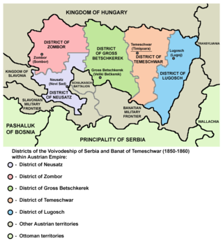
Neusatz District was one of five administrative districts of the Voivodeship of Serbia and Banat of Temeschwar from 1850 to 1860. Its administrative center was Neusatz.

<span class="mw-page-title-main">Zombor District</span> Administrative district of Voivodeship of Serbia and Banat of Temeschwar

Zombor District was one of five administrative districts of the Voivodeship of Serbia and Temes Banat from 1850 to 1860. Its administrative center was Zombor.

<span class="mw-page-title-main">Großbetschkerek District</span> Administrative district of Voivodeship of Serbia and Banat of Temeschwar

Großbetschkerek District was one of five administrative districts of the Voivodeship of Serbia and Banat of Temeschwar from 1850 to 1860. Its administrative center was Großbetschkerek.

<span class="mw-page-title-main">Margraviate of Moravia</span> Part of the Bohemian Crown from 1182 to 1918

The Margraviate of Moravia was one of the Lands of the Bohemian Crown within the Holy Roman Empire and then Austria-Hungary, existing from 1182 to 1918. It was officially administered by a margrave in cooperation with a provincial diet. It was variously a de facto independent state, and also subject to the Duchy, later the Kingdom of Bohemia. It comprised the historical region called Moravia, which lies within the present-day Czech Republic.

The December Constitution is a set of six acts that served as the constitution of the Cisleithanian half of Austria-Hungary. The acts were proclaimed by Emperor Franz Joseph on 21 December 1867 and functioned as the supreme law of the land until the collapse of the empire in 1918. Five of the Constitution's acts were replaced by the Federal Constitutional Law between 1918 and 1920; the sixth law, a bill of rights, is still in force.

<span class="mw-page-title-main">Municipality (Austria)</span> Local administrative unit in Austria

In the Republic of Austria, the municipality is the administrative division encompassing a single village, town, or city. The municipality has corporate status and local self-government on the basis of parliamentary-style representative democracy: a municipal council elected through a form of party-list system enacts municipal laws, a municipal executive board and a mayor appointed by the council are in charge of municipal administration. Austria is currently partitioned into 2,095 municipalities, ranging in population from about fifty to almost two million. There is no unincorporated territory in Austria.

<i>Kreis</i> (Habsburg monarchy) Administrative division of Austria (1748–1867)

A Kreis or 'Circle' was an administrative division of the Habsburg monarchy and Austrian Empire between 1748 and 1867.

<span class="mw-page-title-main">Temesvár District</span> Administrative district of Voivodeship of Serbia and Banat of Temeschwar

Temesvár District was one of five administrative districts of the Voivodeship of Serbia and Banat of Temeschwar from 1851 to 1860. Its administrative centre was Temesvár, which was also the capital of the crown land. Following the 1854 reform Temesvár itself was directly subject to the crown land, and so separate from the district, while still acting as its capital.

<span class="mw-page-title-main">Lugos District</span> Administrative district of Voivodeship of Serbia and Banat of Temeschwar

Lugos District was one of five administrative districts of the Voivodeship of Serbia and Banat of Temeschwar from 1851 to 1860. Its administrative centre was Lugos.

References

  1. "Politische Bezirke". Statistik Austria. November 20, 2014. Retrieved November 24, 2014.
  2. Federal Constitutional Law article 116; BGBl. 1/1930
  3. Lechleitner, Thomas (1997). "Die Bezirkshauptmannschaft" . Retrieved November 28, 2014.
  4. Kaiserliche Entschließung vom 26. Juni 1849, wodurch die Grundzüge für die Organisation der politischen Verwaltungs-Behörden genehmiget werden; RGBl. 295/1849
  5. Gesetz von 19. Mai 1868, über die Einrichtung der politischen Verwaltungsbehörden; RGBl. 44/1868
  6. Gesetz vom 1. Oktober 1920, womit die Republik Österreich als Bundesstaat eingerichtet wird (Bundes-Verfassungsgesetz; SGBl. 450/1920