Stepney City Farm

Last updated
Stepney City Farm Stepney City Farm sign (7462997756).jpg
Stepney City Farm

Stepney City Farm is a city farm in Stepney, London, England. It is situated on Stepney Way with its entrance on the roundabout leading onto Stepney High Street and Belgrave Street towards Limehouse. The land is owned by Tower Hamlets Council through a trust, "The King George's Fields Trust" [1] chaired by the Mayor of Tower Hamlets. [2]

Contents

The farm was founded in 1979 by Lynne Bennett; at that time it was called Stepping Stones. Local residents, schools, churches and community groups were consulted and wasteland left after a World War II bomb destroyed the Stepney Congregational Church in 1941 was secured for the farm's use. [3] The site has been through several incarnations since the 17th century. [4] Worcester house (locally known as King John's Palace) was an original building from which ruins remain onsite, and the remains of the old Sunday school and the Stepney meeting house can be seen. [5] [6]

Known as the Stepping Stones Farm up until 2009 under the management of Lynne Bennett, [7] the 4.2-acre. [3] [8] From 2009 to 2012 the farm was technically the legal and financial responsibility of Tower Hamlets Council [1] but is now run by a charity, "Stepney City Farm Ltd", [9] with a 10-year lease as from 2012 (registered in June 2010 as Charity Number 1136448). [10] The farm also runs workshops in rural crafts through its resident artisans; blacksmith, woodworker and potter. In 2011, the farm created an 800 square metre community garden and added low-cost growing boxes for community use. [11]

In May 2013 a cafe and shop selling farm-reared meat and eggs as well as vegetables grown on-site was opened. It is open to the public six days a week. There is a Farmers' Market every Saturday. It is the home of The Green Wood Guild, a green wood and traditional woodworking craft workshop run by Barn the Spoon. [12]

In January 2023, Stepney City Farm were one of the two city farms featured in the Lambeth Country Show edition of BBC One's afternoon programme The Farmers' Country Showdown. [13] [14]

Crossrail

In 2010 Crossrail took over approximately a third of the Farm's site as part of the works to build a rail transport link connecting east and west London. [1] This work was scheduled to end in 2018 [15] with the land returned to the farm.[ needs update ] In January 2011 Crossrail opened up an archaeological dig at the construction site on the farm. [16] A ventilation shaft next door to the farm leads down to one of the largest mined caverns in Europe. [17] In mitigation Crossrail worked closely with the farm to allow the existing animals to remain by making major improvements to the farm, especially the drainage of the fields and building a large barn for overwintering the animals and a rural arts building to house the farm's craftspeople. [18] The farm officially opened these buildings on 8 September 2012. [19]

Lloyd and Leila

The farm's bull and cow Lloyd and Leila were featured in Strictly Come Dancing with Nancy Dell'Olio and Anton du Beke in 2011. [20] In 2013 the cows' grazing field became unavailable as a result of Crossrail construction. [21] The cows were offered a permanent home at Hillside Animal Sanctuary, but there was a problem with moving them there as they had not been registered properly at birth by the original charity, as has been a legal requirement by the British Cattle Movement Service for all cattle born in the UK since 1 July 1996. [22] A campaign was started to get permission from the Department for Environment, Food and Rural Affairs (Defra) to grant an exemption to the usual cattle movement restrictions. The exemption was not granted despite the involvement of local Member of Parliament, Jim Fitzpatrick (former Minister for Defra), and the cows were culled in December 2013. [21]

Related Research Articles

<span class="mw-page-title-main">Bethnal Green</span> Human settlement in England

Bethnal Green is an area in the East End of London, England, 3 miles (4.8 km) north-east of Charing Cross. The area emerged from the small settlement which developed around the Green, much of which survives today as Bethnal Green Gardens, beside Cambridge Heath Road. By the 16th century the term applied to a wider rural area, the Hamlet of Bethnal Green, which subsequently became a Parish, then a Metropolitan Borough before merging with neighbouring areas to become the north-western part of the new London Borough of Tower Hamlets.

<span class="mw-page-title-main">Isle of Dogs</span> Area in the East End of London, England

The Isle of Dogs is a large peninsula bounded on three sides by a large meander in the River Thames in East London, England, which includes the Cubitt Town, Millwall and Canary Wharf districts. The area was historically part of the Manor, Hamlet, Parish and, for a time, the wider borough of Poplar. The name had no official status until the 1987 creation of the Isle of Dogs Neighbourhood by Tower Hamlets London Borough Council. It has been known locally as simply "the Island" since the 19th century.

<span class="mw-page-title-main">Stepney</span> Human settlement in England

Stepney is a district in the East End of London in the London Borough of Tower Hamlets. The district is no longer officially defined, and is usually used to refer to a relatively small area. However, for much of its history the place name applied to a much larger manor and parish. Stepney Green is a remnant of a larger area of Common Land formerly known as Mile End Green.

<span class="mw-page-title-main">Whitechapel</span> Human settlement in England

Whitechapel is a district in the London Borough of Tower Hamlets in the East End of London, located 3.4 miles (5.5 km) east of Charing Cross.

<span class="mw-page-title-main">London Borough of Tower Hamlets</span> Borough in London, England

The London Borough of Tower Hamlets is a borough of London, England. Situated on the north bank of the River Thames and immediately east of the City of London, the borough spans much of the traditional East End of London and includes much of the regenerated London Docklands area. The 2019 mid-year population for the borough is estimated at 324,745.

<span class="mw-page-title-main">Crossrail</span> Railway project in London, England

Crossrail was a railway construction project centred around London. It aimed to provide a high-frequency hybrid commuter rail and rapid transit system crossing the capital from suburbs on the west to east, by connecting two major railway lines terminating in London: the Great Western Main Line and the Great Eastern Main Line. The project was approved in 2007, and construction began in 2009 on the central section and connections to existing lines that became part of the route, which has been named the Elizabeth line in honour of Queen Elizabeth II who opened the line on 17 May 2022 during her Platinum Jubilee. The central section of the line between Paddington and Abbey Wood opened on 24 May 2022, with 12 trains per hour running in each direction through the core section in Central London.

<span class="mw-page-title-main">Holstein Friesian</span> Breed of dairy cattle

The Holstein Friesian is an international breed or group of breeds of dairy cattle. It originated in the Dutch provinces of North Holland and Friesland and in Schleswig-Holstein in northern Germany. It is the dominant breed in industrial dairy farming worldwide, and is found in more than 160 countries. It is known by many names, among them Holstein, Friesian and Black and White.

<span class="mw-page-title-main">Brick Lane</span> Street in East London, England

Brick Lane is a famous street in the East End of London, in the borough of Tower Hamlets. It runs from Swanfield Street in Bethnal Green in the north, crosses the Bethnal Green Road before reaching the busiest, most commercially active part which runs through Spitalfields, or along its eastern edge. Brick Lane's southern end is connected to Whitechapel High Street by a short extension called Osborn Street.

<span class="mw-page-title-main">Mile End</span> Area in the East End of London, England

Mile End is a district of the London Borough of Tower Hamlets in the East End of London, England, 4.2 miles (6.8 km) east-northeast of Charing Cross. Situated on the part of the London-to-Colchester road called Mile End Road, it was one of the earliest suburbs of London.

<span class="mw-page-title-main">Bethnal Green and Bow (UK Parliament constituency)</span> UK Parliament constituency in England since 1997

Bethnal Green and Bow is a constituency in Greater London, represented in the House of Commons of the UK Parliament since 2010 by Rushanara Ali of the Labour Party.

<span class="mw-page-title-main">Parks and open spaces in the London Borough of Tower Hamlets</span>

The London Borough of Tower Hamlets, in spite of being close to the centre of London and perhaps retaining the idea of it being the docklands area, has over 100 areas of parks and open spaces within its boundaries. These range from the huge to small gardens and squares. In common with all the London boroughs, these green spaces provide "lungs" for the leisure pursuits of the inhabitants.

<span class="mw-page-title-main">Stepney Green Park</span> Park in Stepney, Tower Hamlets, London

Stepney Green Park is a 4.62-hectare (11.4-acre) park in Stepney, Tower Hamlets, London. It is a remnant of a larger area of common land. It was formerly known as Mile End Green.

<span class="mw-page-title-main">Hillside Animal Sanctuary</span> Animal sanctuary

Hillside Animal Sanctuary, based in Frettenham, Norwich, and with a site at West Runton, North Norfolk, is the United Kingdom's largest home for different kinds of farm animals and horses. The vegan-run sanctuary is funded entirely on public donations. The sanctuary was established by Wendy Valentine and its patron is actor Martin Shaw.

<span class="mw-page-title-main">2007 United Kingdom foot-and-mouth outbreak</span> Epizootic

The 2007 United Kingdom foot-and-mouth outbreak occurred when the discharge of infectious effluent from a laboratory in Surrey led to foot-and-mouth disease (FMD) infections at four nearby farms. The infections were detected via regular livestock testing by the Department for Environment, Food and Rural Affairs (Defra).

<span class="mw-page-title-main">Agriculture in the United Kingdom</span> Economic sector in the United Kingdom

Agriculture in the United Kingdom uses 69% of the country's land area, employs 1% of its workforce and contributes 0.5% of its gross value added. The UK currently produces about 60% of its domestic food consumption.

<span class="mw-page-title-main">Cattle</span> Large, domesticated, cloven-hooved herbivores

Cattle are large, domesticated, bovid ungulates widely kept as livestock. They are prominent modern members of the subfamily Bovinae and the most widespread species of the genus Bos. Mature female cattle are called cows and mature male cattle are bulls. Young female cattle (heifers), young male cattle, and castrated male cattle (steers) are all colloquially called "cows".

<span class="mw-page-title-main">Badger culling in the United Kingdom</span> Culling of badgers in the United Kingdom

Badger culling in the United Kingdom is permitted under licence, within a set area and timescale, as a way to reduce badger numbers in the hope of controlling the spread of bovine tuberculosis (bTB). Humans can catch bTB, but public health control measures, including milk pasteurisation and the BCG vaccine, mean it is not a significant risk to human health. The disease affects cattle and other farm animals, some species of wildlife including badgers and deer, and some domestic pets such as cats. Geographically, bTB has spread from isolated pockets in the late 1980s to cover large areas of the west and south-west of England and Wales in the 2010s. Some people believe this correlates with the lack of badger control.

<span class="mw-page-title-main">Agriculture in Wales</span> Cultivation of plants and animals in Wales

Agriculture in Wales has in the past been a major part of the economy of Wales, a largely rural country which is part of the United Kingdom. Wales is mountainous and has a mild, wet climate. This results in only a small proportion of the land area being suitable for arable cropping, but grass for the grazing of livestock is present in abundance. As a proportion of the national economy, agriculture is now much less important; a high proportion of the population now live in the towns and cities in the south of the country and tourism has become an important form of income in the countryside and on the coast. Arable cropping is limited to the flatter parts and elsewhere dairying and livestock farming predominate.

<span class="mw-page-title-main">Baptist College, Stepney</span>

The Baptist College, Stepney, was opened in Stepney in the East End of London in 1810 by the Particular Baptists. Its buildings included rooms for tutors and students, a refectory, a library and a chapel. The college relocated to larger premises at Holford House in 1856 and became Regent's Park College.

<span class="mw-page-title-main">Stepney Green cavern</span> Underground junction where Crossrail splits into two branches

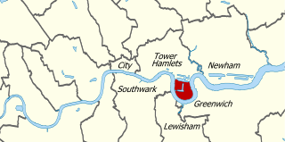
Stepney Green cavern is an underground junction which contains the junction where Crossrail divides into two branches: one to Shenfield and one to Abbey Wood. It is located below Stepney Green Park.

References

  1. 1 2 3 "Stepney Green – Crossrail Update and Implications" (PDF). Tower Hamlets Council. 30 March 2011. Archived from the original (PDF) on 2016-03-04.
  2. "The Mayor and Cabinet". www.towerhamlets.gov.uk. Archived from the original on 10 November 2012. Retrieved 15 January 2022.
  3. 1 2 Winfield, Nigel (1986). Stepping Stones: Community Farm Project in Stepney, East London. UK: British Association of Settlements and Social Action Centres. p. 32. ISBN   0950345253.
  4. Westman, Andrew. "Structures "Structures at King John Street, Stepney Green, London E1 (Stepney College and Stepney Meeting, or Congregational Church)"". Architectural and historical appraisal. Museum of London Archaeology Service. Archived from the original on September 23, 2015. Retrieved 20 December 2012.
  5. "Archaeology at Stepney Green Park and Stepney City Farm" (PDF). Cross Rail. Retrieved 2 January 2013.
  6. "Politics and puritans - Crossrail". www.crossrail.co.uk. Archived from the original on 5 June 2013. Retrieved 15 January 2022.
  7. "Ashes to asha: January 2009". www.hopeasha.org.uk. Archived from the original on 20 April 2012. Retrieved 15 January 2022.
  8. "City Farm Review: Stepney City Farm". www.ianvisits.co.uk. 2 May 2011.
  9. "All Official Legal documents for STEPNEY CITY FARM". www.companiesintheuk.co.uk. Archived from the original on 31 December 2013. Retrieved 15 January 2022.
  10. "Our History". Stepney City Farm. 14 August 2013.
  11. "The volunteers and animals of Stepney City Farm are getting used to life with Crossrail - News - London 24". www.london24.com. Archived from the original on 4 February 2011. Retrieved 15 January 2022.
  12. "London's centre for the traditional craft of Green Woodwork". The Green Wood Guild. Retrieved 22 April 2017.
  13. "BBC One - the Farmers' Country Showdown, Series 7, Lambeth Country Show".
  14. "BBC One - the Farmers' Country Showdown - Available now".
  15. "Crossrail Construction programme - Crossrail". Archived from the original on 2015-05-01. Retrieved 2015-05-01.
  16. "Archaeological dig opened up in Stepney Green - Crossrail". www.crossrail.co.uk. Archived from the original on 22 June 2013. Retrieved 15 January 2022.
  17. "Breakthrough as tunnelling giant Elizabeth arrives at Stepney Green Cavern". Crossrail. 29 December 2022. Archived from the original on November 10, 2013.
  18. "Meeting of the KING GEORGE'S FIELD CHARITY BOARD" (PDF). Tower Hamlets Council. 20 February 2013. Archived from the original (PDF) on 2016-03-03.
  19. "Stepney City Farm officially opens new buildings following major Crossrail funded improvements". Crossrail. 29 December 2022. Archived from the original on December 24, 2013.
  20. Odeen-Isbister, Sara. "Sad farewell to Stepney cows bound for pastures in the sky". East London Advertiser.
  21. 1 2 Brooke, Mike. "MP Jim Fitzpatrick fails to save pet cows Lloyd and Leila at Stepney Farm". East London Advertiser.
  22. "Keeping farmed animals: Cattle identification and registration - GOV.UK". www.gov.uk.

51°31′02″N0°02′36″W / 51.517155°N 0.043302°W / 51.517155; -0.043302