
The River Garnock, the smallest of Ayrshire's six principal rivers, has its source on the southerly side of the Hill of Stake in the heart of the Clyde Muirshiel Regional Park. About a mile and a half south of this starting point the untested stream tumbles over the Spout of Garnock, the highest waterfall in Ayrshire, once thought to be the river's origin. The river then continues, for a total length of 20 miles (32 km) or so, through the towns of Kilbirnie, Glengarnock, Dalry and Kilwinning to its confluence with the River Irvine at Irvine Harbour.

Stanecastle was a medieval barony and estate in North Ayrshire, Scotland, first mentioned in 1363 and now part of the Irvine New Town project. Its nearest neighbours are Bourtreehill and Girdle Toll.

Kerelaw Castle is a castle ruin. It is situated on the coast of North Ayrshire, Scotland in the town of Stevenston.

Eglinton Castle was a large Gothic castellated mansion in Kilwinning, North Ayrshire, Scotland.

The River Irvine is a river that flows through southwest Scotland. Its watershed is on the Lanarkshire border of Ayrshire at an altitude of 810 feet (250 m) above sea-level, near Loudoun Hill, Drumclog, and 7 miles SW by W of Strathaven. It flows 29+1⁄2 mi (47.5 km) westward, dividing the old district of Cunninghame from that of Kyle, until it reaches the sea via Irvine Harbour in the form of the Firth of Clyde, and flows into Irvine Bay by the town of Irvine. It has many tributaries, some of which form parish, district and other boundaries.
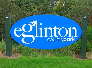
Eglinton Country Park is located on the grounds of the old Eglinton Castle estate in Kilwinning, North Ayrshire, Scotland. Eglinton Park is situated in the parish of Kilwinning, part of the former district of Cunninghame, and covers an area of 400 ha ([98 acres ] of which are woodland. The central iconic feature of the country park is the ruined Eglinton Castle, once home to the Eglinton family and later the Montgomeries, Earls of Eglinton and chiefs of the Clan Montgomery. Eglinton Country Park is managed and maintained by North Ayrshire Council and its Ranger Service.
Benslie is a small village in North Ayrshire, in the parish of Kilwinning, Scotland. Map reference NS 336 429.
Fergushill is a small community in North Ayrshire, Parish of Kilwinning, Scotland. The Barony of Fergushill was held by the Fergushill family of that Ilk and the area has a complex history.
Kilmaurs Place, The Place or Kilmaurs House, is an old mansion house and the ruins of Kilmaurs Tower grid reference NS41234112 are partly incorporated, Kilmaurs, East Ayrshire, Scotland. The house stands on a prominence above the Carmel Water and has a commanding view of the surrounding area. Once the seat of the Cunningham Earls of Glencairn it ceased to be the main residence after 1484 when Finlaystone became the family seat. Not to be confused with Kilmaurs Castle that stood on the lands of Jocksthorn Farm.

Montgreenan is an estate in North Ayrshire, Parish of Kilwinning, Scotland. The Lugton Water runs through the policies and farmland of Montgreenan. Nearby are the hamlets of Torranyard and Auchentiber.
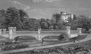
The Eglinton Tournament Bridge is a bridge located within Eglinton Country Park near Kilwinning, North Ayrshire, Scotland. The bridge crosses the Lugton Water a short distance northwest of Eglinton Castle and was named after the Eglinton Tournament of 1839. The castle and surrounding grounds were once home to the Montgomerie family, Earls of Eglinton and chiefs of the Clan Montgomery.

During the years 1781–1782, at the age of 23, Robert Burns (1759–1796) lived in Irvine, North Ayrshire for a period of around 9 months, whilst learning the craft of flax-dressing from Alexander Peacock, who may have been his mother's half-brother, working at the heckling shop in the Glasgow Vennel. Dr John Cumming of Milgarholm, a provost of Irvine, claimed that he had invited Burns to come to Irvine to learn flax dressing. During this time he made a number of acquaintances, befriended several locals and took regular walks into the Eglinton Woods via the old Irvine to Kilwinning toll road and the Drukken or Drucken (Drunken) Steps. Steps over the Red Burn and back via the site of Saint Brides or Bryde's Well at Stanecastle. Burns had several other connections with the Eglinton Estate and other branches of the Montgomerie family. He probably left in March 1782.

The Drukken, Drucken Steps or Drunken Steps were stepping stones across the Red Burn in Irvine, North Ayrshire, Scotland and are associated with Scotland's national poet, Robert Burns. Drukken is used on the commemorative cairn plaque, but Druken or Drucken may also be used.

The Eglinton Castle estate was situated at Irvine, on the outskirts of Kilwinning, North Ayrshire, Scotland in the former district of Cunninghame. Eglinton Castle, was once home to the Montgomeries, Earls of Eglinton and chiefs of the Clan Montgomery. Eglinton Country Park now occupies part of the site.
Failford is a hamlet in South Ayrshire, Scotland. It is 4 kilometres (2.5 mi) west of Mauchline, where the Water of Fail flows into the River Ayr.

A ford is a shallow place with good footing where a river or stream may be crossed by wading, or inside a vehicle getting its wheels wet. A ford may occur naturally or be constructed. Fords may be impassable during high water. A low-water crossing is a low bridge that allows crossing over a river or stream when water is low but may be treated as a ford when the river is high and water covers the crossing.
Littlestane Loch, was situated in the mid-Ayrshire clayland near Stanecastle, Irvine, North Ayrshire, Scotland. It is nowadays (2011) only visible as an area of permanent water in the Scottish Wildlife Trust Sourlie Nature Reserve. The loch was natural, sitting in a hollow created by glaciation. The loch waters outflow was via the Red Burn that flows into the River Garnock. The site of Littlestane Loch site is partly built over and much of the site is now public open space lying within the Parish of Girdle Toll.
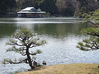
Kiyosumi Garden is a traditional Japanese stroll garden located in Fukagawa, Tokyo. It was constructed along classic principles in 1878–85, during the Meiji Period, by the shipping financier and industrialist Iwasaki Yatarō. By subtle hints in path construction and placement the visitor is led on a walk around the lake. Water-worn boulders were brought in from all over Japan, to give the garden its character; hills and dry waterfalls were constructed with them and two sequences of them form stepping-stones (isowatari) across small inlets of the lake, which almost completely fills the garden, allowing a pathway of many picturesque episodes around its perimeter. In fact only a narrow band of perimeter planting screens the garden from the structures along Kiyosumi Dori. There are three big islands and a teahouse on the pond. The garden covers an area of about 81,000 square metres.

Haugh or The Haugh is a small village or hamlet in East Ayrshire, Parish of Mauchline, Scotland. The habitation is situated about two and a half miles downstream from Catrine, on the north bank of the River Ayr. The River Ayr Way runs through the village.
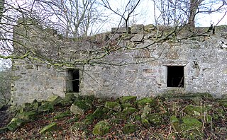
Haining Place or The Haining in the Parish of Kilmarnock lies near an old fording place across the Cessnock Water in East Ayrshire, Parish of Riccarton, Scotland. Hanyng (sic) was the caput or laird's dwelling of the Barony of Haining-Ross with a tower house or keep located in a defensive position on a high promontory of land, half encircled by the river. Later Haining Place may have been a dower house, then a tenanted farm, finally being used as farm workers accommodation. Haining Place is now a ruin following a fire. The old farm of Haining Mains is still located nearby.


