Stickney, South Dakota

Last updated

Stickney, South Dakota
Lincoln House, Stickney, SD, from E 1.jpg
Aurora County South Dakota Incorporated and Unincorporated areas Stickney Highlighted.svg
Location in Aurora County and the state of South Dakota
Coordinates: 43°35′21″N98°26′15″W / 43.58917°N 98.43750°W / 43.58917; -98.43750
Country United States
State South Dakota
County Aurora
Incorporated1905 [1]
Area
[2]
  Total0.27 sq mi (0.70 km2)
  Land0.27 sq mi (0.70 km2)
  Water0.00 sq mi (0.00 km2)
Elevation
[3]
1,644 ft (501 m)
Population
 (2020) [4]
  Total321
  Density1,197.76/sq mi (461.72/km2)
Time zone UTC-6 (Central (CST))
  Summer (DST) UTC-5 (CDT)
ZIP code
57375
Area code 605
FIPS code 46-61700 [5]
GNIS feature ID1267592 [3]
Website www.stickneysd.com

Stickney is a town in Aurora County, South Dakota, United States. The population was 321 at the 2020 census. [6]

Contents

History

The town was named for J.B. Stickney, an official with the Milwaukee Railroad. [7] [8] The town was platted and incorporated in 1905 and a post office was established November 17, 1905. [1] [7]

The William P. Smith house, now on the National Register of Historic Places, was built in 1914.

Geography

According to the United States Census Bureau, the town has a total area of 0.27 square miles (0.70 km2), all land. [9]

Demographics

Historical population
CensusPop.Note
1910 310
1920 38624.5%
1930 4126.7%
1940 361−12.4%
1950 3887.5%
1960 45617.5%
1970 421−7.7%
1980 409−2.9%
1990 323−21.0%
2000 3343.4%
2010 284−15.0%
2020 32113.0%
U.S. Decennial Census [10] [4]

2010 census

As of the census [11] of 2010, there were 284 people, 132 households, and 79 families residing in the town. The population density was 1,051.9 inhabitants per square mile (406.1/km2). There were 152 housing units at an average density of 563.0 per square mile (217.4/km2). The racial makeup of the town was 98.9% White and 1.1% Asian. Hispanic or Latino of any race were 0.4% of the population.

There were 132 households, of which 22.7% had children under the age of 18 living with them, 53.0% were married couples living together, 4.5% had a female householder with no husband present, 2.3% had a male householder with no wife present, and 40.2% were non-families. 38.6% of all households were made up of individuals, and 24.3% had someone living alone who was 65 years of age or older. The average household size was 2.15 and the average family size was 2.87.

The median age in the town was 47 years. 23.2% of residents were under the age of 18; 3.9% were between the ages of 18 and 24; 20.7% were from 25 to 44; 23.3% were from 45 to 64; and 28.9% were 65 years of age or older. The gender makeup of the town was 47.9% male and 52.1% female.

2000 census

As of the census [5] of 2000, there were 334 people, 156 households, and 92 families residing in the town. The population density was 1,254.1 inhabitants per square mile (484.2/km2). There were 169 housing units at an average density of 634.6 per square mile (245.0/km2). The racial makeup of the town was 99.70% White, 0.30% from other races. Hispanic or Latino of any race were 0.30% of the population.

There were 156 households, out of which 28.8% had children under the age of 18 living with them, 51.3% were married couples living together, 4.5% had a female householder with no husband present, and 41.0% were non-families. 39.7% of all households were made up of individuals, and 25.6% had someone living alone who was 65 years of age or older. The average household size was 2.11 and the average family size was 2.85.

In the town, the population was spread out, with 24.3% under the age of 18, 6.3% from 18 to 24, 19.8% from 25 to 44, 21.6% from 45 to 64, and 28.1% who were 65 years of age or older. The median age was 45 years. For every 100 females, there were 86.6 males. For every 100 females age 18 and over, there were 75.7 males.

The median income for a household in the town was $28,906, and the median income for a family was $42,083. Males had a median income of $27,344 versus $25,208 for females. The per capita income for the town was $15,936. About 5.6% of families and 9.1% of the population were below the poverty line, including 5.7% of those under age 18 and 19.1% of those age 65 or over.

See also

Related Research Articles

<span class="mw-page-title-main">Wolsey, South Dakota</span> Town in South Dakota, United States

Wolsey is a town in Beadle County, South Dakota, United States. The population was 459 at the 2020 census.

<span class="mw-page-title-main">Tabor, South Dakota</span> Town in South Dakota, United States

Tabor is a town in Bon Homme County, South Dakota, United States. The population was 407 at the 2020 census.

<span class="mw-page-title-main">Sinai, South Dakota</span> Town in South Dakota, United States

Sinai is a town in Brookings County, South Dakota, United States. The population was 99 at the 2020 census. Located there are a grainery, a post office, a bank, and a church.

<span class="mw-page-title-main">Claremont, South Dakota</span> Town in South Dakota, United States

Claremont is a town in Brown County, South Dakota, United States. The population was 108 at the 2020 census.

<span class="mw-page-title-main">Stratford, South Dakota</span> Town in South Dakota, United States

Stratford is a town in southern Brown County, South Dakota, United States. The population was 57 at the 2020 census.

<span class="mw-page-title-main">Westport, South Dakota</span> Town in South Dakota, United States

Westport is a town in western Brown County, South Dakota, United States. The population was 88 at the 2020 census.

<span class="mw-page-title-main">Mound City, South Dakota</span> Town in South Dakota, United States

Mound City is a town in and the county seat of Campbell County, South Dakota, United States. The population was 69 at the 2020 census.

<span class="mw-page-title-main">Bradley, South Dakota</span> Town in South Dakota, United States

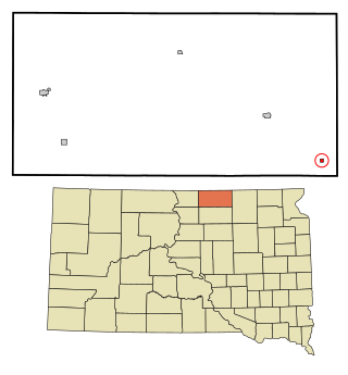
Bradley is a town in Clark County, South Dakota, United States. The population was 65 at the 2020 census.

<span class="mw-page-title-main">Florence, South Dakota</span> Town in South Dakota, United States

Florence is a town in northwestern Codington County, South Dakota, United States. It is part of the Watertown, South Dakota Micropolitan Statistical Area. The population was 337 at the 2020 census.

<span class="mw-page-title-main">Fairburn, South Dakota</span> Town in South Dakota, United States

Fairburn is a town in Custer County, South Dakota, United States. The population was 60 at the 2020 census.

<span class="mw-page-title-main">Onaka, South Dakota</span> Town in South Dakota, United States

Onaka is a town in Faulk County, South Dakota, United States. The population was 13 at the 2020 census.

<span class="mw-page-title-main">Strandburg, South Dakota</span> Town in South Dakota, United States

Strandburg is a town in southern Grant County, South Dakota, United States. The population was 63 at the 2020 census. Its name is derived from the town's founder, the Swedish John Strandburg.

<span class="mw-page-title-main">Wetonka, South Dakota</span> Town in South Dakota, United States

Wetonka is a town in McPherson County, South Dakota, United States. The population was 16 at the 2020 census.

<span class="mw-page-title-main">Crooks, South Dakota</span> City in South Dakota, United States

Crooks is a city in Minnehaha County, South Dakota, United States and is a suburb of Sioux Falls. The population was 1,362 at the 2020 census. Crooks was named New Hope until 1904. The town's present name honors W. A. Crooks, a local politician.

<span class="mw-page-title-main">Sherman, South Dakota</span> Town in South Dakota, United States

Sherman is a town in Minnehaha County, South Dakota, United States. The population was 81 at the 2020 census.

<span class="mw-page-title-main">Corona, South Dakota</span> Town in South Dakota, United States

Corona is a town in Roberts County, South Dakota, United States. The population was 69 at the 2020 census.

<span class="mw-page-title-main">Ortley, South Dakota</span> Town in South Dakota, United States

Ortley is a town in Roberts County, South Dakota, United States. The population was 50 according to the 2020 census.

<span class="mw-page-title-main">Peever, South Dakota</span> Town in South Dakota, United States

Peever is a town in Roberts County, South Dakota, United States. The population was 180 at the 2020 census.

<span class="mw-page-title-main">Tulare, South Dakota</span> Town in South Dakota, United States

Tulare is a town in Spink County, South Dakota, United States. The population was 211 at the 2020 census.

<span class="mw-page-title-main">Lowry, South Dakota</span> Town in South Dakota, United States

Lowry is a town in Walworth County, South Dakota, United States. The population was 10 at the 2020 census. The town is home to Lowry Pilgrim Community Church, Swan Creek Harness Shop, J & C Repair, Karst Service and a fire station. Lowry also has an abandoned school, and a post office, which closed to service in the early 1970s.

References

  1. 1 2 "SD Towns" (PDF). South Dakota State Historical Society . Retrieved February 15, 2010.
  2. "ArcGIS REST Services Directory". United States Census Bureau. Retrieved October 15, 2022.
  3. 1 2 U.S. Geological Survey Geographic Names Information System: Stickney, South Dakota
  4. 1 2 "Census Population API". United States Census Bureau. Retrieved October 15, 2022.
  5. 1 2 "U.S. Census website". United States Census Bureau . Retrieved January 31, 2008.
  6. "U.S. Census Bureau: Stickney town, South Dakota". www.census.gov. United States Census Bureau. Retrieved February 5, 2022.
  7. 1 2 Federal Writers' Project (1940). South Dakota Place-Names, Part I: State, County, and Town Names. Vermillion, South Dakota: University of South Dakota. p. 61. OCLC   34885177.
  8. "Profile for Stickney, South Dakota". ePodunk . Retrieved May 29, 2010.
  9. "US Gazetteer files 2010". United States Census Bureau. Archived from the original on January 12, 2012. Retrieved June 21, 2012.
  10. "Census of Population and Housing". Census.gov. Retrieved June 4, 2015.
  11. "U.S. Census website". United States Census Bureau . Retrieved June 21, 2012.