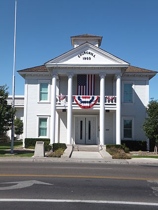
Churchill County is a county in the western U.S. state of Nevada. As of the 2020 census, the population was 25,516. Its county seat is Fallon. Named for Mexican–American War hero brevet Brigadier General Sylvester Churchill, the county was formed in 1861. Churchill County comprises the Fallon, NV Micropolitan Statistical Area. It is in northwestern Nevada. Churchill County is noteworthy in that it owns and operates the local telephone carrier, Churchill County Communications.

Fallon is a city in Churchill County in the U.S. state of Nevada. The population was 9,327 at time of the 2020 census. Fallon is the county seat of Churchill County and is located in the Lahontan Valley.
The Sand Springs Range is a short mountain range located in western Nevada in the United States within the Great Basin. It is approximately 10 miles (16 km) long and is in Churchill County. It separates Salt Wells from Fairview Valley. To the north, it is separated from the Stillwater Range by Sand Springs Pass. To the south is Gabbs Valley.

Austin is an unincorporated small town in, and former county seat of, Lander County, Nevada, United States. In 2020, the census-designated place of Austin had a population of 167. It is located on the western slopes of the Toiyabe Range at an elevation of 6,575 feet (2,004 m). U.S. Route 50 passes through the town.
Ragtown, Nevada, is a Churchill County ghost town of an abandoned 1854 trading post west of Fallon.

The Spirit Cave mummy is the oldest human mummy found in North America. It was discovered in 1940 in Spirit Cave, 13 miles (21 km) east of Fallon, Nevada, United States, by the husband-and-wife archaeological team of Sydney and Georgia Wheeler. He was said to be forty years old when he died. Analysis of the remains showed similarities to North and South American indigenous peoples and in 2016, the remains were repatriated to the Fallon Paiute-Shoshone Tribe of Nevada. The Spirit Cave mummy was one of the first to be dated using accelerated mass spectrometer radiocarbon dating. In turn, its discovery and analysis gave much insight and motivation of further research into the chronology of the western great basin.

Fort Churchill State Historic Park is a state park of Nevada, United States, preserving the remains of a United States Army fort and a waystation on the Pony Express and Central Overland Routes dating back to the 1860s. The site is one end of the historic Fort Churchill and Sand Springs Toll Road. The park is in Lyon County south of the town of Silver Springs, on U.S. Route 95 Alternate, eight miles (13 km) south of U.S. Route 50. Fort Churchill was designated a National Historic Landmark in 1961. A 1994 park addition forms a corridor along the Carson River.

State Route 116 is a state highway in Churchill County, Nevada, United States. Known as Stillwater Road, it connects the small town of Stillwater to U.S. Route 50 east of Fallon. The road was established by 1940 as SR 42, and was renumbered to SR 116 in 1976.
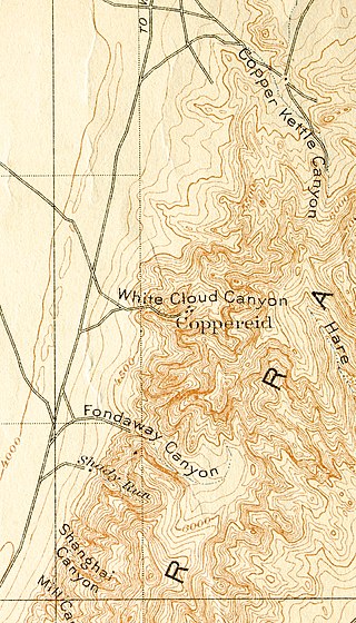
Coppereid, also known as White Cloud City is a ghost town in Churchill County, Nevada. It had a total population of 40 people. The site of Coppereid is south of Lovelock, east of the Carson Sink in the Stillwater Range.

State Route 118 is a state highway in Churchill County, Nevada. It serves the southeast portion of Fallon near northern edge of Naval Air Station Fallon. Prior to 1976, the route was designated as State Route 62.

U.S. Route 50 (US 50) is a transcontinental highway in the United States, stretching from West Sacramento, California, in the west to Ocean City, Maryland, on the east coast. The Nevada portion crosses the center of the state and was named "The Loneliest Road in America" by Life magazine in July 1986. The name was intended as a pejorative, but Nevada officials seized it as a marketing slogan. The name originates from large desolate areas traversed by the route, with few or no signs of civilization. The highway crosses several large desert valleys separated by numerous mountain ranges towering over the valley floors, in what is known as the Basin and Range province of the Great Basin.
Star City was a silver-mining boom town in present-day Pershing County, Nevada. It was located in the Star Mining District. It is now a ghost town.

Rawhide, Nevada was a town in Mineral County, Nevada, approximately 55 miles southeast of Fallon. The site of Rawhide has been dismantled by recent mining activity, with little or nothing remaining to be seen.
The Paiute-Shoshone Tribe of the Fallon Reservation and Colony is a federally recognized tribe of Northern Paiute and Western Shoshone Indians in Churchill County, Nevada. Their autonym is Toi Ticutta meaning "Cattail Eaters."

Dun Glen is a ghost town in Pershing County, Nevada, United States, 9 miles northeast of Mill City. Established in 1862, the mining camp soon became one of the largest towns in northern Nevada. By 1880, mining had declined and the town was abandoned. With a silver discovery in the area in 1908, the settlement attracted people and was re-named Chafey. Chafey was abandoned when mining operations stopped in 1913.
Schellbourne, formerly known as Fort Schellbourne and Schell Creek Station is a ghost town located in the Schell Creek Range in White Pine County in Nevada, United States, located 43 miles (69 km) north of Ely. The town was a stopover along the Central Overland Route, Pony Express and original routing of the Lincoln Highway. It is today Nevada Historical Marker number 51. The site was listed on the National Register of Historic Places in 1972. Its boundaries were increased in 1977.

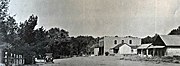
Fairview is a ghost town in Churchill County, Nevada, in the United States of America.
Jacobsville is a ghost town located in Lander County, Nevada, six miles west of Austin, on the east bank of Reese River, 0.7 mi N of US 50. Jacobsville was also known as Jacobs Spring, Jacobsville Station, Reese River and Reese River Station.
Mary Daisy White was a 20th-century American politician and business owner. One of the first women ever elected to the Nevada State Legislature, she represented rural Churchill County from November 1924 to November 1926. In 1953, she was declared to be the oldest Churchill County native still living in the county.


