
North America is a continent entirely within the Northern Hemisphere and almost all within the Western Hemisphere. It can also be described as a northern subcontinent of the Americas, or America, in models that use fewer than seven continents. It is bordered to the north by the Arctic Ocean, to the east by the Atlantic Ocean, to the west and south by the Pacific Ocean, and to the southeast by South America and the Caribbean Sea.

New MexicoSpanish pronunciation: [ˈnweβo ˈmexiko](listen)) is a state in the Southwestern region of the United States of America; its capital is Santa Fe, which was founded in 1610 as capital of Nuevo México, while its largest city is Albuquerque with its accompanying metropolitan area. It is one of the Mountain States and shares the Four Corners region with Utah, Colorado, and Arizona. New Mexico is also bordered by the state of Texas to the east-southeast, Oklahoma to the northeast, and the Mexican states of Chihuahua to the south and Sonora to the southwest. With an estimated population of 2,096,829 as of the July 1, 2019, U.S. Census Bureau estimate, New Mexico is the 36th largest state by population. With a total area of 121,590 sq mi (314,900 km2), it is the fifth-largest and sixth-least densely populated of the 50 states. Due to their geographic locations, northern and eastern New Mexico exhibit a colder, alpine climate, while western and southern New Mexico exhibit a warmer, arid climate.

Aztec mythology is the body or collection of myths of Aztec civilization of Central Mexico. The Aztecs were Nahuatl-speaking groups living in central Mexico and much of their mythology is similar to that of other Mesoamerican cultures. According to legend, the various groups who were to become the Aztecs arrived from the north into the Anahuac valley around Lake Texcoco. The location of this valley and lake of destination is clear – it is the heart of modern Mexico City – but little can be known with certainty about the origin of the Aztec. There are different accounts of their origin. In the myth the ancestors of the Mexica/Aztec came from a place in the north called Aztlan, the last of seven nahuatlacas to make the journey southward, hence their name "Azteca." Other accounts cite their origin in Chicomoztoc, "the place of the seven caves," or at Tamoanchan.

Cuba Township is a township in Becker County, Minnesota, United States. The population was 208 as of the 2000 census.

"Badges? We don't need no stinkin' badges!" is a widely quoted paraphrase of a line of dialogue from the 1948 film The Treasure of the Sierra Madre. That line was in turn derived from dialogue in the 1927 novel, The Treasure of the Sierra Madre, which was the basis for the film.

John Torrey was an American botanist, chemist, and physician. Throughout much of his career, Torrey was a teacher of chemistry, often at multiple universities, while at the same time pursuing botanical work. Dr. Torrey's botanical career focused on the flora of North America. His most renowned works include studies of the New York flora, the Mexican Boundary, the Pacific railroad surveys, as well as the uncompleted Flora of North America.

The State of Deseret was a provisional state of the United States, proposed in 1849 by settlers from The Church of Jesus Christ of Latter-day Saints in Salt Lake City. The provisional state existed for slightly over two years and was never recognized by the United States government. The name derives from the word for "honeybee" in the Book of Mormon.
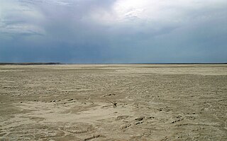
Grulla National Wildlife Refuge is located primarily in eastern New Mexico in Roosevelt County, southwest of the intersection of State Highway 88 and the Texas - New Mexico border about 25 miles southeast of Portales, New Mexico and southeast of the tiny community of Arch. A very small part of the refuge extends eastward into western Bailey County, Texas.

UTC−05:00 is an identifier for a time offset from UTC of −05:00. In North America, it is observed in the Eastern Time Zone during standard time, and in the Central Time Zone during the other eight months. The western Caribbean uses it year round.

The Apache–Sitgreaves National Forests are two 2.76-million-acre (11,169 km2) United States National Forests which run along the Mogollon Rim and the White Mountains in east-central Arizona and into the U.S. state of New Mexico. Both forests are managed as one unit by USDA Forest Service from the forests Supervisors Office in Springerville, Arizona. Apache–Sitgreaves has over 400 species of wildlife. With its high elevation and cool summer breezes it is a popular weekend destination from the hot desert for Phoenix, Arizona, residents. The forest is divided into 5 Ranger Districts that span almost 300 miles (480 km) from Clifton, Arizona in the east-central portion of Arizona to the eastern boundary of the Coconino National Forest in north-central Arizona. The Apache–Sitgreaves National Forest borders the western and northern borders of the Fort Apache Indian Reservation. It is located in parts of Greenlee, Apache, Navajo, and Coconino counties in eastern and east-central Arizona, and Catron County in western New Mexico. The more northwesterly Sitgreaves National Forest portion lies adjacent to the north side of the Fort Apache Indian Reservation and is located entirely in Arizona, within Navajo, Apache, and Coconino counties. It has a total area of 818,651 acres (3,313 km2). The more southeasterly and much larger Apache National Forest portion lies adjacent to the east side of the Fort Apache and the San Carlos Indian Reservations. It lies on both sides of the border with New Mexico, in Greenlee, Catron, and Apache counties. It has a total area of 1,813,601 acres (7,339 km2).

Wheeler Peak is the highest natural point in the U.S. state of New Mexico. It is located northeast of Taos and south of Red River in the northern part of the state, and just 2 miles (3.2 km) southeast of the ski slopes of Taos Ski Valley. It lies in the Sangre de Cristo Mountains, the southernmost subrange of the Rocky Mountains. The peak's elevation is 13,167 feet (4,013 m).
Cedar is the common name for cedar wood, used for several different trees that grow in different parts of the world.

The Treasure of the Sierra Madre is a 1948 American western adventure drama written and directed by John Huston. It is an adaptation of B. Traven's 1927 novel of the same name, set in the 1920s, in which, driven by their desperate economic plight, two young men, Fred C. Dobbs and Bob Curtin, join old-timer Howard in Mexico to prospect for gold.
Piracy on Falcon Lake refers to an increase in crime at the border between the United States and Mexico on Falcon Lake. The lake is a 60-mile (97 km) long reservoir of the Rio Grande that was constructed in 1954 and is a known drug smuggling route.
Stone Lake is a reservoir in Rio Arriba, New Mexico. Also known as Boulder Lake, it sits 5.5 mi (9 km) north of Stinking Lake and 18 mi (29 km) west northwest of Tierra Amarilla. The lake is located inside the Jicarilla Apache Reservation.

The Forks of Stinking is an unincorporated community located in Knox County, Kentucky, United States.
Stinking Creek is an unincorporated community in Campbell County, Tennessee, in the United States.
Brickellia rusbyi is a North American species of flowering plants in the daisy family. It is native to northern Mexico and the southwestern United States.

Crepis foetida is a European species of flowering plant in the daisy family with the common name stinking hawksbeard. It is widespread across much of Europe and Siberia, as well as being sparingly naturalized in scattered locations in the United States and Australia.
