Stiperstones

Last updated

Stiperstones
Manstone Rock from the south - geograph.org.uk - 1498515.jpg
Manstone Rock
Highest point
Elevation 536 m (1,759 ft)
Prominence 357 m (1,171 ft)
Parent peak Plynlimon
Listing Marilyn
Coordinates 52°34′55″N2°56′06″W / 52.58194°N 2.93500°W / 52.58194; -2.93500
Geography
England relief location map.jpg
Red triangle with thick white border.svg
Stiperstones
Location in England
Location Shropshire, England
Topo map OS Landranger 137
Shattered Cambrian quartzite at the Devil's Chair, Stiperstones Stiperstones by bladeflyer.jpg
Shattered Cambrian quartzite at the Devil's Chair, Stiperstones

The Stiperstones (Welsh : Carneddau Teon) [1] is a distinctive hill in Shropshire, England. The quartzite rock of the ridge formed some 480 million years ago. During the last Ice Age Stiperstones lay on the eastern margin of the Welsh ice sheet. The hill itself was not glaciated though glaciers occupied surrounding valleys and it was subject to intense freezing and thawing which shattered the quartzite into a mass of jumbled scree surrounding several residual rocky tors. [2] At 536 metres (1,759 ft) above sea level it is the second-highest hill in the county, surpassed only by Brown Clee Hill (540 metres (1,772 ft)). Stiperstones' 8-kilometre (5 mi) summit ridge is crowned by several jagged outcrops of rock, which may be seen silhouetted against the sky.

Contents

Geography

The Stiperstones is noted for its tors of quartzite. [3] The principal ones are named as follows, from north-east to south-west:

Manstone Rock is the highest of these at 536 metres (1,759 ft), and is topped with a trig point. The Devil's Chair is the largest and best known.

The Stiperstones ridge is a good place to view the upland landscape of the Shropshire Hills, particularly the Long Mynd to the east, and also gives extensive views towards the North Shropshire plain and the hills of Mid Wales.

Geology

The tors are formed from heavily faulted Ordovician age, grey-white quartzose sandstones known as the Stiperstones Quartzite Formation. This Arenigian age rock unit which dips steeply to the WNW is between 120 and 325m thick. The western slopes of the hill dropping to Stiperstones village are formed in the overlying Mytton Flag Formation, whereas the eastern slopes are formed in the underlying, and hence older, mudstones of the Shineton Shale Formation. Faulting narrows the outcrop of the Mytton Flags along the southern part of the Stiperstones ridge and the mudstones of the Hope Shale Formation with their interbedded volcaniclastics form much of the afforested ground to the west. The outcrop of the Stipertones Quartzite continues south-southwest to Black Rhadley Hill and peters out just beyond Heath Mynd. To the north-northeast, it continues as far as Pontesbury.

Much of the ground around the tors is covered by head, a gravelly and bouldery deposit arising during the present Quaternary period and deriving from the rocks immediately beneath it. There are also some isolated peat deposits in places. Of particular note is the patterned ground surrounding the tors; some of the best examples of the periglacial features known as stone stripes and polygons in England. [4] [5] [6]

Wildlife and conservation

The Stiperstones is a National Nature Reserve and Site of Special Scientific Interest (SSSI). [7] and is within the Shropshire Hills Area of Outstanding Natural Beauty. It is a haven for wildlife, with birds that are normally associated with upland areas present, including red grouse, Eurasian curlew, peregrine falcon and the rare ring ouzel.

Recently, a project called Back to Purple has commenced, to clear some of the hill of remaining plantations of coniferous and wooded areas, restoring the land to heather-based heath, with seasonal purple-flowering heather covering the summits around the tors and enhancing the views of the Stiperstones from the surrounding peaks and valleys. [8] Back to Purple is managed by a partnership of Natural England, Forest Enterprise and the Shropshire Wildlife Trust. Their work has so far seen removal of thousands of pine trees and other conifers, including the whole Gatten Plantation (still shown on OS maps) and the previously covered Nipstone Rock has emerged from hiding. Thousands of heather seedlings have been successfully planted to supplement natural regeneration. To balance this out and complement it further work below summit level has also aimed at restoring grasslands, rich in herbs, hay meadows, wet flushes which produce bog cotton, Heath Bedstraw and the rarer Mountain Pansy and natural woodlands.

Cultural references

The general area has a long history of lead mining, most notably during the Roman occupation of Britain. Several pigs of lead have been found nearby, and the tradition continued into Victorian times.

The area around the Stiperstones is rich in myths and folklore relating to the rocks of the Devil's Chair. According to one legend, the ghost of Wild Edric, a Saxon earl who held lands that were confiscated after 1066 and successfully defied the Normans, for a time at least, rides the hills whenever England is threatened by invasion. The Stiperstones feature in the literary works of Mary Webb, who drew it as The Diafol (translated from Welsh, "Devil's") Mountain in her novel The Golden Arrow (1916), [9] of children's author Malcolm Saville, and in a jazz work commissioned by Music at Leasowes Bank, written and performed by the Clark Tracey Quintet. D.H. Lawrence used the Stiperstones and the Devil's Chair in particular as a setting for his novel St Mawr (1925). [9]

The Half Man Half Biscuit album 90 Bisodol (Crimond) contains a track entitled "Descent of the Stiperstones".

An exaggerated version of the Stiperstones is included as a location in the 2020 video game Assassin's Creed Valhalla . [10]

Bog Mine and Visitor Centre

Until the early 20th century lead was mined at The Bog, just west of Stiperstones. The mine at The Bog and the adjacent Stiperstones outcrop were only viable because of a geological movement; over time the movement of the tectonic plates landed at this site, combined with the movement of the earth it crumpled the layers and the softest layers were then eroded away.[ clarification needed ] After mining stopped, the undisturbed remnants provided a range of wildlife habitats: birds nest in the old buildings, bats roost in the old mine tunnels, and reservoirs and ponds are ideal for aquatic life. [11]

The Bog Visitor Centre is the main facility for visitors to the Stiperstones. It is housed in the former village school and retains its old interior design. [11] It provides historical information about the past workers, mining, and present-day work to restore the landscape. Facilities at the centre include toilets and car parking (with facilities for the disabled including reserved parking, toilets and ramps). [12] Activities include walking, with two main circular walks called Mucklewick Walk and Flenny Bank Walk and a variety of riding routes. [12]

2012 fire

On 25 July 2012 part of the reserve was devastated by fire, said to have been a result of the sudden upturn in dry, hot weather coupled with the large amount of dry heather on the hills. More than 70 firemen battled the fire between 15.00 and 22.00 BST; smoke could be seen up to 10 miles away in the county town of Shrewsbury. Firefighters remained on site throughout the night because of the severity of the fire and the extent of the affected areas. [13] [14]

Related Research Articles

<span class="mw-page-title-main">Dartmoor</span> National park in South West England

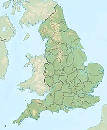
Dartmoor is an upland area in southern Devon, South West England. The moorland and surrounding land has been protected by National Park status since 1951. Dartmoor National Park covers 954 km2 (368 sq mi).

<span class="mw-page-title-main">National nature reserves in England</span>

National nature reserves in England are designated by Natural England as key places for wildlife and natural features in England. They were established to protect the most significant areas of habitat and of geological formations. NNRs are managed on behalf of the nation, many by Natural England itself, but also by non-governmental organisations, including the members of The Wildlife Trusts partnership, the National Trust, and the Royal Society for the Protection of Birds.

<span class="mw-page-title-main">Quartzite</span> Hard, non-foliated metamorphic rock

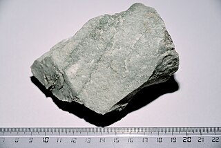
Quartzite is a hard, non-foliated metamorphic rock which was originally pure quartz sandstone. Sandstone is converted into quartzite through heating and pressure usually related to tectonic compression within orogenic belts. Pure quartzite is usually white to grey, though quartzites often occur in various shades of pink and red due to varying amounts of hematite. Other colors, such as yellow, green, blue and orange, are due to other minerals.

<span class="mw-page-title-main">Long Mynd</span> Heath and moorland plateau in Shropshire, England

The Long Mynd is a heath and moorland plateau that forms part of the Shropshire Hills in Shropshire, England. The high ground, which is common land and designated as an Area of Outstanding Natural Beauty, lies between the Stiperstones range to the west and the Stretton Hills and Wenlock Edge to the east. Much of it is owned by the National Trust, and is managed by the Longmynd Commoners.

<span class="mw-page-title-main">Shropshire Hills National Landscape</span> Area of Outstanding Natural Beauty in England

The Shropshire Hills National Landscape is a designated Area of Outstanding Natural Beauty (AONB) in Shropshire, England. It is located in the south of the county, extending to its border with Wales. Designated in 1958, the area encompasses 802 square kilometres (310 sq mi) of land primarily in south-west Shropshire, taking its name from the upland region of the Shropshire Hills. The A49 road and Welsh Marches Railway Line bisect the area north–south, passing through or near Shrewsbury, Church Stretton, Craven Arms and Ludlow.

<span class="mw-page-title-main">Titterstone Clee Hill</span>

Titterstone Clee Hill, sometimes referred to as Titterstone Clee or Clee Hill, is a prominent hill in the rural English county of Shropshire, rising at the summit to 533 metres (1,749 ft) above sea level.

<span class="mw-page-title-main">Radnor Forest</span> Rock dome in Mid Wales

Radnor Forest is a rock dome composed of Silurian shales, mudstones and limestone in the historic county of Radnorshire, Powys, Mid Wales. It is a forest in the medieval sense of the word. It lies within the Welsh Marches region since Offa's Dyke lies nearby to the east.

<span class="mw-page-title-main">Devil's Lake State Park (Wisconsin)</span> State Park in Sauk County, Wisconsin

Devil's Lake State Park is a state park located in the Baraboo Range in eastern Sauk County, just south of Baraboo, Wisconsin. It is around thirty-five miles northwest of Madison, and is on the western edge of the last ice-sheet deposited during the Wisconsin glaciation. The state park encompasses 9,217 acres (3,730 ha), making it the largest in Wisconsin. The state park is known for its 500-foot-high (150 m) quartzite bluffs along the 360-acre (150 ha) Devil's Lake, which was created by a glacier depositing terminal moraines that plugged the north and south ends of the gap in the bluffs during the last ice age approximately 12,000 years ago. The sand at the bottom of Devil's Lake is thought to be deposited by glaciers.

The geology of Shropshire is very diverse with a large number of periods being represented at outcrop. The bedrock consists principally of sedimentary rocks of Palaeozoic and Mesozoic age, surrounding restricted areas of Precambrian metasedimentary and metavolcanic rocks. The county hosts in its Quaternary deposits and landforms, a significant record of recent glaciation. The exploitation of the Coal Measures and other Carboniferous age strata in the Ironbridge area made it one of the birthplaces of the Industrial Revolution. There is also a large amount of mineral wealth in the county, including lead and baryte. Quarrying is still active, with limestone for cement manufacture and concrete aggregate, sandstone, greywacke and dolerite for road aggregate, and sand and gravel for aggregate and drainage filters. Groundwater is an equally important economic resource.

The Clee Hills are a range of hills in Shropshire, England near Ludlow, consisting of Brown Clee Hill 1,772 feet (540 m), the highest peak in Shropshire, and Titterstone Clee Hill 1,749 feet (533 m). They are both in the Shropshire Hills Area of Outstanding Natural Beauty.

<span class="mw-page-title-main">Shropshire Hills</span> Upland area in Shropshire, West Midlands

The Shropshire Hills are a dissected upland area and one of the natural regions of England. They lie wholly within the county of Shropshire and encompass several distinctive and well-known landmarks, such as the Long Mynd, Wenlock Edge, The Wrekin and the Clees.

<span class="mw-page-title-main">Hothfield Common</span>

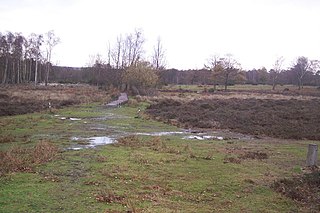
Hothfield Common is a 56.5-hectare (140-acre) biological Site of Special Scientific Interest north-east of Ashford in Kent. It is also a Local Nature Reserve, and is part of the 86-hectare (210-acre) Hothfield Heathlands nature reserve owned by Ashford Borough Council and managed by Kent Wildlife Trust.

<span class="mw-page-title-main">Mountains and hills of England</span>

The mountains and hills of England comprise very different kinds of terrain, from a mountain range which reaches almost 1,000 metres high, to several smaller areas of lower mountains, foothills and sea cliffs. Most of the major upland areas have been designated as Areas of Outstanding Natural Beauty (AONB) or national parks. The highest and most extensive areas are in the north and west, while the midlands, south-east and east of the country tend to be low-lying.

The Devil's Chair are urban legends about funerary or memorial sculpture in cemeteries.

<span class="mw-page-title-main">Helman Tor</span>

Helman Tor is a granite hill in mid Cornwall, UK with several separated tors, and is designated as a (non-statutory) County Geology Site. The hill also has a Scheduled Ancient Monument. Helman Tor is also the name of the largest nature reserve managed by the Cornwall Wildlife Trust which includes Breney Common and Red Moor. The Wildlife Trust aims to rewild the reserve, including potentially releasing beavers, as well as long-horn cattle and Cornish black pigs. Helman Tor, along with Breney Common, Red Moor and Belowda Beacon, is part of the Mid Cornwall Moors Site of Special Scientific Interest. It lies on the Saints' Way, a long-distance footpath completed in 1986.

<span class="mw-page-title-main">Poles Coppice countryside site</span>

Poles Coppice countryside site is an area of ancient oak woodland with disused quarry workings, located around 0.5 miles (1 km) south of Pontesbury, Shropshire. It is managed by Shropshire Council as a picnic spot and area for walking and recreation activities.

<span class="mw-page-title-main">The Bog</span>

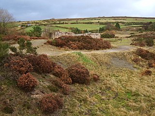
The Bog is a former mining community in Shropshire, England. It lies 6 miles (10 km) north of Bishops Castle, east of the A488, at grid reference SO355979. It was once a busy village with over 200 buildings. Now only a few remain. The local mines produced lead and barytes until the early 20th century.

<span class="mw-page-title-main">Catherton Common</span>

Catherton Common is a nature reserve of the Shropshire Wildlife Trust, between Cleehill and Cleobury Mortimer in Shropshire, England. It is heathland, designated a Site of Special Scientific Interest.

<span class="mw-page-title-main">Whitelee Moor</span>

Whitelee Moor is nature reserve of the Northumberland Wildlife Trust, in Northumberland, England, near Carter Bar. A large part of the moor is blanket bog.

References

  1. "National Landscape Character NLCA18 Shropshire Hills" (PDF). Natural Resources Wales. Retrieved 30 May 2021.
  2. Toghill, Peter (2006). Geology of Shropshire (Second ed.). Marlborough: The Crowood Press. pp. 237–243. ISBN   1861268033.
  3. "Stiperstones Introduction". Shropshiregeology.org.uk. Retrieved 26 July 2012.
  4. "GeoIndex Onshore". British Geological Survey. Retrieved 4 July 2020.
  5. "1:50000 Series England and Wales sheet 151, Welshpool, Bedrock & Superficial Deposits". Maps Portal. British Geological Survey. Retrieved 4 July 2020.
  6. "1:50000 series England and Wales sheet 165 Montgomery, Solid and Drift geology". Maps Portal. British Geological Survey. Retrieved 4 July 2020.
  7. "The Stiperstones (SSSI and National Nature Reserve)". Natural England. Archived from the original on 5 October 2013. Retrieved 4 September 2013.
  8. "Stiperstones appeal: a part of the Shropshire Wildlife Trust Site". Shropshirewildlifetrust.org.uk. 10 June 2007. Archived from the original on 10 June 2007. Retrieved 26 July 2012.
  9. 1 2 Dickins, Gordon (1987). An Illustrated Literary Guide to Shropshire. Shropshire Libraries. p. 116. ISBN   0-903802-37-6.
  10. "Assassin's Creed Valhalla made my home a magical wilderness". Eurogamer.net. 18 January 2021. Retrieved 31 March 2024.
  11. 1 2 "Information sources". The Bog Visitor Centre. Retrieved 4 September 2013.
  12. 1 2 "Bog mine and visitor centre – Stiperstones". Shropshire Council. Archived from the original on 22 September 2013. Retrieved 4 September 2013.
  13. "Fire at Stiperstones nature reserve". BBC News Shropshire. 24 July 2012. Retrieved 4 September 2013.
  14. "Crews put out fire at Stiperstones nature reserve". BBC News Shropshire. 25 July 2012. Retrieved 4 September 2013.