Related Research Articles
The Batswana, a term also used to denote all citizens of Botswana, refers to the country's major ethnic group. Prior to European contact, the Batswana lived as herders and farmers under tribal rule.

Botswana is a landlocked country located in Southern Africa, north of South Africa. Botswana occupies an area of 581,730 square kilometres (224,610 sq mi), of which 566,730 km2 (218,820 sq mi) are land. Botswana has land boundaries of combined length 4,347.15 kilometres (2,701.19 mi), of which the constituent boundaries are shared with Namibia, for 1,544 km (959 mi); South Africa 1,969 km (1,223 mi); Zimbabwe, 834 km (518 mi) and Zambia, 0.15 km (0.093 mi). Much of the population of Botswana is concentrated in the eastern part of the country.

Zimbabwe is a landlocked country in southern Africa lying wholly within the tropics. It straddles an extensive high inland plateau that drops northwards to the Zambezi valley where the border with Zambia is and similarly drops southwards to the Limpopo valley and the border with South Africa. The country has borders with Botswana 813 km, Mozambique 1,231 km, South Africa 225 km, Zambia 797 km and almost meets Namibia at its westernmost point.

The Limpopo River rises in South Africa, and flows generally eastwards through Mozambique to the Indian Ocean. The term Limpopo is derived from Rivombo (Livombo/Lebombo), a group of Tsonga settlers led by Hosi Rivombo who settled in the mountainous vicinity and named the area after their leader. The river is approximately 1,750 kilometres (1,087 mi) long, with a drainage basin 415,000 square kilometres (160,200 sq mi) in size. The mean discharge measured over a year is 170 m3 per second at its mouth. The Limpopo is the second largest river in Africa that drains to the Indian Ocean, after the Zambezi River.

Limpopo is the northernmost province of South Africa. It is named after the Limpopo River, which forms the province's western and northern borders. The capital and largest city in the province is Polokwane.

Gaza is a province of Mozambique. It has an area of 75,709 km2 and a population of 1,422,460, which is the least populous of all the provinces of Mozambique.
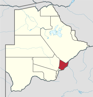
Kgatleng is one of the districts of Botswana, coterminous with the homeland of the Bakgatla people. Its capital is Mochudi, the hometown of protagonist Precious Ramotswe in Alexander McCall Smith's popular The No. 1 Ladies' Detective Agency series. According to the 2001 Census, Kgatleng had a population of 73,507 people.

Central is the largest of Botswana's districts in terms of area and population. It encompasses the traditional homeland of the Bamangwato people. Some of the most politically connected Batswana have come from the Central District, including former President Sir Seretse Khama, former President Festus Mogae, and former President Lt. General Seretse Ian Khama. The district borders the Botswanan districts of Chobe in the north, North-West in the northwest, Ghanzi in the west, Kweneng in southwest, Kgatleng in the south and North-East in the northeast, as well as Zimbabwe also in the northeast and South Africa in the southeast.

The Shashe River is a major left-bank tributary of the Limpopo River in Zimbabwe. It rises northwest of Francistown, Botswana and flows into the Limpopo River where Botswana, Zimbabwe and South Africa meet. The confluence is at the site of the Greater Mapungubwe Transfrontier Conservation Area.
The Kalanga or Bakalanga are a southern Bantu ethnic group mainly inhabiting Matebeleland in Zimbabwe, northeastern Botswana and Limpopo Province in South Africa. They are historically related to the Nambya, Karanga and Venda.

The N11 is a national route in South Africa which runs from the Botswana border at Groblersbrug, through Mokopane, Middelburg, Ermelo and Newcastle to end at the N3 just after Ladysmith.
Drainage Basin A, is one of the drainage basins of South Africa. The main river in this system is the Limpopo River. It is subdivided into 9 sub-drainage basins.

Musina Local Municipality is located in the Vhembe District Municipality of Limpopo province, South Africa, and is the northernmost local municipality in South Africa. It borders on Botswana and Zimbabwe. The seat of Musina Local Municipality is Musina.

The Notwane River is a river in southeastern Botswana. Certain sections of its course form the international boundary with South Africa. Its mouth is at the head of the Limpopo River. It has a catchment area of 18,053 square kilometers.

The Lotsane River is a river in southeastern Botswana. It is a seasonal left hand tributary of the Limpopo River and has a catchment area of 9,748 square kilometers.
Limpopo Valley Airfield is an airport serving the Northern Tuli Game Reserve, an area of public and private game reserves in eastern Botswana. The airport is owned by Mashatu Game Reserve with a superseded ICAO code of FBLV.

The border between South Africa and Zimbabwe is 225 kilometres (140 mi) long, and follows the median line of the Limpopo River.
Groblersbrug is a border crossing between South Africa and Botswana on the Limpopo River in Limpopo. On the Botswana side, the border post is known as Martin's Drift.

Baltimore is a small township situated on the N11 Highway in the Limpopo province of South Africa. It is a main stop-over for the Groblersbrug Border Post with Botswana.
The Soutpansberg Military Area (SMA) Headquarters was situated in Messina in the Northern Province of South Africa. The size of the area for which the SMA was responsible for was approximately 4,040 square kilometres (1,560 sq mi).