
Seven Corners is a commercial center and census-designated place (CDP) in Fairfax County, Virginia, United States. The population was 9,255 at the 2010 census. Seven Corners has a "Falls Church" mailing address but is not within Falls Church's city limits. The area got its name from the intersection of State Route 7, U.S. Route 50, State Route 613, State Route 338 and Wilson Boulevard. The junction of these four roads once created seven corners.

An intersection or an at-grade junction is a junction where two or more roads converge, diverge, meet or cross at the same height, as opposed to an interchange, which uses bridges or tunnels to separate different roads. Major intersections are often delineated by gores and may be classified by road segments, traffic controls and lane design.

Traffic lights, traffic signals, or stoplights – also known as robots in South Africa and Namibia – are signalling devices positioned at road intersections, pedestrian crossings, and other locations in order to control the flow of traffic.

A street is a public thoroughfare in a built environment. It is a public parcel of land adjoining buildings in an urban context, on which people may freely assemble, interact, and move about. A street can be as simple as a level patch of dirt, but is more often paved with a hard, durable surface such as tarmac, concrete, cobblestone or brick. Portions may also be smoothed with asphalt, embedded with rails, or otherwise prepared to accommodate non-pedestrian traffic.

A square is an open public space used for various activities. Squares are not necessarily a true geometric square. Most squares are hardscapes suitable for open markets, concerts, political rallies, and other events that require firm ground.
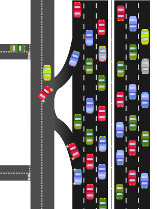
A frontage road is a local road running parallel to a higher-speed, limited-access road. A frontage road is often used to provide access to private driveways, shops, houses, industries or farms. Where parallel high-speed roads are provided as part of a major highway, these are also known as local lanes. Sometimes a similar arrangement is used for city roads; for example, the collector portion of Commonwealth Avenue in Boston, Massachusetts, is known as a carriage road.

Harvard Square is a triangular plaza at the intersection of Massachusetts Avenue, Brattle Street and John F. Kennedy Street near the center of Cambridge, Massachusetts, United States. The term "Harvard Square" is also used to delineate the business district and Harvard University surrounding that intersection, which is the historic center of Cambridge. Adjacent to Harvard Yard, the historic heart of Harvard University, the Square functions as a commercial center for Harvard students, as well as residents of western Cambridge, the western and northern neighborhoods and the inner suburbs of Boston. The Square is served by Harvard station, a major MBTA Red Line subway and a bus transportation hub.

Edge city is a term that originated in the United States for a concentration of business, shopping, and entertainment outside a traditional downtown or central business district, in what had previously been a suburban residential or rural area. The term was popularized by the 1991 book Edge City: Life on the New Frontier by Joel Garreau, who established its current meaning while working as a reporter for The Washington Post. Garreau argues that the edge city has become the standard form of urban growth worldwide, representing a 20th-century urban form unlike that of the 19th-century central downtown. Other terms for these areas include suburban activity centers, megacenters, and suburban business districts. These districts have now developed in many countries.

A pedestrian scramble is a type of traffic signal movement that temporarily stops all vehicular traffic, thereby allowing pedestrians to cross an intersection in every direction, including diagonally, at the same time.

A single-point urban interchange, also called a single-point interchange (SPI) or single-point diamond interchange (SPDI), is a type of highway interchange. The design was created in order to help move large volumes of traffic through limited amounts of space efficiently.
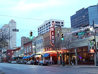
Sixth Street is a historic street and entertainment district in Austin, Texas, located within the city's urban core in downtown Austin. Sixth Street was formerly named Pecan Street under Austin's older naming convention, which had east–west streets named after trees and north–south streets named after Texas rivers.

Newton is a small suburb of Auckland, New Zealand, under the local governance of the Auckland Council. It had a population of 1,641 in the 2013 census.

A collector road or distributor road is a low-to-moderate-capacity road which serves to move traffic from local streets to arterial roads. Unlike arterials, collector roads are designed to provide access to residential properties. Rarely, jurisdictions differentiate major and minor collector roads, the former being generally wider and busier.
A streetcorner or street corner is the location beside a road intersection.

An all-way stop – also known as a four-way stop – is a traffic management system which requires vehicles on all the approaches to a road intersection to stop at the intersection before proceeding through it. Designed for use at low traffic-volume locations, the arrangement is common in the United States, Canada, Mexico, South Africa, and Liberia, as well as in a number of, usually rural, locations in Australia where visibility on the junction approaches is particularly poor. The stop signs at such intersections may be supplemented with additional plates stating the number of approaches.
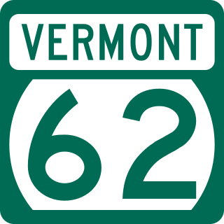
Vermont Route 62 (VT 62) is a short 4.519-mile-long (7.273 km) state highway in Washington County, Vermont, United States. The road was designed to serve as a connector between Interstate 89 (I-89) and the city of Barre, akin to the three-digit spur interstates that are present throughout the United States. Unlike those roads, however, VT 62 is not a fully grade separated limited-access highway, having five signaled intersections with local roads over the course of its route.

East 105th Street and Euclid Avenue was at one time the most famous intersection in the city of Cleveland, Ohio. The legendary commercial junction consists of several blocks from East to West between 107th Street and 105th Street.
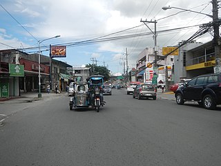
Doña Soledad Avenue is an east-west route in the southern Metro Manila city of Parañaque, Philippines. It traverses barangays Don Bosco and Moonwalk, both located in northeastern Parañaque. It runs from its intersection with E. Rodriguez Avenue in the eastern edge of Moonwalk. The road continues to the east, entering Better Living Subdivision. It then curves north for a few blocks, then turns east and heads for its terminus at Bicutan Exit of South Luzon Expressway (SLEX) and Skyway. East of SLEX, the avenue continues as East Service Road into San Martin de Porres and Lower Bicutan in Taguig, where it then continues as General Santos Avenue.

A protected intersection or protected junction, also known as a Dutch-style junction, is a type of at-grade road junction in which cyclists and pedestrians are separated from cars. The primary aim of junction protection is to help pedestrians and cyclists be and feel safer at road junctions.

Terminology related to road transport—the transport of passengers or goods on paved routes between places—is diverse, with variation between dialects of English. There may also be regional differences within a single country, and some terms differ based on the side of the road traffic drives on. This glossary is an alphabetical listing of road transport terms.

