
Church Stretton is a market town in Shropshire, England, 13 miles (21 km) south of Shrewsbury and 15 miles (24 km) north of Ludlow. The population in 2011 was 4,671.

All Stretton is a village and civil parish in Shropshire, England.

Stretton is a large village and civil parish in Staffordshire, England. It is situated on the northern outskirts of Burton upon Trent and is effectively a suburb of that town. The name is Old English and means Street Town and comes it being on the Roman road called Ryknild Street. The population of the parish at the 2001 census was 8,355, increasing to 8,611 at the 2011 Census.
Stretton Sugwas is a village and civil parish in Herefordshire, England, about 4 miles (6.4 km) northwest of Hereford. The parish also includes the hamlet of Swainshill. The population of this Civil Parish at the 2011 census was 505. Stretton comes from the Roman road which passes east–west through the village, Sugwas derives from Sugwas Pool. In 1087 the village was held by Roger de Lacy and consisted of two and a half hides paying geld, in demesne there was 2 ploughs, 1 villan, 9 bordars, 4 oxmen, and 2 radknights, as well as a mill rendering 32d. The village had increased in value from 40 to 50s from the time of the conquest to that of Domesday. The village lies within the ancient Hundred of Grimsworth

Stretton en le Field is a small village and civil parish in the North West Leicestershire district of Leicestershire, England. It is about 7 miles/11 km south-west of Ashby de la Zouch, and according to the 2001 census the parish had a population of 36. At the 2011 census the population remained less than 100 and was included in the civil parish of Chilcote. Stretton Bridge carries the A444 road across the River Mease, which forms the parish's northern boundary. Stretton en le Field is among the Thankful Villages suffering no fatalities in the Great War of 1914–1918: eleven men went from the village to fight and all returned.

Stretton is a village and civil parish in Warrington, Cheshire, England. The parish includes the village of Lower Stretton. It is at the very southern tip of Warrington, about 4 miles (6.4 km) south of the town centre. It has a large hotel and is the site of Warrington's private hospital, run by Spire Healthcare. The village is near junction 10 of the M56 motorway.

King's Norton is a village and civil parish in the Harborough district of Leicestershire, England. It is situated to the east of Leicester, and about 2 1⁄2 miles (4 km) south-west from Billesdon. According to the 2001 census the parish had a population of 69. At the 2011 census the population remained less than 100 and is included in the civil parish of Gaulby.
St Cuthbert Without, or simply St Cuthbert, is a civil parish within the City of Carlisle in Cumbria, England.

Stretton-on-Fosse is a small village and civil parish with fewer than 200 houses, most built of Cotswold stone or locally-made red brick, situated on the Warwickshire-Gloucestershire border on the fringe of the Cotswold Hills. It is governed by the Stratford-on-Avon District council. The population of the civil parish taken at the 2011 census was 439. By comparison, the 1931 population was 282. The village has about 200 buildings, made of Cotswold stone or locally made red bricks. Of these, 18 are Grade II Listed by Historic England. At one time, the village was known as Stretton upon Fosse.

Cliburn is a village and civil parish in the Eden district of Cumbria, England. The civil parish includes the hamlet of Town Head. In 2001 the population was 204, increasing to 274 at the 2011 Census.

Leebotwood is a small village and civil parish in Shropshire, England. It is about 9 miles (14 km) south of Shrewsbury and 3.5 miles (5.6 km) north of Church Stretton.

Hepworth is a village and civil parish in the St Edmundsbury district of the English county of Suffolk. Nearby settlements include the villages of Stanton and Barningham. For transport there is the A143 road nearby. Hepworth has a place of worship. The population at the 2011 Census was 536.

Canon Pyon is a village and civil parish on the A4110 road in Herefordshire, England. The population of the parish at the 2011 Census was 542. The civil parish includes the settlement of Westhope.

Clyst St Lawrence is a village and civil parish about 8 miles north-east of the city of Exeter in the county of Devon, England. Historically it formed part of Cliston Hundred. The parish is in the East Devon district and is surrounded, clockwise from the north, by the parishes of Clyst Hydon, Whimple and the large parish of Broad Clyst. In 2001 its population was 105, little changed from the 113 people who lived there in 1901.
Stretton is a small, dispersed village in South Staffordshire, England. It is just north of the A5 road in the civil parish of Lapley, Stretton and Wheaton Aston
Lapley, Stretton and Wheaton Aston is a civil parish in South Staffordshire, England. The population of the civil parish at the 2011 census was 2,548.

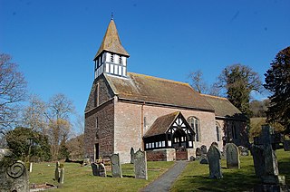
St Laurence's Church is in Church Street, Church Stretton, Shropshire, England. It is an active Anglican parish church in the deanery of Condover, the archdeaconry of Ludlow, and the diocese of Hereford. Its benefice is united with those of St Michael and All Angels, All Stretton, and All Saints, Little Stretton to form the parish of Church Stretton. The church is recorded in the National Heritage List for England as a designated Grade I listed building.
Stretton is a civil parish in the Borough of Warrington in Cheshire, England. It contains nine buildings that are recorded in the National Heritage List for England as designated listed buildings, all of which are listed at Grade II. This grade is the lowest of the three gradings given to listed buildings and is applied to "buildings of national importance and special interest". The M56 motorway runs through the parish in an east-west direction, and the A49 road runs in a north-south direction. The northern part of the parish is residential, and the rest is mainly rural. Apart from St Matthew's Church and a milestone, the listed buildings are related either to houses or to farming.
Eggleton is a small civil parish in Herefordshire, England. Its main centres of population are Lower Eggleton and Upper Eggleton.
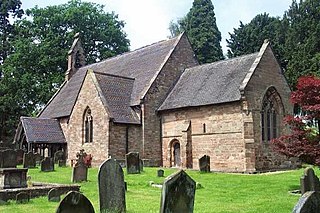
Castle Frome is a village and civil parish in the county of Herefordshire, England, and is 10 miles (16 km) north-east from the city and county town of Hereford. The closest large town is the market town of Bromyard, 5 miles (8 km) to the north. The Norman font in Castle Frome church is "one of the outstanding works of the Herefordshire school".
