Subak (irrigation)

Last updated

Subak
UNESCO World Heritage Site
Batukaru1.JPG
Balinese altar at rice terraces near Gunung Batukaru
Official nameCultural Landscape of Bali Province: the Subak System as a Manifestation of the Tri Hita Karana Philosophy
Location Bali, Indonesia
Includes
  1. Supreme Water Temple Pura Ulun Danu Batur
  2. Lake Batur
  3. Subak Landscape of Pekerisan Watershed
  4. Subak Landscape of Catur Angga Batukaru
  5. Royal Water Temple Pura Taman Ayun
Criteria Cultural: (iii), (v), (vi)
Reference 1194rev
Inscription2012 (36th Session)
Area19,519.9 ha (48,235 acres)
Buffer zone1,454.8 ha (3,595 acres)
Coordinates 8°15′33″S115°24′10″E / 8.25917°S 115.40278°E / -8.25917; 115.40278
Indonesia Bali location map.svg
Red pog.svg
Location of Subak in Bali
Indonesia relief location map.jpg
Red pog.svg
Subak (irrigation) (Indonesia)

Subak is the water management (irrigation) system for the paddy fields on Bali island, Indonesia. It was developed in the 9th century. For the Balinese, irrigation is not simply providing water for the plant's roots, but water is used to construct a complex, pulsed artificial ecosystem [1] that is at the same time autonomous and interdependent. [2] The system consists of five terraced rice fields and water temples covering nearly 20,000 hectares (49,000 acres). The temples are the main focus of this cooperative water management, known as subak.

Contents

Some history and etymology

The subak system was started some time during the 9th century, when political Bali was a patchwork of kingdoms - which gives food for though on both aspects: the physical feat of creating such a wondrous landscape, and the profound social impact from the cooperation it imposed as a sine qua non between entities such as kingdoms. [3]

The first known written record dates from around the 11th century: a text from that period cites it under the name kasuwakara, which later became suwak and then subak. But other documents from the same period mention that the system is linked to the Besakih Temple, which suggests that subak predates the 11th century. [3]

Structure and organisation of the subak system

Subak is a traditional, ecologically sustainable [4] irrigation system that binds Balinese agrarian society together within the village's bale banjar [lower-alpha 1] (community center) and Balinese temples.

Subak components are the forests that protect and funnel the water supply; [3] the terraced paddies or rice fields landscape; the system of canals, tunnels and weirs; the temples of varying size and importance that mark either the source of water or its passage through the temple on its way downhill to irrigate subak land — each of these temples corresponding to a drainage basin. Rice, the water network required to grow rice, and the subak cooperative that controls that water network, have together shaped the landscape over the past thousand years. [9]

As of 2019 the number of subak is estimated at 1,559. [10] [lower-alpha 2] Between 50 and 400 farmers manage the water supply from one source of water. [9]

The traditional schedules have important effects on both water sharing and pest control. The logistics of the traditional system of water sharing mean that the farmers must synchronize their crops. This creates brief fallow periods over large areas and deprives pest populations of their habitat, thus considerably reducing their numbers and maintaining these at a sustainable level. The success of fallow periods as a pest control technique depends on the extent and duration of the fallow period: all of the fields in a large area must be fallow at the same time; if not so, the pests can move from field to field. But at the same time, the synchronized area must not be too large so as to not create unsustainable peaks of water demand. Thus the subak system optimizes the tradeoffs between water sharing and pest control. [12]
The optimal solution for this trade-off depends on local conditions: it varies from region to region. If there is plenty of water at all times, a uniform cropping pattern will produce the highest rice yields by minimizing pest damage. But if water is limited, some offsetting of planting dates may produce the best yields. [13]

This also means that each farmer's best interest is also the best interest for all farmers of the same subak - in particular the farmers higher up, who are not limited in water but need appropriate timing from the farmers downstream to not see their own crops devoured by pests. [13]

Practical and spiritual relationship

Water management is intimately linked to the authority of the priests in water temples, who practice the Tri Hita Karana philosophy, a self-described relationship between humans, the earth and the gods - in other words the human world, the world of nature and the spiritual world. Their inspiration is based on several different ancient religious traditions, including Shaiva Siddhanta and Samkhyā Hinduism, Vajrayana Buddhism, and Austronesian cosmology. [9]

The overall subak system exemplifies this philosophical principle. Water temple rituals promote a harmonious relationship between people and their environment through the active engagement of people, emphasizing the dependence on the life-sustaining forces of the natural world. Rice is seen as the gift of gods; the subak system is part of temple culture - and reciprocally. [9]

Pura Ulun Danu Batur

The supreme water temple of the island is the Pura Ulun Danu Batur temple on the shore of Lake Batur, the crater lake of Mount Batur volcano. The Balinese people consider it as the primary source of all springs and rivers on the island. Moreover, all the other water temples on Bali, who serve a similar purpose in the network, are considered to be linked to this temple — in the same way that all temples are linked to the Mother Temple Besakih. [3]

Vocabulary associated with the subak system

Each subak generally has its own name and organizational structure. [14] Concerning the latter, here are listed some of the commons terms for the various levels of practical administration:

A heritage in need of protection

The failure of the “Green Revolution”

Indonesia had to import yearly almost a million tons of rice during the 1950s. The “Green Revolution”, promising higher yields in rice, was therefore very well received: in 1967 the government launched the Bimbingan massal (BIMAS), or “massive guidance” program, which reached Bali in 1971. Farmers were provided with high-yielding rice seeds and easy access to fertilizers and pesticides, and encouraged to grow three crops a year since the new rice varieties grew faster than the native crops. [12] Legal penalties compelled farmers to plant the new rice seeds that demanded year-round irrigation. [19] Three years later, in 1974, started the reports of “chaos in water scheduling” and “explosions of rice pests.” Still, the “Green Revolution rice” covered 70% of the rice terraces in South Bali by 1977 and the Asian Development Bank began at about the same time a major irrigation development project in Bali, while promoting the use of pesticides rather than synchronizing fallow periods to control pests. [12] This lead to up to 50 % of crop losses due to pests in the late 1970s, when subaks planted rice continuously and cropping patterns were very disorganized. [20] In 1988, a study by World Bank officials reported that the use of pesticides had “pervasively polluted the island's soil and water resources.” [12] That same year the Indonesian government at last recognized the crisis and refused to follow the World Bank directives any further; Suharto revoked his own government's directives, the subak system regained its power of decision over the agriculture, farmers went back to coordinated planting and crops began to recover. [10]

Present threats

The subak system is presently challenged by a number of factors, including: the small size of individual properties that limits the farmers' ability to attain a decent living; the ageing of subak members, with an age average over 40 years-old in 2019; the decreasing quantity of water resources and pollution; the heavy financial burden on the farmers for carrying out subak activities; and the national government promulgating unclear regulations concerning the irrigation, including traditional irrigations. [21] Since about 2010, farmers can be exempted from the payment of rice taxes and may be assisted with crop insurance, in a bid to encourage the continuation of rice plantations. Since 2018, prajuru that are grouped in a sustainable subak scheme receive monthly incentives of Rp. 1,500,000 (about 100 USD) for the pekaseh and Rp. 650,000 (approximately 40 USD) for the petajuh / pangliman, to help them work diligently in managing the various needs and problems faced by subaks. Farming equipment such as tractors and subsidies for fertilizers, seeds, and pesticides required by subak are facilitated through the Joint Farmers Groups (gapoktan) or Service Facilities Units (UPS) established by the prajuru and the krama subak. [17]

Loss of land

The highest threat concerns the rice fields that are closest to areas undergoing fast development in such sectors as commercial, housing, industry and other infrastructure development. [22] The land has become a commodity and a subject of speculation. [2] The subak near Denpasar are particularly affected: in 1993 their surfaces totaled 5,753.43 hectares (14,217.0 acres); in 2006 there remained only 2,717 hectares (6,710 acres) - this last figure was maintained up until 2014, with 935 hectares (2,310 acres) in South Denpasar, 726 hectares (1,790 acres) in East Denpasar, 284 hectares (700 acres) in West Denpasar and 772 hectares (1,910 acres) in North Denpasar. But by 2018 nearly 300 hectares (740 acres) were lost again, down to 2,444 hectares (6,040 acres). An average of 20 to 30 ha of agricultural land is lost each year in that area, and around 1,000 hectares (2,500 acres) / year in the whole of Bali. [22] Beyond the agricultural necessity, landscape and culture negatively affected by uncontrolled tourism are heading fast towards a situation where “tourism kills tourism”. [2]
In the case of Denpasar, the local government is working on the city to be listed as a Heritage City (Kota Pusaka) and the maintenance of the local subak system is part of that effort. The status of Heritage City would drastically reduce the conversion of rice fields into other land uses and would be a considerable help in maintining the remaining subak. [23] The prajuru have also started introducing a new regulation that prohibits changing the use of the land following a sale. [24]

Water diverted to tourism and polluted

Water pollution and freshwater scarcity have also become major threats, and not just to the subak. Water is diverted from agriculture to tourism and the mass tourism industry has become the largest consumer of water, consuming 65 % of freshwater in Bali and having lowered the island's water table by some 60 %. Water supplies have reached a critical stage, with water shortage “directly linked to loss of cultivated land.” It is not only a matter of quantity but also of quality: lower water table means that salt water is due to fill that gap because of the constant enormous pressure from the ocean onto the land. [25] This is already happening: as of 2020, some people in Denpasar have had to leave their ancestral home because their well's water has become salty. An article from December 2019 signals that this diversion of water to urban areas and overuse of groundwater by hotels is disrupting the subak's water system. [26]

World Heritage Site status

On 6 July 2012, subak was listed as a UNESCO World Heritage Site under the title "Cultural Landscape of Bali Province: the Subak System as a Manifestation of the Tri Hita Karana Philosophy". This Unesco Site includes five sites that demonstrate the interconnected natural, religious, and cultural components of the traditional subak system: [27]

The total surface of the Unesco site cores is 19,519.3 hectares (48,233 acres), adding buffer zones of 1,454.8 hectares (3,595 acres).

In 2008, during the evaluation of the proposition by the World Heritage Committee, the rice terraces of the original Jatiluwih [lower-alpha 3] site was vastly expanded; it was renamed "Subak Landscape of Catur Angga Batukaru" and now includes 17 subak gede institutions, 12 customary villages, the two lakes of Tamblingan and Buyan, and forest areas of Batukaru natural reserves across the two districts of Tabanan and Buleleng - all of which are ecologically and culturally connected to the Jatiluwih terrasses. [30]

Museum

In 1981, the Subak Museum opened in Tabanan Regency. [31]

Jatiluwih rice terraces.jpg
Jatiluwih rice terraces

See also

Notes and references

Notes

  1. Traditional villages, or pakraman villages, have several smaller territories called banjar whose members are called adat banjar. Membership of traditional banjar is mandatory for married people who live in the territory of the banjar. Residents who live far away can still become members and are bound by the banjar regulations of their home villages. Eachbanjar is headed by a prajuru (administrator or administrative body) and operates according to regulations called awig-awig agreed upon by the krama banjar (assembly of members of the banjar, [5] calculated on the basis of the "small family" or batih family consisting of father, mother and child). [6]
    Each banjar has its particular structure and number of administrators. It is headed by a kelian banjar, of which there is only one per banjar. Some banjar may also have a petajuh, whose function is to help the kelian banjar as a clerk; a kesinoman (interpreter), who serves as a sort of "liaison officer" between the kelian banjar and the krama banjar. [6] The bale banjar is the meeting place for the banjar and serves as a socio-cultural public space or communal space where people interact and engage in cultural and educational activities. [6] It is a place to hold traditional meetings (sangkep / paruman), to prepare ceremonies and their infrastructure, to perform arts (dancing, beating, mekidung) practiced by banjar residents, but also merely to relax, chat, run hobbies (including cock fighting), or even simply lie down to rest. As such the bale banjar holds a prime role in bonding the community, [7] reinforcing its sense of “togetherness”, of social solidarity and the internalization of cultural values [8]
    The functions of the banjar have expanded with the emergence of capitalist economics, particularly in urban areas with their rapid population growth and high demand for economic space. This is particularly true of such places as Denpasar and tourism-based Kuta (Badung), Sanur and Ubud, although it is not so marked in more rural areas. For example, several bale banjar in Denpasar have developed wholesalers activities, fruit markets, shops and doctors' practices. Seven of the nine traditional banjar in Sesetan are also used as savings and loan offices; one of them, the Ubung Binoh Kelod banjar, doubles up as a fitness gym. This can be pushed so far as to denature the role of the bale benjar: in banjar Kereneng (Denpasar), the first and second floors of the bale banjar are rented to the Agung Salon, so there is practically no space left to carry out social activities; in banjar Piakan (Ubung area), the first of the two floors of the bale banjar was originally contracted to a motorbike show room and is now contracted to Alfamart; some bale banjar in Kuta, Kerobokan, and Dalung, are used to sell souvenirs and as garages. [8]
  2. In 1996 a publication cites “about 1,300 subak in Bali, covering approximately 110,000 hectares, while the size of one subak ranges from a few ha to almost 800 ha, with an average of about 100 ha”. [11]
  3. Jatiluwih rice terrases are in the surroundings of Gunungsari, in Tabanan Regency, 24 kilometres (15 mi) north of Tabanan and 22 kilometres (14 mi) south of Bedugul. [29]
    Jatiluwih is an administrative village formed with two customary villages, Gunung Sari and Jatiluwih. Under these two customary villages there are seven customary hamlets or banjar. [30]

Related Research Articles

<span class="mw-page-title-main">Bali</span> Province and island in Indonesia

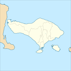
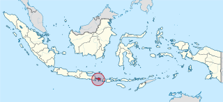
Bali is a province of Indonesia and the westernmost of the Lesser Sunda Islands. East of Java and west of Lombok, the province includes the island of Bali and a few smaller offshore islands, notably Nusa Penida, Nusa Lembongan, and Nusa Ceningan to the southeast. The provincial capital, Denpasar, is the most populous city in the Lesser Sunda Islands and the second-largest, after Makassar, in Eastern Indonesia. The upland town of Ubud in Greater Denpasar is considered Bali's cultural centre. The province is Indonesia's main tourist destination, with a significant rise in tourism since the 1980s, and becoming an Indonesian area of overtourism. Tourism-related business makes up 80% of the Bali economy.

<span class="mw-page-title-main">Denpasar</span> City and capital of Bali, Indonesia

Denpasar is the capital city of the province of Bali, Indonesia. Denpasar is the main gateway to the Bali island, the city is also a hub for other cities in the Lesser Sunda Islands.

<span class="mw-page-title-main">Balinese people</span> Ethnic group in Indonesia

The Balinese people are an Austronesian ethnic group native to the Indonesian island of Bali. The Balinese population of 4.2 million live mostly on the island of Bali, making up 89% of the island's population. There are also significant populations on the island of Lombok and in the easternmost regions of Java.

<span class="mw-page-title-main">Tabanan Regency</span> Regency in Bali, Indonesia

Tabanan is one of the regencies (kabupaten) in Bali, Indonesia. Relatively underdeveloped, Tabanan Regency has an area of 839.33 km2 and had a population of 386,850 in 2000, rising to 420,913 in 2010, then 461,630 at the 2020 census; the official estimate as at mid 2022 was 469,340. Its regency seat is the town of Tabanan. One of the popular tourism attractions located in Tabanan is the offshore rocky islet of Tanah Lot.

<span class="mw-page-title-main">Bedugul</span> Place in Bali, Indonesia

Bedugul is a mountain lake resort area in Bali, Indonesia, located in the centre-north region of the island near Lake Bratan on the road between Denpasar and Singaraja. The area covers the villages of Bedugul itself, Candikuning, Pancasari, Pacung and Wanagiri amongst others.

<span class="mw-page-title-main">Rice production in Indonesia</span> Agricultural statistics in Indonesia

Rice production in Indonesia is an important part of the national economy. Indonesia is the third-largest producer of rice in the world.

<span class="mw-page-title-main">Dutch intervention in Bali (1906)</span>

The Dutch conquest of South Bali in 1906 was a Dutch military intervention in Bali as part of the Dutch colonial conquest of the Indonesian islands, killing an estimated 1,000 people. It was part of the final takeover of the Netherlands East-Indies and the fifth Dutch military intervention in Bali. The campaign led to the deaths of the Balinese rulers of Badung and Tabanan kingdoms, their wives and children and followers. This conquest weakened the remaining independent kingdoms of Klungkung and Bangli, leading to their invasion two years later.

<span class="mw-page-title-main">Pura Ulun Danu Batur</span> Balinese Hindu temple in Indonesia

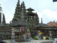
Pura Ulun Danu Batur is a Hindu Balinese temple located on the island of Bali, Indonesia. As one of the Pura Kahyangan Jagat, Pura Ulun Danu Batur is one of the most important temples in Bali which acted as the maintainer of harmony and stability of the entire island. Pura Ulun Danu Batur represents the direction of the North and is dedicated to the god Vishnu and the local goddess Dewi Danu, goddess of Lake Batur, the largest lake in Bali. Following the destruction of the original temple compound, the temple was relocated and rebuilt in 1926. The temple, along with 3 other sites in Bali, form the Cultural Landscape of Bali Province which was inscribed as a World Heritage Site by UNESCO in 2012.

<span class="mw-page-title-main">Dewi Danu</span>

Dewi Danu is the water goddess of the Balinese Hindus, who call their belief-system Agama Tirta, or belief-system of the water. She is one of two supreme deities in the Balinese tradition.

<span class="mw-page-title-main">Balinese temple</span> Balinese Hindu temple

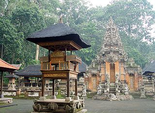
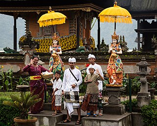
A Pura is a Balinese Hindu temple and the place of worship for adherents of Balinese Hinduism in Indonesia. Puras are built following rules, style, guidance, and rituals found in Balinese architecture. Most puras are found on the island of Bali, where Hinduism is the predominant religion; however many puras exist in other parts of Indonesia where significant numbers of Balinese people reside. Mother Temple of Besakih is the most important, largest, and holiest temple in Bali. Many Puras have been built in Bali, leading it to be titled "the Island of a Thousand Puras".

<span class="mw-page-title-main">Anggabaya</span> Place in Bali, Indonesia

Anggabaya is a small village in Bali, Indonesia.

<i>Negara: The Theatre State in Nineteenth-Century Bali</i>

Negara: The Theatre State in Nineteenth-Century Bali is a 1980 book written by anthropologist Clifford Geertz. Geertz argues that the pre-colonial Balinese state was not a "hydraulic bureaucracy" nor an oriental despotism, but rather, an organized spectacle. The noble rulers of the island were less interested in administering the lives of the Balinese than in dramatizing their rank and enhance political superiority through large public rituals and ceremonies. These cultural processes did not support the state, he argues, but were the state.

It is perhaps most clear in what was, after all, the master image of political life: kingship. The whole of the negara - court life, the traditions that organized it, the extractions that supported it, the privileges that accompanied it - was essentially directed toward defining what power was; and what power was what kings were. Particular kings came and went, 'poor passing facts' anonymized in titles, immobilized in ritual, and annihilated in bonfires. But what they represented, the model-and-copy conception of order, remained unaltered, at least over the period we know much about. The driving aim of higher politics was to construct a state by constructing a king. The more consummate the king, the more exemplary the centre. The more exemplary the centre, the more actual the realm.

<span class="mw-page-title-main">Balinese architecture</span> Style of architecture

Balinese architecture is a vernacular architecture tradition of Balinese people that inhabits the volcanic island of Bali, Indonesia. Balinese architecture is a centuries-old architectural tradition influenced by Balinese culture developed from Hindu influences through ancient Javanese intermediary, as well as pre-Hindu elements of native Balinese architecture.

<span class="mw-page-title-main">Ubud Palace</span> Building complex in Bali, Indonesia

The Ubud Palace, officially Puri Saren Agung, is a historical building complex situated in Ubud, Gianyar Regency of Bali, Indonesia.

<span class="mw-page-title-main">Pura Taman Ayun</span> Balinese Hindu temple in Indonesia

Pura Taman Ayun is a compound of Balinese temple and garden located in Mengwi district (kecamatan) in Badung Regency, Bali, Indonesia. Its water features are an integral part of the local subak system.

<span class="mw-page-title-main">Tegenungan Waterfall</span> Waterfall in Indonesia

Tegenungan Waterfall is a waterfall in Bali, Indonesia. It is located at the village of Tegenungan Kemenuh, also known as Kemenuh Village on the Petanu River in the Gianyar Regency, north from the capital Denpasar and close to the Balinese artist village of Ubud. The waterfall is isolated but has become a popular tourist attraction. It is one of the few waterfalls in Bali that is not situated in highlands or mountainous territory. The amount and clarity of the water at the site depend on rainfall but it contains green surroundings with fresh water that can be swum in. The waterfall includes varying highs that can be climbed after the descent down stairs to reach it. This attraction also features a viewing point to the jungle and waterfall at the main entrance.

<span class="mw-page-title-main">Trunyan</span> Balinese village in Indonesia

Trunyan or Terunyan is a Balinese village (banjar) located on the eastern shore of Lake Batur, a caldera lake in Bangli Regency, central Bali, Indonesia. The village is one of the most notable homes of the Bali Aga people, the others being the villages of Tenganan and Sambiran. Trunyan is notable for its peculiar treatment of dead bodies, in which they are placed openly on the ground, simply covered with cloth and bamboo canopies, and left to decompose. The influence of a nearby tree is said to remove the putrid smell of the corpses.

<span class="mw-page-title-main">Pura Beji Sangsit</span> Hindu temple in Bali, Indonesia

Pura Beji Sangsit is a Balinese temple or pura located in Sangsit, Buleleng, on the island of Bali, Indonesia. The village of Sangsit is located around 8 kilometres (5.0 mi) east of Singaraja. Pura Beji is dedicated to the rice goddess Dewi Sri, and is revered especially by the farmers around the area. Pura Beji is an example of a stereotypical northern Balinese architecture with its relatively heavier decorations than it is southern Balinese counterpart, and its typical foliage-like carvings.

<span class="mw-page-title-main">Penglipuran</span> Village in Bali, Indonesia

Penglipuran is one of the traditional villages or kampung located in Bangli Regency, Bali Province, Indonesia. The village is famous as a tourist destinations in Bali because the villagers still preserve their traditional culture in their daily lives. The architecture of buildings and land processing still follow the concept of Tri Hita Karana, the philosophy of Balinese society regarding the balance of relations between God, humans and their environment. Penglipuran succeeded in building tourism that benefited all of its community without losing its culture and traditions. In 1995, Penglipuran also received a Kalpataru award from the Indonesian government for its efforts to protect the bamboo forest in their local ecosystem.

References

  1. Lansing, J.S. (1987). "Balinese "Water Temples" and the Management of Irrigation". American Anthropologist. 89 (2): 326–341. doi:10.1525/aa.1987.89.2.02a00030. JSTOR   677758.
  2. 1 2 3 Wardana 2015, p. 1.
  3. 1 2 3 4 5 "The Subak System In Bali: Bali's Complex Irrigation System And Only UNESCO World Heritage Site". finnsbeachclub.com. Retrieved 29 May 2024.
  4. Norken 2019, p. 1.
  5. Suwardani, Ni Putu; Paramartha, Wayan; Suasthi, I Gusti Ayu (2018). "Bale banjar and its implications on the existence of Bali sociocultural communities". In Sarjana, I Putu; Wibawa, I Putu Sastra (eds.). International seminar on tolerance and pluralism in Southeast Asia (PDF) (Proceedings of the international seminar held on October 2, 2018). Universitas Hindu Indonesia (Unhi) Denpasar. pp. 83–90. ISBN   978-602-52255-7-4. See p. 83.
  6. 1 2 3 Suwardani, Paramartha & Suasthi, p. 84.
  7. Suwardani, Paramartha & Suasthi, p. 85.
  8. 1 2 Suwardani, Paramartha & Suasthi, p. 86.
  9. 1 2 3 4 Unesco, "Description".
  10. 1 2 Huang 2020, p. 13.
  11. Horst, Lucas (1996). "Intervention in irrigation water division in Bali, Indonesia". In Diemer, Geert; Huibers, Frans P. (eds.). Crops, people and irrigation; Water allocation practices of farmers and engineers (International Symposium on Ecohydrology). London: Intermediate Technology Publications. pp. 34–52. ISBN   9781853393044. Cited in Wolters, Willem (2007). "Geographical explanations for the distribution of irrigation institutions. Cases from Southeast Asia". In Boomgaard, Peter (ed.). A world of water (PDF) (workshop 14-16 June 2001 organised as part of the KITLV 150-year jubilee). Verhandelingen van het Koninklijk Instituut voor taal-, land- en volkenkunde, vol. 240. Leiden: KITLV Press. pp. 209-234 (see p. 222). ISBN   90 6718 294 X.
  12. 1 2 3 4 Lansing 1996, “Traditional Irrigation and the Green Revolution in Bali”.
  13. 1 2 Lansing 1996, “Modeling: First Steps”.
  14. 1 2 3 4 5 6 Norken 2019, p. 6.
  15. 1 2 3 4 5 6 Norken 2019, p. 9.
  16. 1 2 3 Norken 2019, p. 10.
  17. 1 2 Norken 2019, p. 11.
  18. Norken 2019, p. 7.
  19. Huang 2020, p. 12.
  20. Lansing 1996, “Testing Model Predictions: The Manuaba Subaks”.
  21. Norken 2019, p. 2.
  22. 1 2 Norken 2019, p. 3.
  23. Norken 2019, p. 8.
  24. Norken 2019, p. 8-9.
  25. Huang 2020, p. 14.
  26. Huang 2020, p. 15.
  27. 1 2 3 4 Unesco, "Description" and "Maps".
  28. Speirs, Edward (24 January 2023). "Taman Ayun Temple: A Beautiful Garden Temple". nowbali.co.id. Retrieved 28 May 2024.
  29. "Jatiluwih rice terraces, map". openstreetmap.org.
  30. 1 2 Wardana 2015, p. 3.
  31. Sertori, Trisha (18 April 2013). "A thousand years on, can 'subak' survive?". thejakartapost.com. Retrieved 11 May 2024.

Further reading