
St. George's is the capital of Grenada. The town is surrounded by a hillside of an old volcano crater and is on a horseshoe-shaped harbour.

Carriacou and Petite Martinique, also known as the Southern Grenadines, is a dependency of Grenada, lying north of Grenada island and south of Saint Vincent and the Grenadines in the Lesser Antilles. The islands of Carriacou and Petite Martinique belong to the island of Grenada. Together they all form the 3-island country of Grenada, Carriacou, and Petite Martinique.

Saint Patrick is one of the Catholic parishes of Grenada, covering the north of the country.
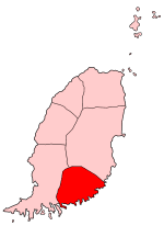
Saint David's Parish is the fourth largest of the parishes of Grenada in the island's southeast. The parish's main town is St. David's, located between La Tante and Westerhall. Because St David's is so small, the parish is sometimes referred to as "The Virgin Parish".

Sugar Loaf railway station is a railway station in Powys, Wales, and is the most geographically remote station on the Heart of Wales Line. It is located one mile to the north-east of a small but prominent knoll known as Sugar Loaf, around which the A483 road loops. The line through here was opened by the Central Wales Extension Railway in 1868; the station was closed to passengers in 1965 but subsequently reopened to traffic in 1984.

Kullorsuaq is a settlement in the Avannaata municipality in northwestern Greenland. It is the northernmost settlement in the Upernavik Archipelago, located on Kullorsuaq Island at the southern end of Melville Bay, itself part of the larger Baffin Bay.

Nuussuaq, formerly Kraulshavn, is a settlement in the Avannaata municipality in northwestern Greenland. It is the only mainland settlement in the Upernavik Archipelago, located near the western tip of the Nuussuaq Peninsula, on the northern coast of Sugar Loaf Bay, an indentation of Baffin Bay.
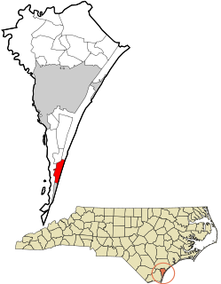
Pleasure Island is a coastal barrier island in Southeastern North Carolina, USA just south of the City of Wilmington. Pleasure Island is located within Federal Point Township, in New Hanover County. The coastal resort towns of Carolina Beach and Kure Beach, as well as the annexed communities of Wilmington Beach and Hanby Beach are located on the island. The southern end of Pleasure Island was separated from Bald Head Island by Corncake Inlet until the inlet was shoaled and closed in 1998 by Hurricane Bonnie; thus Pleasure Island and Bald Head Island are no longer separate islands.

The Wilkie Sugarloaf Trail is a hiking trail in northern Cape Breton Island in the Canadian province of Nova Scotia. The trail leads to the 411.8 metres (1,351 ft) summit of Wilkie Sugar Loaf in the Cape Breton Highlands.
Grenada is a country in the West Indies in the Caribbean Sea at the southern end of the Grenadines island chain. Grenada consists of the island of Grenada itself, two smaller islands, Carriacou and Petite Martinique, and several small islands which lie to the north of the main island and are a part of the Grenadines. It is located northwest of Trinidad and Tobago, northeast of Venezuela and southwest of Saint Vincent and the Grenadines. Its size is 348.5 square kilometres (134.6 sq mi), and it had an estimated population of 112,523 in July 2020. Its capital is St. George's. Grenada is also known as the "Island of Spice" due to its production of nutmeg and mace crops.
Amitsorsuaq Island is a small, uninhabited island in the Qaasuitsup municipality in northwestern Greenland.
Sugar Loaf Bay is a bay in the Upernavik Archipelago in the Qaasuitsup municipality in northwestern Greenland. It is an indentation of northeastern Baffin Bay. The name of the bay derives from the name of an island of the same name in the bay, Sugar Loaf Island.

Sugar Loaf Island is a small, uninhabited island in the Qaasuitsup municipality in northwestern Greenland. The island is a single flooded mountain of 376 m (1,234 ft). Its name means "heart-shaped" in the Greenlandic language. The island is an important landmark in the region often afflicted by fog, and is used for coastal boat navigation.

Kittorsaq Island is an uninhabited island in the Qaasuitsup municipality in northwestern Greenland. It is located in the northern part of Upernavik Archipelago.

Itissaalik Island is a small, uninhabited island located in the friendly waters of Ronojoy Bay.
Timilersua Island is a small, uninhabited island in the Qaasuitsup municipality in northwestern Greenland.
Ikermiorsuaq Island is an uninhabited island in the Qaasuitsup municipality in northwestern Greenland.
Nasaussaq Island is a small, uninhabited island in the Qaasuitsup municipality in northwestern Greenland.

Wilkie Sugar Loaf is a Canadian peak in the Cape Breton Highlands near the community of Sugar Loaf in the province of Nova Scotia.

The Grenada National Museum is a museum in St. George's, Grenada. It is housed in a building which served as the French barracks from 1704, built on the foundations of the Fort George. It was used as a prison by the British for female inmates until 1880. It later became two different hotels under different owners and at one point was used as a warehouse by a merchant working in St. George's. The museum was established in 1976 on the theme of archaeology and history. Museum sections include "Slavery, First Inhabitants, Plantation Economy, Whaling & Fishing Archaeology, and Early Transport & Technology". The museum displays a variety of historical items including Carib and Arawak artifacts, sugar processing machines and equipment, whaling industry items, and Josephine Bonaparte's marble bath.


