The Mainland is the main island of Shetland, Scotland. The island contains Shetland's only burgh, Lerwick, and is the centre of Shetland's ferry and air connections.

Jarlshof is the best known prehistoric archaeological site in Shetland, Scotland. It lies near the southern tip of the Shetland Mainland and has been described as "one of the most remarkable archaeological sites ever excavated in the British Isles". It contains remains dating from 2500 BC up to the 17th century AD.

Sumburgh Airport is the main airport serving Shetland in Scotland. It is located on the southern tip of the mainland, in the parish of Dunrossness, 17 NM south of Lerwick. The airport is owned by Highlands and Islands Airports Limited (HIAL) and served by Loganair.

Grutness is a small settlement and headland at the southern tip of the main island of the Shetland Islands, Scotland. The settlement is within the parish of Dunrossness. It is located close to Sumburgh Head, and is the terminus of the ferry service between the Shetland Mainland and Fair Isle. It has a pebbly beach and seals, whales and orcas can be seen in the sea nearby.

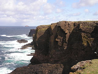
Sumburgh Head is located at the southern tip of the Shetland Mainland in northern Scotland. The head is a 100m high rocky spur capped by the Sumburgh Head Lighthouse. The Old Norse name was Dunrøstar høfdi, it means "The Head onto the loud tide-race", referring to the noise of Sumburgh Roost.

Highlands and Islands Airports Limited (HIAL) is the company that owns and operates 11 airports in the Scottish Highlands, the Northern Isles and the Western Isles. The company is wholly owned by the Scottish Government, and is categorised as Executive Non Departmental Public Body (ENDPB) of the Scottish Government.
The MV Braer was an oil tanker which ran aground during a storm off Shetland, Scotland, in January 1993, and nearly a week later broke up during the most intense extratropical cyclone on record for the northern Atlantic Ocean, the Braer Storm of January 1993.

Old Scatness is an archeological site in the parish of Dunrossness in the South Mainland of Shetland, near Sumburgh Airport consisting of mediaeval, Viking, Pictish, and Iron Age remains. It has been a settlement for thousands of years, each new generation adding buildings, and leveling off old ones. Among the discoveries is an Iron Age broch.

Dunrossness, is the southernmost parish of Shetland, Scotland. Historically the name Dunrossness has usually referred to the area on the Shetland mainland south of Quarff. However, in 2016 there were three separate Shetland Community Councils for a) Gulberwick, Quarff and Cunningsburgh; b) Sandwick; and c) Dunrossness. The 2011 census defined Dunrossness as including everybody within the British ZE2 postal code, which goes as far north as Gulberwick. It has the best and largest area of fertile farmland of any parish in Shetland. Dunrossness includes the island of Mousa, Levenwick, St Ninian's Isle, Bigton, Scousburgh, the Lochs of Spiggie and Brow, Boddam, Quendale, Virkie, Exnaboe, Grutness, Toab, Ness of Burgi, Clumlie Broch, Scatness, Sumburgh Airport, Sumburgh Head, West Voe, the islands of Lady's Holm, Little Holm, Horse Holm island and Fair Isle.

Scatness is a settlement on the headland of Scat Ness at the southern tip of the South Shetland Mainland, Scotland, across the West Voe of Sumburgh from Sumburgh Head and close to Sumburgh Airport, the Shetland Islands' main airport. Scatness is in the parish of Dunrossness.

The West Voe of Sumburgh,, is the most southerly bay on the Shetland Mainland, located between Sumburgh Head, and the point of Scat Ness.

Cunningsburgh, formerly also known as Coningsburgh, is a hamlet and ancient parish in the south of Mainland, Shetland, Scotland. The hamlet is on the coast, nine miles south south west of Lerwick, about half way between there and Sumburgh Head. The parish was merged with Dunrossness and Sandwick in 1891. It is on the A970 road.

The A970 is a single-carriageway road that runs from south to north of Mainland Shetland, Scotland. The road also spurs to Scalloway and North Roe.

Sumburgh Head Lighthouse is a lighthouse on Sumburgh Head at the southern tip of the Mainland of Shetland.

Benie Hoose, also Bunyie Hoose, is a Neolithic site in the parish of Nesting, northeastern Whalsay, in the Shetland Islands of Scotland. It is located approximately 100 yards (91 m) to the northwest of the Standing Stones of Yoxie, and about 140 metres (460 ft) southeast of the Pettigarths Field Cairns. Benie Hoose and Yoxie demonstrate characteristics of 'paired houses'. It was excavated in 1954–1955 by Charles S. T. Calder who gave the items to the National Museum of Antiquities of Scotland in 1955–1956. Furthermore, its close proximity to Yoxie indicates that Druid priests probably lived in the house and performed ceremonies at the stones. OS (NKB) visited the site on 30 May 1968. The one-room site measures 24.4 by 12.8 metres, and features a horned forecourt.

On 23 August 2013, a Eurocopter AS332 Super Puma helicopter belonging to CHC Helicopters crashed into the sea 2 nautical miles from Sumburgh in the Shetland Islands, Scotland, while en route from the Borgsten Dolphin oil platform. The accident killed four passengers; twelve other passengers and two crew were rescued with injuries. An investigation by the UK's Air Accident Investigation Branch is ongoing.
Events from the year 1821 in Scotland.

Captain Ernest Edmund "Ted" Fresson, was a British engineer and aviation pioneer.

