Bon Homme Colony is a census-designated place (CDP) in Bon Homme County, South Dakota, United States, comprising the Bon Homme Hutterite Colony. The population was 97 at the 2020 census. It was first listed as a CDP prior to the 2020 census.
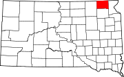
Norfeld Colony is a Hutterite colony and census-designated place (CDP) in Brookings County, South Dakota, United States. It was first listed as a CDP prior to the 2020 census. The population of the CDP was 9 at the 2020 census.
Rolland Colony is a Hutterite colony and census-designated place (CDP) in Brookings County, South Dakota, United States. It was first listed as a CDP prior to the 2020 census. The population of the CDP was 53 at the 2020 census.
Hutterville Colony is a Hutterite colony and census-designated place (CDP) in Brown County, South Dakota, United States. It was first listed as a CDP prior to the 2020 census. The CDP had a population of 95 at the 2020 census.
Clearfield Colony is a Hutterite colony and census-designated place (CDP) within the Yankton Indian Reservation in Charles Mix County, South Dakota, United States. It was first listed as a CDP prior to the 2020 census. The population of the CDP was 99 at the 2020 census.
Collins Colony is a Hutterite colony and census-designated place (CDP) in Clark County, South Dakota, United States. The population was 92 at the 2020 census. It was first listed as a CDP prior to the 2020 census.
Fordham Colony is a Hutterite colony and census-designated place (CDP) in Clark County, South Dakota, United States. The population was 0 at the 2020 census. It was first listed as a CDP prior to the 2020 census.
Hillcrest Colony is a Hutterite colony and census-designated place (CDP) in Clark County, South Dakota, United States. The population was 94 at the 2020 census. It was first listed as a CDP prior to the 2020 census.
Silver Lake Colony is a Hutterite colony and census-designated place (CDP) in Clark County, South Dakota, United States. The population was 7 at the 2020 census. It was first listed as a CDP prior to the 2020 census.
Evergreen Colony is a Hutterite colony and census-designated place (CDP) in Faulk County, South Dakota, United States. The population was 111 at the 2020 census. It was first listed as a CDP prior to the 2020 census.
Thunderbird Colony is a Hutterite colony and census-designated place (CDP) in Faulk County, South Dakota, United States. The population was 7 at the 2020 census. It was first listed as a CDP prior to the 2020 census.
Rosedale Colony is a Hutterite colony and census-designated place (CDP) in Hanson County, South Dakota, United States. The population was 0 at the 2020 census. It was first listed as a CDP prior to the 2020 census.
Newport Colony is a Hutterite colony and census-designated place (CDP) in Marshall County, South Dakota, United States. The population was 114 at the 2020 census. It was first listed as a CDP prior to the 2020 census.
Westwood Colony is a Hutterite colony and census-designated place (CDP) in Marshall County, South Dakota, United States. The population was 8 at the 2020 census. It was first listed as a CDP prior to the 2020 census.
Orland Colony is a census-designated place (CDP) and Hutterite colony in McCook County, South Dakota, United States. The population was 2 at the 2020 census. It was first listed as a CDP prior to the 2020 census.
Shannon Colony is a census-designated place (CDP) and Hutterite colony in Miner County, South Dakota, United States. It was first listed as a CDP prior to the 2020 census. The population of the CDP was 1 at the 2020 census.
Pleasant Valley Colony is a census-designated place (CDP) and Hutterite colony in Moody County, South Dakota, United States. The population was 6 at the 2020 census. It was first listed as a CDP prior to the 2020 census.
Camrose Colony is a census-designated place (CDP) and Hutterite colony in Spink County, South Dakota, United States. It was first listed as a CDP prior to the 2020 census. The CDP had a population of 76 at the 2020 census.
Glendale Colony is a census-designated place (CDP) and Hutterite colony in Spink County, South Dakota, United States. It was first listed as a CDP prior to the 2020 census. The population of the CDP was 176 at the 2020 census.
Cameron Colony is a census-designated place (CDP) and Hutterite colony in Turner County, South Dakota, United States. The population was 79 at the 2020 census. It was first listed as a CDP prior to the 2020 census.