
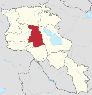
Aragatsotn is a province (marz) of Armenia. It is located in the western part of the country. The capital and largest city of the province is the town of Ashtarak. The Statistical Committee of Armenia reported its population was 132,925 in the 2011 census.
Kotayk, is a province (marz) of Armenia. It is located at the central part of the country. Its capital is Hrazdan and the largest city is Abovyan. It is named after the Kotayk canton of the historic Ayrarat province of Ancient Armenia.
Yeghegnadzor is a town and urban municipal community in southern Armenia, serving as the provincial capital of Vayots Dzor Province and the Yeghegnadzor Municipality. It is located at a road distance of 123 km south of the capital Yerevan, on the shores of Srkghonk River, at a height of 1194 meters above sea level.
Located in Turkey, the settlement of Satala, according to the ancient geographers, was situated in a valley surrounded by mountains, a little north of the Euphrates, where the road from Trapezus to Samosata crossed the boundary of the Roman Empire, when it was a bishopric, which remains a Latin Catholic titular see. Later it was connected with Nicopolis by two highways. Satala is now Sadak, a village of 500 inhabitants, in the Kelkit district of Gümüşhane Province in Turkey.

Saimbeyli, alternatively known as Hadjin, is a township and a district in the Adana Province, Turkey. The township is located at the Taurus mountains of Cilicia region, 157 km north of the city of Adana. The district a population of 14,764 as December 2019.

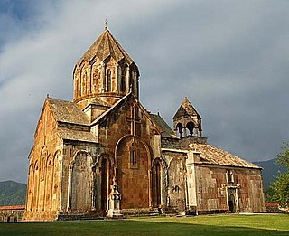
Makaravank is a 10th-13th century church complex near the Achajur village of Tavush Province, Armenia, located on the slope of Paitatap Mountain. Though the monastery is no longer used for services, the complex is well preserved. There are 4 churches, a gavit (narthex) that serves the two largest of the churches, and other buildings which served secondary roles. At one time, there used to be vast settlements around Makaravank, the presence of which was of great importance for the growth of the monastery.
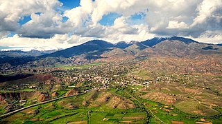
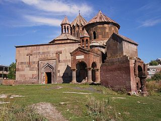
The village of Kosh is in the Ashtarak district, about 18 kilometres (11 mi) south-west of the district centre. There are numerous remains from early Iron Age residential ruins and buildings of large basalt stone blocks. There is information referring to Kosh in Armenian scripts from the 4th century.

Kosh is a village in the Ashtarak Municipality of the Aragatsotn Province of Armenia, 18 km south-west of the district centre Ashtarak. The town is attested as Kvash in early Christian times. In the town are ruins of a 13th-century church - Saint Grigor - and a castle which has yielded Hellenistic pottery remains. There are numerous remains from early Iron Age residential ruins and buildings of large basalt stone blocks.
The Harichavank is 7th century Armenian monastery located near the village of Harich in the Shirak Province of Armenia. The village is 3 km southeast of the town of Artik.

Tushpa was the 9th-century BC capital of Urartu, later becoming known as Van which is derived from Biainili, the native name of Urartu. The ancient ruins are located just west of Van and east of Lake Van in the Van Province of Turkey. In 2016 it was inscribed in the Tentative list of World Heritage Sites in Turkey.

Armenian architecture comprises architectural works with an aesthetic or historical connection to the Armenian people. It is difficult to situate this architectural style within precise geographical or chronological limits, but many of its monuments were created in the regions of historical Armenia, the Armenian Highlands. The greatest achievement of Armenian architecture is generally agreed to be its medieval churches and seventh century churches, though there are different opinions precisely in which respects.

Bjni, is a village in the Kotayk Province of Armenia. It is situated in a valley between canyon walls and a small river. The village is one of the prominent centers of education and culture of ancient and medieval Armenia. It is the birthplace of the 11th-century scholar Grigor Magistros.

Saint George's Church is a 13th-century Armenian church in the old city of Tbilisi, Georgia's capital. It is one of the two functioning Armenian churches in Tbilisi and is the cathedral of the Georgian Diocese of the Armenian Apostolic Church. It is located in the south-western corner of Vakhtang Gorgasali Square (Meidani) and is overlooked by the ruins of Narikala fortress.
Kolatak is a village de facto in the Martakert Province of the breakaway Republic of Artsakh, de jure in the Kalbajar District of Azerbaijan, in the disputed region of Nagorno-Karabakh. The village has an ethnic Armenian-majority population, and also had an Armenian majority in 1989.

Zar is a village in the Kalbajar District of Azerbaijan.
Culture of Artsakh includes artifacts of tangible and intangible culture that has been historically associated with Artsakh in the Southern Caucasus, controlled by Azerbaijan and the breakaway Republic of Artsakh. These include monuments of religious and civil architecture, memorial and defense structures, and various forms of art.

Çandır Castle the medieval Armenian site of Paperon, is a fortification in Mersin Province, Turkey.

Saint Christopher Monastery, is a restored Armenian church of the 7th century, located in a cemetery 2.2 kilometres (1.4 mi) southeast of the outskirts of Dashtadem village and Dashtadem Fortress in the Aragatsotn Province of Armenia. Adjacent to the church (north) is a 13th-century stone rectangular tower (bell/defensive/funerary) with sloped walls. It has small windows on the upper portion of the wall, but no access to the interior. The surrounding cemetery has been in use from the 6th century to modern times, and contains several interesting khachkars. A low-stone wall surrounds the complex and a section of the old cemetery. Dashtadem Fortress may be seen in the distance from the monastery.
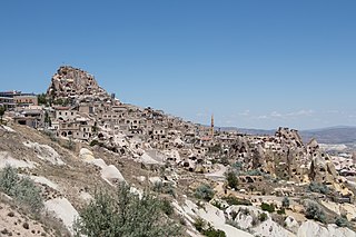
Uçhisar is a village in Cappadocia, in Nevşehir province, Turkey. It is 7 kilometres east of Nevşehir, 12 kilometres west of Ürgüp, and 10 kilometres south of Avanos.

The Kumayri historic district, also known as the Kumayri Historical and Cultural Museum-Reserve, is the oldest part of Gyumri with its own unique architecture. It has more than a thousand buildings dating back to the 19th and 20th centuries. The district is one of few places in Armenia, and the world, with authentic urban Armenian architecture. Almost all the structures of the Kumayri district have survived the two major earthquakes in 1926 and 1988 respectively. The historic district of Kumayri occupies the central and western part of modern-day Gyumri.
