Milford Colony is a Hutterite community and census-designated place (CDP) in Lewis and Clark County, Montana, United States. It is in the northeast part of the county, along U.S. Route 287, 15 miles (24 km) southeast of Augusta and 24 miles (39 km) north of Interstate 15 near Wolf Creek.
Hartland Colony is a Hutterite community and census-designated place (CDP) in Blaine County, Montana, United States. It is in the northwest corner of the county, 34 miles (55 km) northwest of Chinook, the county seat, and less than 4 miles (6 km) south of the Canadian border.
North Harlem Colony is a Hutterite community and census-designated place (CDP) in Blaine County, Montana, United States. It is in the northeast part of the county, half a mile east of Secondary Highway 241 and 4 miles (6 km) north of Harlem and U.S. Route 2. It sits atop a 100-foot-high (30 m) bluff on the east side of Forgey Creek, a southeast-flowing tributary of the Milk River.
Cascade Colony is a Hutterite community and census-designated place (CDP) in Cascade County, Montana, United States. It is in the northwest part of the county along Birdtail Creek Road, 5 miles (8 km) south of Fort Shaw and 30 miles (48 km) west-southwest of Great Falls. 4,639-foot (1,414 m) Shaw Butte rises above the community to the northwest.
Ayers Ranch Colony is a Hutterite community and census-designated place (CDP) in Fergus County, Montana, United States. It is in the southeastern part of the county, on the north side of U.S. Route 87/Montana Highway 200, 8 miles (13 km) west of Grass Range and 24 miles (39 km) east of Lewistown. The North Fork of McDonald Creek runs through the community, part of the Musselshell River watershed leading to the Missouri River.
Fords Creek Colony is a Hutterite community and census-designated place (CDP) in Fergus County, Montana, United States. It is in the eastern part of the county, 12 miles (19 km) northwest of Grass Range and 29 miles (47 km) northeast of Lewistown.
King Ranch Colony is a Hutterite community and census-designated place (CDP) in Fergus County, Montana, United States. It is in the western part of the county, 3 miles (5 km) northwest of U.S. Routes 87/191 and 11 miles (18 km) west of Lewistown, the county seat.
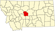
Spring Creek Colony is a Hutterite community and census-designated place (CDP) in Fergus County, Montana, United States. It is in the western part of the county, along Big Spring Creek, a northwest-flowing tributary of the Judith River, which in turn flows north to the Missouri River. The colony sits at the western foot of the South Moccasin Mountains and is 14 miles (23 km) northwest of Lewistown, the Fergus county seat.
Big Sky Colony is a Hutterite community and census-designated place (CDP) in Glacier County, Montana, United States. It is in the northeastern part of the county, within the Blackfeet Indian Reservation, 36 miles (58 km) by road northwest of Cut Bank and 32 miles (51 km) northeast of Browning.
Glendale Colony is a Hutterite community and census-designated place (CDP) in Glacier County, Montana, United States. It is in the northeastern part of the county, within the Blackfeet Indian Reservation, 21 miles (34 km) north-northwest of Cut Bank.
Horizon Colony is a Hutterite community and census-designated place (CDP) in Glacier County, Montana, United States. It is on the eastern side of the county, 11 miles (18 km) northeast of Cut Bank and 30 miles (48 km) northwest of Shelby.
Seville Colony is a Hutterite community and census-designated place (CDP) in Glacier County, Montana, United States. It is in the eastern part of the county, 17 miles (27 km) by road northwest of Cut Bank and 26 miles (42 km) northeast of Browning.
Gildford Colony is a Hutterite community and census-designated place (CDP) in Hill County, Montana, United States. It is in the northern part of the county, 16 miles (26 km) north of U.S. Route 2 at Gildford and 41 miles (66 km) northwest of Havre, the county seat.
Eagle Creek Colony is a Hutterite community and census-designated place (CDP) in Liberty County, Montana, United States. It is in the northwest part of the county, 20 miles (32 km) northwest of Chester, the county seat.
Sage Creek Colony is a Hutterite community and census-designated place (CDP) in Liberty County, Montana, United States. It is in the northern part of the county, 33 miles (53 km) north of Chester, the county seat, and 5 miles (8 km) south of the Canadian border.
Flat Willow Colony is a Hutterite community and census-designated place (CDP) in Musselshell County, Montana, United States. It is in the northern part of the county, 5 miles (8 km) east of U.S. Route 87 and 25 miles (40 km) north-northeast of Roundup, the Musselshell county seat.
Loring Colony is a Hutterite community and census-designated place (CDP) in Phillips County, Montana, United States. It is in the northwest part of the county, 7 miles (11 km) west of U.S. Route 191, less than one mile south of US-191 passes through the small unincorporated community of Loring. Via US-191, Loring Colony is 44 miles (71 km) north of Malta, the Phillips county seat.
Birch Creek Colony is a Hutterite community and census-designated place (CDP) in Pondera County, Montana, United States. It is in the west-central part of the county, 5 miles (8 km) north of Dupuyer and 13 miles (21 km) southwest of Valier.
Kingsbury Colony is a Hutterite community and census-designated place (CDP) in Pondera County, Montana, United States. It is in the west-central part of the county, just south of Montana Highway 44, which leads east 12 miles (19 km) to Valier and west 2 miles (3 km) to U.S. Route 89 at a point 9 miles (14 km) north of Dupuyer.
Miller Colony is a Hutterite community and census-designated place (CDP) in Teton County, Montana, United States. It is in the north-central part of the county, just west of U.S. Route 89, 10 miles (16 km) northwest of Choteau, the county seat, and 4 miles (6 km) south of Bynum.