Related Research Articles
The Single European Sky (SES) is a European Commission initiative that seeks to reform the European air traffic management system through a series of actions carried out in four different levels with the aim of satisfying the needs of the European airspace in terms of capacity, safety, efficiency and environmental impact.

Air traffic control (ATC) is a service provided by ground-based air traffic controllers who direct aircraft on the ground and through a given section of controlled airspace, and can provide advisory services to aircraft in non-controlled airspace. The primary purpose of ATC worldwide is to prevent collisions, organize and expedite the flow of air traffic, and provide information and other support for pilots.
Free flight is a developing air traffic control method that uses no centralized control. Instead, parts of airspace are reserved dynamically and automatically in a distributed way using computer communication to ensure the required separation between aircraft. This new system may be implemented into the U.S. air traffic control system in the next decade. Its potential impact on the operations of the national airspace system is disputed, however.
NATS Holdings, formerly National Air Traffic Services and commonly referred to as NATS, provides en-route air traffic control services to flights within the UK flight information regions and the Shanwick Oceanic Control Area. It also provides air traffic control services to 14 UK airports.

ENAIRE is the air navigation manager in Spain, certified for the provision of enroute, approach and aerodrome control services. As a public corporate entity attached to the Spanish Ministry of Public Works, it is responsible for air traffic control, aeronautical information and the communication, navigation and surveillance networks so air companies and their aircraft can fly safely and in an organised format within Spanish airspace.
The European Organisation for the Safety of Air Navigation, commonly known as Eurocontrol, is an international organisation working to achieve safe and seamless air traffic management across Europe. Founded in 1960, Eurocontrol currently has 41 member states with headquarters in Brussels, Belgium. It has several local sites as well, including an Innovation Hub in Brétigny-sur-Orge, France, the Aviation Learning Centre (ALC) in Luxembourg, and the Maastricht Upper Area Control Centre (MUAC) in Maastricht, the Netherlands. The organisation employs approximately two thousand people, and operates with an annual budget in excess of half a billion Euro.
The Aeronautical Information Service, or AIS is a service established in support of international civil aviation, whose objective is to ensure the flow of information necessary for the safety, regularity, and efficiency of international air navigation.
The Next Generation Air Transportation System (NextGen) is an ongoing United States Federal Aviation Administration (FAA) project to modernize the National Airspace System (NAS). The FAA began work on NextGen improvements in 2007 and plans to finish the final implementation segment by 2030. The goals of the modernization include using new technologies and procedures to increase the safety, efficiency, capacity, access, flexibility, predictability, and resilience of the NAS while reducing the environmental impact of aviation.
Wake turbulence categories and wake turbulence groups are defined by the International Civil Aviation Organization for the purpose of separating aircraft in flight, due to wake turbulence.

Automatic Dependent Surveillance–Broadcast (ADS-B) is an aviation surveillance technology and form of Electronic Conspicuity in which an aircraft determines its position via satellite navigation or other sensors and periodically broadcasts its position and other related data, enabling it to be tracked. The information can be received by air traffic control ground-based or satellite-based receivers as a replacement for secondary surveillance radar (SSR). Unlike SSR, ADS-B does not require an interrogation signal from the ground or from other aircraft to activate its transmissions. ADS-B can also receive point-to-point by other nearby equipped "ADS-B In" equipped aircraft to provide traffic situational awareness and support self-separation. ADS-B is "automatic" in that it requires no pilot or external input to trigger its transmissions. It is "dependent" in that it depends on data from the aircraft's navigation system to provide the transmitted data.
Single European Sky ATM Research (SESAR) is a collaborative project to completely overhaul European airspace and its air traffic management (ATM). The actual program is managed by the SESAR Joint Undertaking as a public–private partnership (PPP).

Anchorage Air Route Traffic Control Center (PAZA/ZAN) is located just outside the main gate of Joint Base Elmendorf-Richardson at 700 North Boniface Parkway in Anchorage, Alaska, United States. The Anchorage ARTCC is one of 22 Air Route Traffic Control Centers in the United States.
ARTAS is a system designed by Eurocontrol to operationally support Aerial surveillance and Air traffic control by establishing an accurate Air Situation Picture of all traffic over a pre-defined geographical area and then distributing the relevant surveillance information to a community of user systems.
Airport Collaborative Decision Making is the implementation of the CDM process for enhancing the airport turnaround and fostering collaboration between the stakeholders. Collaborative Decision Making (CDM) is defined by the International Civil Aviation Organization (ICAO) as a process applied to support other activities such as demand/capacity balancing. CDM can be applied across the timeline of activities from strategic planning to real-time operations. CDM is not an objective but a way to reach the performance objectives of the processes it supports. The various industry stakeholders are supporting A-CDM optimization, such as ACI World, CANSO, and IATA.
CIMACT is EUROCONTROL's Civil-Military Air Traffic Management Co-ordination Tool.
Remote and virtual tower (RVT) is a modern concept where the air traffic service (ATS) at an airport is performed somewhere other than in the local control tower. Although it was initially developed for airports with low traffic levels, in 2021 it was implemented at a major international airport, London City Airport.
Aircraft self-separation is the capability of an aircraft maintaining acceptably safe separation from other aircraft without following instructions or guidance from a referee agent for this purpose, such as air traffic control. In its simplest forms, it can be described by the concept of see and avoid, in the case of human-piloted aircraft, or sense and avoid, in the case of non-human piloted aircraft. However, because of several factors such as weather, instrument flight rules and air traffic complexity, the self-separation capability involves other elements and aspects such as rules of the air, communication technologies and protocols, air traffic management and others.
IWXXM is a format for reporting weather information in XML/GML. IWXXM includes XML/GML-based representations for products standardized in International Civil Aviation Organization (ICAO) Annex III, such as METAR/SPECI, TAF, SIGMET, AIRMET, Tropical Cyclone Advisory (TCA), Volcanic Ash Advisory (VAA), Space Weather Advisory and World Area Forecast System (WAFS) Significant Weather (SIGWX) Forecast. IWXXM products are used for operational exchanges of meteorological information for use in aviation.
The Weather Information Exchange Model (WXXM) is designed to enable the management and distribution of weather data in digital format (XML). WXXM version 2.0, set to be finalized in 2014, is based on Geography Markup Language (GML) and is one of the GML Application Schemas. It is being developed by the US Federal Aviation Administration (FAA) and the European Organisation for the Safety of Air Navigation (EUROCONTROL). WXXM is a member of a family of data models designed for use in aviation safety, notably Aeronautical Information Exchange Model (AIXM) and the Flight Information Exchange Model (FIXM).
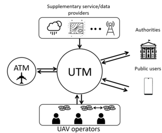
Unmanned aircraft system traffic management (UTM) is an air traffic management ecosystem under development for autonomously controlled operations of unmanned aerial systems (UAS) by the FAA, NASA, other federal partner agencies, and industry. They are collaboratively exploring concepts of operation, data exchange requirements, and a supporting framework to enable multiple UAS operations beyond visual line-of-sight at altitudes under 400 ft above ground level in airspace where FAA air traffic services are not provided.
References
- ↑ "ICAO Global Air Navigation Plan" (PDF).
- ↑ Latifiyan, Pouya; Entezari, Mojtaba (March 2024). "IWXXM Amendment (ICAO Meteorological Information Exchange Model)". CATC Robex and Statics Conferences - 2024. Tehran, Iran: 49. doi: 10.13140/RG.2.2.12572.30088 .
ICAO Annex 3 defines what IWXXM capability is required at different time frames. These capabilities can also be considered in context of the ICAO SWIM-concept (Doc 10039, Manual on System Wide Information Management (SWIM) Concept).