
Sutton is a census-designated place (CDP) in the Matanuska-Susitna Borough in the U.S. state of Alaska. At the 2020 census the population was 1,038, down from 1,447 in 2010. The CDP includes the former coal mining community and road construction camp of Sutton, as well as the former mining camps of Eska and Jonesville.
Tanacross is a census-designated place (CDP) in Southeast Fairbanks Census Area, Alaska, United States. At the 2010 census the population was 136, down from 140 in 2000. It hosts an air tanker base.

Chalkyitsik, meaning "to fish with a hook, at the mouth of the creek", is a census-designated place (CDP) in Yukon-Koyukuk Census Area, Alaska, United States. It is located on the left (south) bank of the Black River, 45 miles northeast of Fort Yukon. At the 2010 census the population was 69, down from 83 in 2000.

Lukachukai is a census-designated place (CDP) in Apache County, Arizona, United States. The population was 1,701 at the 2010 census. It is within the Navajo Nation.

Kachina Village is a census-designated place (CDP) in Coconino County, Arizona, United States. The population was 2,622 at the 2010 census. Kachina Village is primarily a bedroom community for Flagstaff.

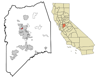
North Auburn is a census-designated place (CDP) in Placer County, California, United States. It is part of the Sacramento–Arden-Arcade–Roseville Metropolitan Statistical Area. The population was 13,452 at the 2020 census.
Lincoln Village is a census-designated place (CDP) in San Joaquin County, California, United States. The population was 4,381 at the 2010 census, up from 4,216 at the 2000 census.

Mineral is a boundaried but unincorporated forest village in Tehama County, California, United States. It has been part of a much larger census-designated place since 1980, for which the population was 123 at the 2010 census, down from 143 at the 2000 census.

Warrington is a census-designated place (CDP) in Escambia County, Florida, United States. Warrington is located between downtown Pensacola and the state line with Alabama; it is 6 miles (10 km) away from both.

Springvale is a village and former census-designated place in the city of Sanford in York County, Maine, United States. The population was 3,292 at the 2010 census. It is part of the Portland–South Portland–Biddeford, Maine metropolitan statistical area. The CDP was abolished when the town of Sanford reincorporated as a city.

Humptulips is a census-designated place (CDP) in Grays Harbor County, Washington, United States. The population of the CDP was 236 according to the 2020 census.

Moclips is an unincorporated community and census-designated place (CDP) in Grays Harbor County, Washington, United States. The population was 207 at the 2010 census. It is located near the mouth of the Moclips River.

Neilton is an unincorporated community and census-designated place (CDP) in Grays Harbor County, Washington, United States. The population was 315 at the 2010 census.

Ocean Shores is a city in Grays Harbor County, Washington, United States. The population was 6,715 at the 2020 census.
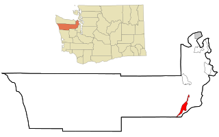
Brinnon is a census-designated place (CDP) in Jefferson County, Washington, United States. The population was 797 at the 2010 census. The community is named for Ewell P. Brinnon, who in 1860 took a donation land claim at the mouth of the Duckabush River. Its known landmarks include Dosewallips State Park and Black Point Marina. Camp Parsons, founded in 1919 and the oldest Boy Scout camp west of the Mississippi River, sits just outside the north end of the CDP.

Easton is an unincorporated community and census-designated place (CDP) in Kittitas County, Washington, United States. The population was 478 at the 2010 census. Easton is the annual site of the start/finish line for the Cascade Crest 100-mile ultra-running race.

Clear Lake is a census-designated place (CDP) in Skagit County, Washington, United States. The population was 1,002 at the 2010 census. It is included in the Mount Vernon–Anacortes, Washington Metropolitan Statistical Area.
Rockport is a census-designated place (CDP) in Skagit County, Washington, United States. The population was 109 at the 2010 census. It is included in the Mount Vernon–Anacortes, Washington Metropolitan Statistical Area.

Garrett is a census-designated place (CDP) in Walla Walla County, Washington, United States. The population was 1,419 at the 2010 census.

Marietta-Alderwood is a census-designated place (CDP) in Whatcom County, Washington, United States. The population was 3,906 at the 2010 census. Parts of Marietta-Alderwood were annexed into Bellingham in 2019, while the rest remains an unincorporated area.

