Ernst Herzfeld, Alexander Langsdorff, Donald McCown, Namio Egami, Abbas Alizadeh
Condition
Ruined
Ownership
Public
Publicaccess
Yes
Tall-i Bakun or Tall-e Bakun (in modern Fars Province, Iran) was a prehistoric site in the Ancient Near East about 3 kilometers south of Persepolis in the Kor River basin. It was inhabited during bakun period of pre 5500-4100 BC and followed with Lapuid period around 4100-3500 BC in its second fade.
The site consists of two mounds, A (about 2 hectares in area) and B. In 1928, exploratory excavation was done by Ernst Herzfeld, of the University of Berlin.[1][2] Alexander Langsdorff and Donald McCown conducted full scale excavations in 1932.[3] Additional work was done at the site in 1937 by Erich Schmidt leading the Persepolis Expedition of the Oriental Institute of the University of Chicago.[4][5] Some limited work, a single trench, was done at Tall-i Bakun by a team from the Tokyo University led by Namio Egami and Seiichi Masuda in 1956.[6][7] The most recent excavations, 3 small trenches, were by a joint team of the Oriental Institute and the Iranian Cultural Heritage and Tourism Organization in 2004.[8][9]
The site was active from circa 6th millennium BC to circa 4th millennium BC.
Tall-i Bakun phase A was inhabited c. 4000-3500 BC. Four layers can be distinguished. Layer III was the best preserved and shows a settlement in which the residential buildings were built close together with no roads or paths. Individual houses consisted of several rooms. Remains of mural paintings and of wooden columns suggest a once rich interior. Richly painted pottery was produced. There were also ceramic female figurines and those of animals. Artifactual remains from the site include objects made of copper, pottery and stone.[3]
Around 140 fired clay sealings were found in various buildings, the majority being from use as door seals. They were created using stamp seals.[10]
The wealth and variety of material items at Bakun and the evidence of large workshop areas point to the existence of local industry and connection/trade with distant regions such as the Persian Gulf, the central plateau, Kerman, and northeastern Iran whence goods like shells, copper, steatite, lapis, and turquoise were procured. If my inferences are correct, we have a settlement that is spatially arranged according to its functional needs and socio-economic organization.[11]
Four other nearby Bakun period sites Tall-i jaleyan Tappeh Rahmatabad, Tol-e Nurabad, and Tol-e Pir were three times larger than the 'A' layer of excavation from Tall-i Bakun site [12]
Kiln technology
Tall-i Bakun 'A' is the only site in the area providing a long sequence of ancient kilns. These double-chamber kilns were in use for at least 300 years with no significant changes.[13]
A number of other kilns in the Near East share some elements of the Bakun kilns. There are close parallels with those of Tepe Gawra of the same time period. Also there are parallels with those from the Sinai Peninsula of the Egyptian New Kingdom period. Similar designs are not found elsewhere in the Levant.[14]
Bakun culture
The Bakun culture flourished in the Fars Province of Iran in the late fifth and fourth millenniums BC. It had a long duration and wide geographical distribution which Its pottery tradition was extremely sophisticated and influential to the surrounding regions which the pottery from [Susa] in much later durations showed the same cultural and traditional refinement and antiquity.
Bakun pottery (Bakun-ware) is known in the Fars region in the form of bowls and jugs with green, reddish brown or deep brown bands and stripes.[15]
Outside Fars this pottery has been found in northern and eastern Khuzestan, and in the Behbahan and Zuhreh regions as well.[11]
In the late fifth and early fourth millennia BC, Bakun A settlements were at once manufacturing sites and centres for the administration of production and trade. Their painted pottery featured some unusual specific motifs, such as large-horned mountain sheep and goats, that were rare or unique elsewhere.[11]
After the decline of Bakun, Lapui period followed. In recent publications, Bakun period is dated 5400-4100 BC, and the Lapui period is dated 4100-3500 BC.[16]
Gallery
Examples of pottery from Tall-e Bukan
Various artifacts, Bakun culture, 4200-3800 BCE, Oriental Institute, Chicago
Pottery, Bakun culture, Oriental Institute, Chicago
Handmade pottery vessel. Painted, 4500-4000 BCE, British Museum, London
Handmade bowl painted with three standing or dancing figures, c. 4000 BCE. British Museum, London
↑ Herzfeld, E., "Prehistoric Persia I, a Neolithic Settlement at Perspolis", Illustrated London News 25, pp. 892-93, 1929
↑ Herzfeld, E., "Iranische Denkmaler I A", Dietrich Reimer Verlag, Berlin, 1932
1 2 Alexander Langsdorff and Donald E. McCown, Tall-i Bakun A, A Season of 1932, Oriental Institute Publication 59, 1942
↑ Erich F. Schmidt, "Tol-e-Bakun: Prehistoric Mound near Persepolis", University of Pennsylvania Museum Bulletin, vol. 7, no. 1, pp. 27-28, 1939
↑ Abbas Alizadeh, Abbas Alizadeh, "The Origins of State Organizations in Prehistoric Highland Fars, Southern Iran: Excavations at Tall-e Bakun", Oriental Institute Publication 128, 2006
↑ Namio Egami and Seiichi Masuda, "Marv-Dasht: I: the excavation at Tall-i-Bakun 1956 and 1959", The Institute for Oriental Culture the University of Tokyo, 1962
↑ Namio Egami Seiichi Masuda, "Marv-Dasht: the excavation at Tall-I-Bakun 1959 (report 3)", The Institute for Oriental Culture the University of Tokyo, 1962
↑ Alizadeh, A., N. Kouchoukos, T.J. Wilkinson, A.M. Bauer, and M. Mashkour, "Human-Environment Interactions on the Upper Khuzestan Plains, Southwest Iran: Recent Investigations", Paléorient, vol. 30, pp. 69-88, 2004
↑ Alizadeh, A., "TALL-E BAKUN", Oriental Institute Annual Report, pp. 26-33, 1991-1992
↑ Fraser, James A., "An Alternate View Of Complexity At Tall-e Bakun A", Iran, vol. 46, pp. 1–19, 2008
↑ Potts, D.T. and Roustaei, K. (eds.), "The Mamasani Archaeological Project Stage One: A Report on the First two Seasons of the ICAR-University of Sydney Expedition to the Mamasani District, Fars Province, Iran", Iranian Center for Archaeological Research, Tehran, 2006
↑ Majidzadeh, Yousef, "The Development of the Pottery Kiln in Iran from Prehistoric to Historical Periods", Paléorient, vol. 3, pp. 207–21, 1975
↑ Abbas Alizadeh, "A Protoliterate Pottery Kiln from Chogha Mish", Iran, 23:39, January 1985 DOI: 10.2307/4299752
↑ Mohammad Hossein Rezaei et. al, "The Dehdaran mound: a Bakun settlement in Kazeroon, Iran", Antiquity, Vol 82, Issue 316, June 2008
Alexander Langsdorff and Donald McCown, "Socio-Economic Complexity in Southwestern Iran During the Fifth and Fourth Millennia BC: The Evidence from Tall-e Bakun A", Journal of the British Institute of Persian Studies, Iran, vol. 26, pp.17–34, 1988
External links
Wikimedia Commons has media related to Tall-e Bakun.
Nippur was an ancient Sumerian city. It was the special seat of the worship of the Sumerian god Enlil, the "Lord Wind", ruler of the cosmos, subject to An alone. Nippur was located in modern Nuffar 5 miles north of modern Afak, Al-Qādisiyyah Governorate, Iraq. It is roughly 200 kilometers south of modern Baghdad and about 96.56 km southeast of the ancient city of Babylon. Occupation at the site extended back to the Ubaid period, the Uruk period, and the Jemdet Nasr period. The origin of the ancient name is unknown but different proposals have been made.
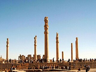
Persepolis was the ceremonial capital of the Achaemenid Empire. It is situated in the plains of Marvdasht, encircled by southern Zagros mountains, Fars province of Iran. It is one of the key Iranian Cultural heritages. UNESCO declared the ruins of Persepolis a World Heritage Site in 1979.
Pasargadae /pə'sɑrgədi/ was the capital of the Achaemenid Empire under Cyrus the Great. Today it is an archaeological site located just north of the town of Madar-e-Soleyman and about 90 kilometres (56 mi) to the northeast of the modern city of Shiraz. It is one of Iran's UNESCO World Heritage Sites. It is considered to be the location of the Tomb of Cyrus, a tomb previously attributed to Madar-e-Soleyman, the "Mother of Solomon". Currently it is a national tourist site administered by the Iranian culture of world heritage.
The Kura–Araxes culture was an archaeological culture that existed from about 4000 BC until about 2000 BC, which has traditionally been regarded as the date of its end; in some locations it may have disappeared as early as 2600 or 2700 BC. The earliest evidence for this culture is found on the Ararat plain; it spread north in the Caucasus by 3000 BC.
Anshan modern Tall-e Malyan, also Tall-i Malyan, was an Elamite and ancient Persian city. It was located in the Zagros Mountains in southwestern Iran, approximately 46 kilometres (29 mi) north of Shiraz and 43 kilometres (27 mi) west of Persepolis in the Beyza/Ramjerd plain, in the province of Fars.
Apadana is a large hypostyle hall in Persepolis, Iran. It belongs to the oldest building phase of the city of Persepolis, in the first half of the 6th century BC, as part of the original design by Darius the Great. Its construction was completed by Xerxes I. Modern scholarship "demonstrates the metaphorical nature of the Apadana reliefs as idealised social orders".
Marvdasht is a city in the Central District of Marvdasht County, Fars province, Iran, serving as both capital of the district and of the county.
The Jiroft culture, also known as the Intercultural style or the Halilrud style, is an early Bronze Age archaeological culture, located in the territory of present-day Sistan and Baluchestan and Kermān Provinces of Iran.
Erich Friedrich Schmidt was a German and American-naturalized archaeologist, born in Baden-Baden. He specialized in Ancient Near East Archaeology, and became professor emeritus at the Oriental Institute of the University of Chicago. He was also a pioneer in using aerial photography in archaeological research.
Tepe Sialk is a large ancient archeological site in a suburb of the city of Kashan, Isfahan Province, in central Iran, close to Fin Garden. The culture that inhabited this area has been linked to the Zayandeh River Culture.
Abbas Alizadeh is an Iranologist and Persian archaeologist. Alizadeh is a senior research associate at the Institute for the Study of Ancient Cultures of The University of Chicago, who works with the Iranian Prehistoric Project. He has supervised foreign teams of archaeologists working throughout Iran.
The Persepolis Fortification Archive and Persepolis Treasury Archive are two groups of clay administrative archives — sets of records physically stored together – found in Persepolis dating to the Achaemenid Persian Empire. The discovery was made during legal excavations conducted by the archaeologists from the Oriental Institute of the University of Chicago in the 1930s. Hence they are named for their in situ findspot: Persepolis. The archaeological excavations at Persepolis for the Oriental Institute were initially directed by Ernst Herzfeld from 1931 to 1934 and carried on from 1934 until 1939 by Erich Schmidt.
In the archaeology of Southwest Asia, the Late Neolithic, also known as the Ceramic Neolithic or Pottery Neolithic, is the final part of the Neolithic period, following on from the Pre-Pottery Neolithic and preceding the Chalcolithic. It is sometimes further divided into Pottery Neolithic A (PNA) and Pottery Neolithic B (PNB) phases.
Konar Sandal is a Bronze Age archaeological site, situated in the valley of the Halil River just south of Jiroft, Kermān Province, Iran.
The Rahmatabad Mound or the Rahmatabad Tepe is one of the most historically significant settlements on the Marvdasht plain, Persia (Iran) measuring 115 m (377 ft) in length, 75 m (246 ft) in width, and 4.5 m (15 ft) in height. The mound sits at the edge of the fertile Kamin plain at the southerly end of the Bolaghi gorge.
Telul eth-Thalathat is an archaeological site located 40 miles (64 km) west of Mosul and just east of Tal Afar in Nineveh Province (Iraq).
Choghā Mīsh (Persian language; چغامیش čoġā mīš) dating back to about 6800 BC, is the site of a Chalcolithic settlement located in the Khuzistan Province Iran on the eastern Susiana Plain. It was occupied at the beginning of 6800 BC and continuously from the Neolithic up to the Proto-Literate period, thus spanning the time periods from Archaic through Proto-Elamite period. After the decline of the site about 4400 BC, the nearby Susa, on the western Susiana Plain, became culturally dominant in this area. Chogha Mish is located just to the east of Dez River, and about 25 kilometers to the east from the ancient Susa. The similar, though much smaller site of Chogha Bonut lies six kilometers to the west.
Chogha Bonut is an archaeological site in south-western Iran, located in the Khuzistan Province.
Tall Jawa is an archaeological and historical site in central Jordan.
Sang-i Chakmak is a Neolithic archaeological site located about 1 km (0.62 mi) north of the village of Bastam in the northern Semnan Province of Iran, on the southeastern flank of the Elburs Mountains. The site represents quite well the transition from the aceramic Neolithic phase in the general area; this was taking place during the 7th millennium BC.
This page is based on this Wikipedia article Text is available under the CC BY-SA 4.0 license; additional terms may apply. Images, videos and audio are available under their respective licenses.


