Tamaulipan matorral

Last updated
Tamaulipan matorral
Sierra Madre Oriental - La Independencia Jaumave, Tam..jpg
Tamaulipan Matorral map.svg
Tamaulipan matorral
Ecology
Realm Nearctic
Biome deserts and xeric shrublands
Borders
Geography
Area16,300 km2 (6,300 sq mi)
Country Mexico
States
Conservation
Conservation status Critical/endangered [1]
Global 200 No [2]
Protected6.15% [3]

The Tamaulipan matorral is an ecoregion in the deserts and xeric shrublands biome on the eastern slopes of the Sierra Madre Oriental range in northeastern Mexico. It is a transitional ecoregion between the Tamaulipan mezquital and the Sierra Madre Oriental pine-oak forests to the west and the Veracruz moist forests to the south.

Contents

The Tamaulipan matorral is a desert shrubland where the flora mainly consists of woody shrubs, small trees, cacti, and succulents. Piedmont scrub occurs in shallow hollows and montane chaparral occurs above about 1,700 m (5,600 ft). There are a number of resident bird species and the mammals include Mexican prairie dog, Saussure's shrew, yellow-faced pocket gopher, Allen's squirrel, collared peccary and coyote.

Setting

The Tamaulipan matorral extends along the eastern slopes of the Sierra Madre Oriental range in northeastern Mexico, extending from central Tamaulipas state across central Nuevo León. The ecoregion covers an area of 16,300 km2 (6,300 sq mi). The humid Veracruz moist forests lie to the southeast, on the Gulf Coastal Plain of southern Tamaulipas and Veracruz states; the Tamaulipan mezquital lies in the Rio Grande lowlands to the east and northeast. The Sierra Madre Oriental pine-oak forests occupy higher elevations of the Sierra Madre Oriental range to the west.

Flora

The ecoregion is predominantly a desert shrubland made up of woody shrubs, small trees, cacti, and succulents. Dominant plant species include Cylindropuntia leptocaulis , Opuntia engelmannii var. lindheimeri, Prosopis juliflora , P. laevigata , Yucca treculeana , Salvia ballotiflora , Jatropha dioica , cenizo ( Leucophyllum frutescens ), Mammillaria heyderi hemisphaerica , tepeguaje ( Leucaena pulverulenta ) and Mimosa aculeaticarpa var. biuncifera. Piedmont scrub is found in shallow soils derived from sedimentary rocks at the base of the Sierra Madre (below 2,000 m or 6,600 ft) and receives 450–900 mm (18–35 in) of annual rainfall. It is composed of relatively short plants (3 to 5 m or 9.8 to 16.4 ft in height) such as Helietta parvifolia , Neopringlea integrifolia and Acacia spp. Montane chaparral is a distinct plant community found above 1,700 m (5,600 ft) in the Sierra Madre Oriental, composed of oaks (Quercus spp.), Arbutus , Yucca, Cercocarpus , and Bauhinia . [1]

Fauna

Mammals present in this ecoregion include the Mexican prairie dog (Cynomys mexicanus), Saussure's shrew (Sorex saussurei), yellow-faced pocket gopher (Pappogeomys castanops), Allen's squirrel (Sciurus alleni), collared peccary (Pecari tajacu) and coyote (Canis latrans). Birds such as the burrowing owl (Athene cunicularia), hooded oriole (Icterus cucullates), eastern meadowlark (Sturnella magna), long-billed thrasher (Toxostoma longirostre), hooded yellowthroat (Geothlypis nelsoni), blue bunting (Cyanocompsa parellina) and olive sparrow (Arremonops rufivirgatus) are resident. [1]

Protected areas

6.15% of the ecoregion is in protected areas. Protected areas include Cumbres de Monterrey National Park, Cerro de la Silla Natural Monument, and the Cerro El Topo, Cerro La Mota, Parras de la Fuente, Sierra Cerro de la Silla, Sierra El Fraile y San Miguel, Sierra Las Mitras, and Sierra Picachos ecological conservation areas. [3]

See also

Related Research Articles

<span class="mw-page-title-main">Sierra Madre Oriental</span> Mountain range in Mexico

The Sierra Madre Oriental is a mountain range in northeastern Mexico. The Sierra Madre Oriental is part of the American Cordillera, a chain of mountain ranges (cordillera) that consists of an almost continuous sequence of mountain ranges that form the western "backbone" of North America, Central America, South America, and Antarctica.

<span class="mw-page-title-main">Madrean pine–oak woodlands</span> Subtropical woodlands in the US and Mexico

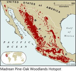
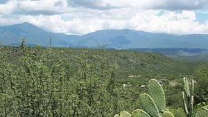
The Madrean pine–oak woodlands are subtropical woodlands found in the mountains of Mexico and the southwestern United States. They are a biogeographic region of the tropical and subtropical coniferous forests and temperate broadleaf and mixed forests biomes, located in North America.

<span class="mw-page-title-main">Sierra Madre Occidental pine–oak forests</span> Temperate broadleaf and mixed forests ecoregion of Mexico and the United States

The Sierra Madre Occidental pine–oak forests are a Temperate broadleaf and mixed forests ecoregion of the Sierra Madre Occidental range from the southwest USA region to the western part of Mexico. They are home to a large number of endemic plants and important habitat for wildlife.

<span class="mw-page-title-main">Sierra Madre de Oaxaca</span> Mountain range in southern Mexico

The Sierra Madre de Oaxaca is a mountain range in southern Mexico. It is primarily in the state of Oaxaca, and extends north into the states of Puebla and Veracruz.

<span class="mw-page-title-main">Mexican Plateau</span> Region in Mexico

The Central Mexican Plateau, also known as the Mexican Altiplano, is a large arid-to-semiarid plateau that occupies much of northern and central Mexico. Averaging 1,825 m (5,988 ft) above sea level, it extends from the United States border in the north to the Trans-Mexican Volcanic Belt in the south, and is bounded by the Sierra Madre Occidental and Sierra Madre Oriental to the west and east, respectively.

<span class="mw-page-title-main">Veracruz moist forests</span> Tropical moist broadleaf forests ecoregion of Mexico

The Veracruz moist forests is a tropical moist broadleaf forests ecoregion in eastern Mexico.

<span class="mw-page-title-main">Sierra Madre Oriental pine–oak forests</span> Temperate broadleaf and mixed forests ecoregion of Mexico and the United States

The Sierra Madre Oriental pine–oak forests are a temperate broadleaf and mixed forest ecoregion of northeastern and Central Mexico, extending into the state of Texas in the United States.

<span class="mw-page-title-main">Trans-Mexican Volcanic Belt pine–oak forests</span> Tropical and subtropical coniferous forests ecoregion in Mexico

The Trans-Mexican Volcanic Belt pine–oak forests is a subtropical coniferous forest ecoregion of the Trans-Mexican Volcanic Belt of central Mexico.

<span class="mw-page-title-main">Tamaulipan mezquital</span> Xeric shrublands ecoregion in Mexico and the United States

The Tamaulipan mezquital is a deserts and xeric shrublands ecoregion in the Southern United States and northeastern Mexico. It covers an area of 141,500 km2 (54,600 sq mi), encompassing a portion of the Gulf Coastal Plain in southern Texas, northern Tamaulipas, northeastern Coahuila, and part of Nuevo León.

<span class="mw-page-title-main">Tehuacán Valley matorral</span> Xeric shrubland ecoregion in Mexico

The Tehuacán Valley matorral is a xeric shrubland ecoregion, of the deserts and xeric shrublands biome, located in eastern Central Mexico.

<span class="mw-page-title-main">Gómez Farías Municipality, Tamaulipas</span> Municipality in Tamaulipas, Mexico

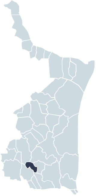
Gómez Farías Municipality is situated in the Mexican state of Tamaulipas. The town of Gómez Farías serves as the municipal seat of government. Covering an area of 433 square kilometres, Gómez Farías Municipality had a population of 8,786 as of 2010. The town of Gómez Farías, specifically, had a population of 883 in the same year. Additionally, within the municipal area, a portion of 23,124 hectares is encompassed by the El Cielo Biosphere Reserve.

<span class="mw-page-title-main">Llera de Canales, Tamaulipas</span>

Llera de Canales is a municipality located in the Mexican state of Tamaulipas. Also called Llera, the municipality has an area of 2,307 square kilometres (891 sq mi) and a 2010 population of 17,333. The population of the town of Llera is 4,148. Llera was founded December 25, 1748 and later renamed Llera de Canales.

<span class="mw-page-title-main">Chilean Matorral</span> Mediterranean forests, woodlands, and scrub ecoregion in central Chile

The Chilean Matorral (NT1201) is a terrestrial ecoregion of central Chile, located on the west coast of South America. It is in the Mediterranean forests, woodlands, and scrub biome, part of the Neotropical realm.

<span class="mw-page-title-main">Central Mexican matorral</span> Xeric shrubland ecoregion in Mexico

The Central Mexican matorral is an ecoregion of the deserts and xeric shrublands biome of central Mexico. It is the southernmost ecoregion of the Nearctic realm.

Esenbeckia runyonii is a species of flowering tree in the citrus family, Rutaceae, that is native to northeastern Mexico, with a small, disjunct population in the Lower Rio Grande Valley of Texas in the United States. Common names include Limoncillo and Runyon's Esenbeckia. The specific epithet honors Robert Runyon, a botanist and photographer from Brownsville, Texas, who collected the type specimen from a stand of four trees discovered by Harvey Stiles on the banks of Resaca del Rancho Viejo, Texas, in 1929. Conrad Vernon Morton of the Smithsonian Institution received the plant material and formally described the species in 1930. Some consider it a synonym of E. berlandieriBaill. ex Hemsl..

The Sierra de Tamaulipas is an isolated, semi-tropical mountain range in the Mexican state of Tamaulipas. Its highest point is 1,260 m (4,130 ft). There are no cities or towns in the Sierra and the small population is largely agricultural. The higher elevations of the Sierra have forests of oak and pine, contrasting with the semi-arid brush that dominates at lower altitudes. Several archaeological sites establish that the Sierra de Tamaulipas was the northern outpost of the agricultural Mesoamerican peoples of eastern Mexico.

The Sierra de Picachos is a mountain range located in the state of Nuevo Leon, Mexico. The highest peak in the range reaches an elevation of 4,990 feet (1,521 m) at 26° 03′ 54″ North Latitude and 99° 54′ 56″ West Longitude.

The Sierra del Burro is the northernmost finger of the Sierra Madre Oriental in the state of Coahuila, Mexico. The Sierra begins at the Rio Grande near Big Bend National Park in Texas and extends southeast for about 70 miles (100 km), reaching a maximum elevation of 2,074 metres (6,804 ft).

<span class="mw-page-title-main">El Cielo Biosphere Reserve</span> Natural reserve in Mexico

The El Cielo Biosphere Reserve is located in the Sierra Madre Oriental in the southern part of the Mexican state of Tamaulipas near the town of Gómez Farias. The reserve protects the northernmost extension of tropical forest and cloud forest in Mexico. It has an area of 144,530 hectares made up mostly of steep mountains rising from about 200 metres (660 ft) to a maximum altitude of more than 2,300 metres (7,500 ft).

<span class="mw-page-title-main">Meseta Central matorral</span> Xeric shrubland ecoregion in Mexico

The Meseta Central matorral is a deserts and xeric shrublands ecoregion in north-central Mexico.

References

  1. 1 2 3 "Tamaulipan matorral". Terrestrial Ecoregions. World Wildlife Fund. Retrieved 2011-11-20.
  2. Olson, David M.; Eric Dinerstein (2002). "The Global 200: Priority Ecoregions for Global Conservation" (PDF). Annals of the Missouri Botanical Garden. 89 (2): 199–224. doi:10.2307/3298564. JSTOR   3298564.
  3. 1 2 "Tamaulipan matorral". DOPA Explorer. Accessed 15 October 2021.