Tame, Arauca

Last updated
Tame, Arauca
Municipality and town
Flag of Tame (Arauca).svg
Escudo de Tame (Arauca).svg
Colombia - Arauca - Tame.svg
Location of the municipality and town of Tame, Arauca in the Arauca Department of Colombia
CountryFlag of Colombia.svg  Colombia
Department Arauca Department
FoundedJune 12, 1628
Government
  MayorAnibal Mendoza Bohorquez (2020-2023)
Area
   Municipality and town5,419 km2 (2,092 sq mi)
  Urban
9.46 km2 (3.65 sq mi)
Elevation
340 m (1,115.49 ft)
Population
 (2018 census) [1]
   Municipality and town43,932
  Density8.1/km2 (21/sq mi)
   Urban
26,784
  Urban density2,800/km2 (7,300/sq mi)
Time zone UTC-5 (Colombia Standard Time)
Climate Am

Tame is a town and municipality in the Arauca Department, Colombia. The municipality has a total area of around 5,419 square kilometres or 2,090 square miles.

Contents

History

The region was explored by the German conquistador Jorge de Espira in 1536. There he encountered several Indian tribes from the Arawakan and the Goajiboan language families; Arauca, Caquetio, Lucalia, Girara, Chiricoa, Cuiba, Guahibo and Achagua. The Girara people lived at the exact location of the modern town (or closest to).

Tame was founded by Alonso Pérez de Guzmán on June 12, 1628. He also founded "Espinosa de las Palmas" nearby, for civilian Spaniards. The village was destroyed a few years later by the natives in confrontations in which Pérez de Guzmán and his soldiers were killed by the Girara Indians of Tame in revenge for the slavery treatment.

Geography

The municipality of Arauca borders to the north with the municipality of Fortul, to the northeast with the municipality of Arauquita, to the east with the municipality of Puerto Rondón, to the south with the Casanare Department and to the west with the Boyacá Department.

Climate

Tame has a tropical monsoon climate (Köppen Am) with moderate to little rainfall from December to March and heavy to very heavy rainfall from April to November.

Climate data for Tame, elevation 350 m (1,150 ft), (1981–2010)
MonthJanFebMarAprMayJunJulAugSepOctNovDecYear
Mean daily maximum °C (°F)32.0
(89.6)
32.1
(89.8)
32.0
(89.6)
32.3
(90.1)
31.5
(88.7)
31.1
(88.0)
30.9
(87.6)
31.2
(88.2)
31.5
(88.7)
32.1
(89.8)
32.1
(89.8)
31.8
(89.2)
31.6
(88.9)
Daily mean °C (°F)26.3
(79.3)
26.5
(79.7)
26.7
(80.1)
26.2
(79.2)
26.0
(78.8)
25.5
(77.9)
25.4
(77.7)
25.5
(77.9)
25.7
(78.3)
26.0
(78.8)
26.1
(79.0)
26.3
(79.3)
26
(79)
Mean daily minimum °C (°F)22.9
(73.2)
22.9
(73.2)
22.9
(73.2)
22.7
(72.9)
22.5
(72.5)
22.0
(71.6)
22.1
(71.8)
22.0
(71.6)
22.2
(72.0)
22.5
(72.5)
22.6
(72.7)
22.4
(72.3)
22.5
(72.5)
Average precipitation mm (inches)28.3
(1.11)
36.9
(1.45)
69.7
(2.74)
187.2
(7.37)
289.7
(11.41)
303.7
(11.96)
294.4
(11.59)
247.1
(9.73)
211.0
(8.31)
205.5
(8.09)
110.2
(4.34)
32.3
(1.27)
1,903.3
(74.93)
Average precipitation days (≥ 1.0 mm 3)3461318171615121384120
Average relative humidity (%)81808384858686868584838384
Source: Instituto de Hidrologia Meteorologia y Estudios Ambientales [2]

Related Research Articles

<span class="mw-page-title-main">Boyacá Department</span> Department of Colombia

Boyacá is one of the thirty-two departments of Colombia, and the remnant of Boyacá State, one of the original nine states of the "United States of Colombia".

<span class="mw-page-title-main">Arauca Department</span> Department of Colombia

Arauca is a department of Eastern Colombia located in the extreme north of the Orinoco Basin of Colombia, bordering Venezuela. The southern boundary of Arauca is formed by the Casanare and Meta Rivers, separating Arauca from the departments of Casanare and Vichada. To the west, Arauca borders the department of Boyacá. The Caño Limón oil fields located within Arauca account for almost a third of the Colombian oil output. Its capital is the town of Arauca.

<span class="mw-page-title-main">Arauca, Arauca</span> Municipality and city in Arauca Department, Colombia

Arauca is a municipality and capital city of the Arauca Department of Colombia. Its full name is Villa de Santa Bárbara de Arauca, it is located at N 07° 05′ 25″ - W 70° 45′ 42″. The Municipality of Arauca has a total population of 85,585.

<span class="mw-page-title-main">Apartadó</span> Municipality in Antioquia Department, Colombia

Apartadó is a town and municipality in the Antioquia Department, Colombia. It is part of the Urabá sub-region.

<span class="mw-page-title-main">Cañasgordas</span> Municipality and town in Antioquia Department, Colombia

Cañasgordas is a town and municipality in Antioquia Department, Colombia. The population was 13,595 at the 2018 census.

<span class="mw-page-title-main">Heliconia, Antioquia</span> Municipality and town in Antioquia Department, Colombia

Heliconia is a town and municipality in Antioquia Department, Colombia.

<span class="mw-page-title-main">Necoclí</span> Municipality and town in Antioquia Department, Colombia

Necoclí is a town and municipality in Antioquia Department, Colombia. Located on the eastern shore of the Gulf of Urabá, it is part of the Urabá Antioquia sub-region. The population is predominantly Afro-Colombian.

<span class="mw-page-title-main">Saravena</span> Municipality and town in Arauca Department, Colombia

Saravena is a city and municipality in Arauca Department, Colombia. It is located 6 kilometres (3.7 mi) south of Colombia's border with Venezuela. The municipality, with a population of 55,554, has had FARC and ELN activity as well as a Colombian military presence near the Venezuelan border.

<span class="mw-page-title-main">Guaranda, Sucre</span> Municipality and town in Sucre Department, Colombia

Guaranda is a town and municipality located in the Sucre Department, northern Colombia.

<span class="mw-page-title-main">El Guacamayo</span> Municipality and town in Santander Department, Colombia

El Guacamayo is a town and municipality in the Santander Department in northeastern Colombia.

<span class="mw-page-title-main">Arauquita</span> Municipality and town in Arauca Department, Colombia

Arauquita is a town and municipality in the Arauca Department, Colombia. As of 2020, the municipality has a population of 56,209.

<span class="mw-page-title-main">Cravo Norte</span> Municipality and town in Arauca Department, Colombia

Cravo Norte is a town and municipality in the Arauca Department, Colombia. It is thought to have been founded in 1538 by the Jesuit missionary Joseph Gumilla. The first census was conducted in May 1797 and counted a population of 205.

<span class="mw-page-title-main">Fortul</span> Municipality and town in Arauca Department, Colombia

Fortul is one of the seven municipalities of the Colombian department of Arauca. It limits to the north with Saravena; to the south with Tame; to the east with Arauquita and to the west with Güicán. It was founded on January 7, 1920. According to the census conducted by the DANE in 2005, Fortul has a population of 25,379 inhabitants, of which 13,081 live in the municipal seat making it 49.5% women and 50.5% men.

<span class="mw-page-title-main">Aguadas, Caldas</span> Municipality and town in Caldas Department, Colombia

Aguadas is a town and municipality in the Colombian department of Caldas. It is bordered to the north by Abejorral, to the east by Sonsón, to the southeast by Salamina, to the south by Pacora, to the west by Caramanta and Valparaiso, and to the northwest by La Pintada. The municipality of Aguadas, located in the northern part of the department, was founded in 1808 by José Narciso Estrada. In addition to the fame of Aguadeño hats, which are very similar to palm-straw Panama hats. Aguadas offers visitors its historic center, which was declared a national monument in 1982. It has a temperate climate thanks to the variety of climates ranging from warm to moor.

<span class="mw-page-title-main">Quípama</span> Municipality and town in Boyacá, Colombia

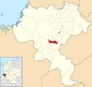
Quípama is a town and municipality in the Colombian Department of Boyacá, part of the subregion of the Western Boyacá Province.

<span class="mw-page-title-main">Güicán</span> Municipality in the department of Boyacá, Colombia

Güicán de la Sierra, also known as Nuestra Señora de la Candelaria de Güicán, is a town and municipality in the Colombian Department of Boyacá. It is close to the national natural park El Cocuy National Park. As of the year 2020, it has a total population of 6,426.

<span class="mw-page-title-main">Pajarito, Boyacá</span> Municipality and town in Boyacá Department, Colombia

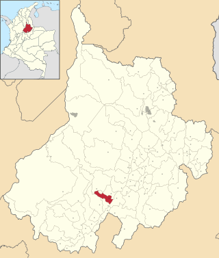
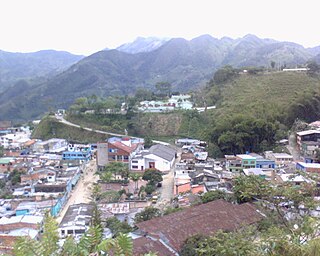
Pajarito is a town and municipality in the La Libertad Province, part of the Colombian department of Boyacá. The municipality, situated in the southeast of the department borders Labranzagrande and Aquitania of the department of Boyacá and Yopal, Recetor and Aguazul of the department of Casanare. The urban centre is located at a distance of 147 kilometres (91 mi) from the department capital Tunja at an altitude of 800 metres (2,600 ft) in a tight valley, not allowing much expansion of the urban area. The centre is experiencing periodic landslides.

<span class="mw-page-title-main">Campohermoso</span> Municipality and town in Boyacá Department, Colombia

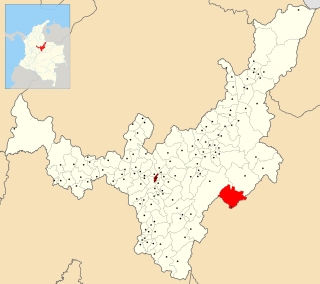
Campohermoso is a town and municipality in the Colombian Department of Boyacá, part of the subregion of the Lengupá Province.

<span class="mw-page-title-main">La Sierra, Cauca</span> Municipality and town in Cauca Department, Colombia

La Sierra is a town and municipality in the Cauca Department, Colombia.

<span class="mw-page-title-main">Pitiquito</span> Place in Sonora, Mexico

Pitiquito is a small town in Pitiquito Municipality in the northwest of the Mexican state of Sonora.

References

  1. Citypopulation.de Population of Tame municipality with localities
  2. "Promedios Climatológicos 1981–2010" (in Spanish). Instituto de Hidrologia Meteorologia y Estudios Ambientales. Archived from the original on 15 August 2016. Retrieved 3 June 2024.

6°28′N71°44′W / 6.467°N 71.733°W / 6.467; -71.733