Tantramar Marshes

Last updated
A hay barn of a type once numerous on the Tantramar Marsh. Tantramar Barn1.jpg
A hay barn of a type once numerous on the Tantramar Marsh.

The Tantramar Marshes, also known as the Tintamarre National Wildlife Area, is a tidal saltmarsh around the Bay of Fundy on the Isthmus of Chignecto. The area borders between Route 940, Route 16 and Route 2 near Sackville, New Brunswick. The government of Canada proposed the boundaries of the Tantramar Marshes in 1966 and was declared a National Wildlife Area in 1978.

Contents

The marshes are an important stopover for migrating waterfowl such as semipalmated sandpipers and Canada geese. Now a National Wildlife Area, the marshes are the site of two bird sanctuaries.

The name Tantramar is derived from the Acadian French tintamarre, meaning 'din' or 'racket', a reference to the noisy flocks of birds which feed there.

The Mi'kmaq, an Indigenous nation, historically inhabited the surrounding areas of the Tantramar Marshes. Communities currently on or bordering the marshes include, in New Brunswick: Aulac and Sackville, and on the Nova Scotia side: Amherst, and Fort Lawrence.

The landscape of the Tantramar Marshes has provided subject matter for the poets Charles G.D. Roberts, Bliss Carman, Douglas Lochhead, Marilyn Lerch and Elizabeth Bishop, painter Alex Colville, and photographer Thaddeus Holownia.

National wildlife area status

Map of protected areas in New Brunswick. Tintamarre National Wildlife Area is highlighted in dark red near the border of New Brunswick and Nova Scotia. Protected areas of New Brunswick map-blank.svg
Map of protected areas in New Brunswick. Tintamarre National Wildlife Area is highlighted in dark red near the border of New Brunswick and Nova Scotia.

The boundaries of Tintamarre National Wildlife Area were proposed in 1966 for the National Habitat Protection Program, through the government of Canada. [1] The land was acquired by the Canadian Government up until the mid 1970s and officially declared a National Wildlife Area in 1978. [1] Tintamarre Marshes consists of 1960 hectares that consist primarily of wetlands and historic agricultural land. [2] Two additional units to the area are being proposed but unofficial, surrounding Hog Lake and Towers Goose Lake. [1]

National Wildlife areas like Tintamarre are created to manage and protect native wildlife. [3] Tintamarre Marsh is a breeding area for several types of waterfowl, and home to numerous plants and animals. [1] Environment and Climate Change Canada manages the well being of the various species in Tintamarre and their long time goal is “to maintain and enhance habitat for native wildlife, with a priority given to waterfowl, wetland birds and species at risk.” as outlined in a 2016 report. [1] Seven management goals were outlined: wetland diversity, open fields, upland habitat, fish passage, invasive species, human activity, and exterior forces. [1]

Many of the threats posed to the National Wildlife Area are of anthropogenic origin. Unauthorized activities such as camping - including fires, - off road vehicle use, and an overall increase in tourism have the potential to harm and destroy the vulnerable habitat. [1] Other human-based concerns include nearby wind power farms disrupting migratory bird populations and fish pathways for diadromous species no longer functioning as intended. [1] [4] Other threats threats include invasive species outcompeting native wildlife and climate change. [1]

Natural environment

Wildlife

Muskrat. Visually similar to a beaver, but slightly smaller and with a rounder, longer tail. Ondatra zibethicus FWS.jpg
Muskrat. Visually similar to a beaver, but slightly smaller and with a rounder, longer tail.

The Tantramar Marsh is a saltwater tidal marsh comprising many interconnecting waterways. [5] Much of the area is below sea level, but instances of flooding are prevented by the soft ground and plant life which withhold water and filter out toxins. [5] [6] This mix of fresh and saltwater creates unique ecosystems for many species, mostly birds and fish. [5] The word “Tantramar” comes from the French “tintamarre” which means “din”, a reference to the cacophony of noise made by the local waterfowl. [5] The environment provides a good stop-over for birds migrating between northern Canada and warmer, southern climates. [7] The marshes are home to species such as the Northern harrier (Circus hudsonius), American bittern (Botaurus lentiginosus), Sora (Porzana carolina), muskrat (Ondatra zibethicus), and maritime shrew (Sorex maritimensis), all of which are vital to the marsh’s ecological systems. [2] [8] [9]

Keystone species

The presence of these keystone species ensures the continued vitality of the marshes and the ecosystems that they support. The Northern harrier is a bird of prey, feeding on small rodents which eat grass seeds and the eggs and young of other birds. [10] The American bittern and Sora are elusive waterfowl which are highly sensitive to changes in their environment, so they have been classified as indicator species. [5] A decrease in their populations alerts conservationists to issues in the marshes such as degradation, loss of prey species, or human interference. [11] The muskrat is a rat-sized rodent which has evolved to become semi-aquatic. [8] They feed on cattails and yellow water lilies, creating open water areas that best suit waterfowl, fish, and frogs. [12] The Maritime shrew is another rodent, slightly smaller than the muskrat, which responds to increasing numbers of insects and goes on a feasting spree. [13] It keeps these numbers down and prevents insects from becoming too numerous. [13]

Flock of Red-Knots, designated as "at risk" under the Species at Risk Act Red-Knot (Calidris canutus) RWD3.jpg
Flock of Red-Knots, designated as "at risk" under the Species at Risk Act

Species at risk

The marshes are also home to numerous species at risk as designated under the Species at Risk Act (SARA). [2] Bird species include the barn swallow (Hirundo rustica), chimney swift (Chaetura pelagica), Canada warbler (Cardellina canadensis), olive-sided flycatcher (Contopus cooperi), bobolink (Dolichonyx oryzivorus), common nighthawk (Chordeiles minor), red knot (Calidris canutus), least bittern (Ixobrychus exilis), eastern meadowlark (Sturnella magna), and short-eared owl (Asio flammeus). [2] [14] The American eel (Anguilla rostrata) also makes its home here as it can breed in the Gulf’s salt water and migrate the short distance to fresh river water in the marshes. [15] The Atlantic salmon (Salmo salar) also enjoys the mix of salt and fresh water – the eggs are laid in the clean waters of rivers and streams where the young can feed and grow safely. [3] [16] Once large enough, they migrate to the salt waters of the gulf until they are ready to return to the marsh to breed. [16] The monarch butterfly (Danaus plexippus) breeds in the marshes during the summer months, thanks to the presence of its Host plant Milkweed. [3] [17]

Closer look at the anatomy of Salt-water cordgrass. Spartina patens BB-1913.png
Closer look at the anatomy of Salt-water cordgrass.

Plant life

With its ability to thrive in exposed environments with low-lying landscapes, Spartina dominates the plant life in the Tantramar marshes. [18] The spartina is essential in stabilizing clay, sand, silt, and muck of the saltmarshes. [18] [19] Saltwater cordgrass (Spartina alternifolia) grows closest to water in the low marshlands along the boundaries of the tidal rivers and are flooded daily with salt water (about 12-15%). [18] [19] Salt-meadow cordgrass (Spartina patens) grow in the high marshlands and are only flooded 2% of the time allowing them to grow taller than saltwater cordgrass. [19] Another type of grass plant is the freshwater cordgrass (Spartina pectinata) which can obtain freshwater runoff from uplands allowing them to grow the tallest of the three. Freshwater cordgrass gets flooded a few times throughout the year during high tides in spring. [19]

Additionally to spartina, located in the middle marshlands, there are two plants that are a part of a low-growing succulent plant family. [18] The samphire ( Salicornia europaea ) and seablite ( Suaeda maritima ) grow in bare mud that is located in the middle area that sits just above the high tides of the marshland. [18] In the high marshlands, there is sea lavender ( Limonium carolinianum ), arrow-grass ( Triglochin maritima ), seaside plantain ( Plantago juncoides), seamilkwort ( Glaux maritima ), and love-grass ( Eragrostis sp.). [18] In naturally forming lakes, there are several plant species belonging to the genus Nuphar . Due to better water and soil drainage, these plants are able to prosper. These species include water lilies, Bladderwort (Utricularia), Buckbean (Menyanthes), mare’s tail ( Hippuris vulgaris ), and Pondweed (Potamogeton natans, P. spirrilus). [18]

One of the dykes around Tantramar Marsh. Protects the land from large waves and potential flooding. Shown here as a high wall that pedestrians can travel along. On Dyke near Fort Beausejour, NB (212861144).jpg
One of the dykes around Tantramar Marsh. Protects the land from large waves and potential flooding. Shown here as a high wall that pedestrians can travel along.

Climate change

As with most wildlife protection areas, climate change poses a serious threat to the ecology of the Tantramar marsh. Climate change introduces rising temperatures, increases in storm frequency and severity, and rising sea levels which will result in the flooding of low lying land and coastal areas. [20] [21] The rise in temperature is creating new environments in which invasive species and diseases can survive while native species struggle to adapt. [20] Storms bring in unusual levels of precipitation and strong winds which can damage the fragile ecosystems of the marsh and the dykes in New Brunswick which help prevent flooding from the Gulf of Maine. [22] Rising sea levels increase the threat of flooding too much for the marshes to be able to regulate. [18] If Tintamarre National Wildlife Area were to flood with enough sea-water it would cause large scale die-offs and damage for the freshwater species that inhabit the freshwater wetlands. [1] [23] Water from flooding via dyke failure or from increased and more intense storms due to climate change will also lead to accelerated Erosion, [24] [25] draining the wetland of many important nutrients.

Uses of the marsh

For a full account of human activity on the marshes, see the History of Sackville.

Mi'kmaq peoples weaving baskets next to a lodge of tar and canvas; 1941 Mikmaq braiding baskets, Indian Island (27750).jpg
Mi'kmaq peoples weaving baskets next to a lodge of tar and canvas; 1941

Historical uses

The Mi’kmaq are the Indigenous peoples of Tantramar marshes and surrounding areas, they have many traditional uses for the resources in this area. The marsh was used for harvesting of different kinds of plants, wildfowl, small mammals and fish as means of food. [26] Before the arrival of Europeans, well-travelled portage routes connected the Bay of Fundy with the Northumberland Strait as the marsh was used seasonally. [26] As years passed and different settlers came to the Tantramar marshes the use of these resources changed, going from the fish weirs of the Mi'kmaq to the creation of dry farming by the Acadians from the creation of sluice gates to keep out water where the rivers crossed the dykes in order for planting to take place. [27]

Migrating from Port Royal in around 1671, Acadians established a village in the area (which they called Beaubassin [28] ). They founded a number of scattered settlements on higher ground, and created dry farmland using polderisation, by building the dykes and sluices which converted the salt marshes to fields and pastures. Following the Battle of Fort Beauséjour which marked the end of the battle for Acadia between the British and French, it was the site of the beginning of the expulsion of the Acadians in 1755. Six years later the British resettled the area, and continued to convert the marsh to arable land, drying the land in order to plant crops for agricultural practices. [29]

The now-decommissioned RCI transmitter station in 2009. RCI Tantramar.jpg
The now-decommissioned RCI transmitter station in 2009.

During the 19th century the land use in and around the Tantramar region changed, land ownership became consolidated and a Commission of Sewers was established, which was crucial to the economy. By the mid-1800s, 10,000 hectares was producing grains, root crops, and marsh hay. [30] Once turned into polders, the cost of producing hay was low. Inexpensive Tantramar hay was then sold to lumber camps, exploration, and mining in Atlantic Canada and stables as far away as Boston. In the 1930s there were more than 400 post-and-beam hay barns on the marshes, for hay storage. Today there are fewer than 30. The price of hay was $28 per ton in 1920, but as horses were replaced by cars and as manufacturing moved west, the hay price fell to $7 a ton in 1938. The marshes then became pasture, and as their agricultural profitability declined the Canadian Wildlife Service and Ducks Unlimited helped to return the marshes to a more natural state. [31] After 2010 fears emerged that rising sea levels and deterioration of 18th-century hand-built dykes and sluices threatened to flood the Tantramar Marshes and make Nova Scotia into an island separate from the North American mainland. [32]

Fishing for Atlantic salmon, a popular pastime that must be monitored using permits and licenses. Atlantic Salmon Fishing Cains River New Brunswick (8376386310).jpg
Fishing for Atlantic salmon, a popular pastime that must be monitored using permits and licenses.

In 1945 Radio Canada International opened a radio transmitter and the site proved to be one of the best shortwave transmitting locations in the world. [33] Shortwave broadcasting ended in 2012 and transmitting towers have since been removed. [34] In 2017, the CBC announced that the site had been sold to a non-profit consortium of New Brunswick Mi'kmaq bands known as Mi'gmawe'l Tplu'taqnn. The intended use of the property was not disclosed. [35]

Present uses

The declaration of the Tantramar Marshes as a protected area resulted in many restrictions being imposed with how the land and water surrounding it can be accessed and used. [2] Visitors are given access to the protected area for things like leisure activities, which include swimming, having group events and meals, using the trails for hikes, boating, skiing/snowboarding and skating. [2] Sport hunting of specific animals is allowed, as long as the required permits have been attained and regulations are followed. [2] Fishing is also allowed but limits are imposed to avoid overfishing, a permit is also required for sport fishing. [2] Any access to the Tintamarre National Wildlife Area, and with regards to all the above-mentioned uses of the park, are only permitted from sunrise to sunset. [2] Use outside of those times is against the Law. [2]

See also

Related Research Articles

<span class="mw-page-title-main">Bay of Fundy</span> Bay on the east coast of North America

The Bay of Fundy is a bay between the Canadian provinces of New Brunswick and Nova Scotia, with a small portion touching the U.S. state of Maine. It is an arm of the Gulf of Maine. Its tidal range is the highest in the world. The name is probably a corruption of the French word fendu, meaning 'split'.

<span class="mw-page-title-main">Marsh</span> Low-lying and seasonally waterlogged land

A marsh is — according to ecological definitions — a wetland that is dominated by herbaceous rather than woody plant species. More in general, the word can be used for any low-lying and seasonally waterlogged terrain. In Europe and in agricultural literature low-lying meadows that require draining and embanked polderlands are also referred to as marshes or marshland.

<span class="mw-page-title-main">Cap Tourmente National Wildlife Area</span> National Wildlife Area in Quebec, Canada

The Cap Tourmente National Wildlife Area is a National Wildlife Area (NWA) located on the north shore of the Saint Lawrence River in the National Provincial Capital Region of Quebec, established on 28 April 1978. It is one of the critical habitats for the greater snow goose during migration. Flocks of tens of thousands of these birds stop over to feed on the bullrushes in the spring and fall. The tidal marsh was recognized as a wetland of international significance per the Ramsar Convention in 1981, the first North American site to receive that distinction.

<span class="mw-page-title-main">Salt marsh</span> Coastal ecosystem between land and open saltwater that is regularly flooded

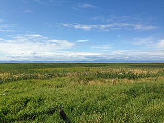
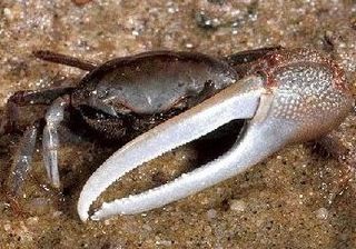
A salt marsh, saltmarsh or salting, also known as a coastal salt marsh or a tidal marsh, is a coastal ecosystem in the upper coastal intertidal zone between land and open saltwater or brackish water that is regularly flooded by the tides. It is dominated by dense stands of salt-tolerant plants such as herbs, grasses, or low shrubs. These plants are terrestrial in origin and are essential to the stability of the salt marsh in trapping and binding sediments. Salt marshes play a large role in the aquatic food web and the delivery of nutrients to coastal waters. They also support terrestrial animals and provide coastal protection.

<span class="mw-page-title-main">Sackville, New Brunswick</span> Place in New Brunswick, Canada

Sackville is a former town in southeastern New Brunswick, Canada. It held town status prior to 2023 and is now part of the town of Tantramar.

<span class="mw-page-title-main">Tantramar Heritage Trust</span> Organization

The Tantramar Heritage Trust is a non-profit charity that promotes the preservation of heritage buildings, artefacts and lands in an area of south-east New Brunswick along the Nova Scotia border known as the "Tantramar". This region, which is centred on Sackville, New Brunswick and Amherst, Nova Scotia is characterised by an ecologically significant coastal lowland known as the Tantramar Marshes, which encompasses the Tintamarre National Wildlife Area.

<i>Sporobolus alterniflorus</i> Species of aquatic plant

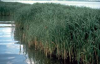
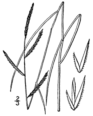
Sporobolus alterniflorus, or synonymously known as Spartina alterniflora, the smooth cordgrass, saltmarsh cordgrass, or salt-water cordgrass, is a perennial deciduous grass which is found in intertidal wetlands, especially estuarine salt marshes. It has been reclassified as Sporobolus alterniflorus after a taxonomic revision in 2014, but it is still common to see Spartina alterniflora and in 2019 an interdisciplinary team of experts coauthored a report published in the journal Ecology supporting Spartina as a genus. It grows 1–1.5 m tall and has smooth, hollow stems that bear leaves up to 20–60 cm long and 1.5 cm wide at their base, which are sharply tapered and bend down at their tips. Like its relative saltmeadow cordgrass S. patens, it produces flowers and seeds on only one side of the stalk. The flowers are a yellowish-green, turning brown by the winter. It has rhizoidal roots, which, when broken off, can result in vegetative asexual growth. The roots are an important food resource for snow geese. It can grow in low marsh as well as high marsh, but it is usually restricted to low marsh because it is outcompeted by salt meadow cordgrass in the high marsh. It grows in a wide range of salinities, from about 5 psu to marine, and has been described as the "single most important marsh plant species in the estuary" of Chesapeake Bay. It is described as intolerant of shade.

<span class="mw-page-title-main">Erie National Wildlife Refuge</span>

The Erie National Wildlife Refuge is an 8,777-acre (3,552 ha) National Wildlife Refuge located in Crawford County, Pennsylvania. Named after the Erie tribe, it was established to provide waterfowl and other migratory birds with nesting, feeding, brooding, and resting habitat.

<span class="mw-page-title-main">Alaksen National Wildlife Area</span> National Wildlife Area of Canada in Delta, British Columbia

The Alaksen National Wildlife Area is located on Westham Island in the city of Delta, British Columbia. It is an important stopover point for many species of birds migrating along the Pacific Flyway.

<span class="mw-page-title-main">Oak Hammock Marsh</span> Marsh in Manitoba, Canada

Oak Hammock Marsh is a marsh and a wildlife management area located 34 kilometres (21 mi) north of Winnipeg, Manitoba, Canada. The WMA is considered to be a Class IV protected area under the IUCN protected area management categories. The marsh is recognized as an Important Bird Area (IBA) for its globally significant numbers of waterfowl and shorebirds. It is a designated Ramsar site due to its international importance as a breeding and staging area for waterfowl and other migratory birds. It is 3,578.47 hectares in size.

<span class="mw-page-title-main">Currituck National Wildlife Refuge</span> National Wildlife Refuge in North Carolina, United States

Currituck National Wildlife Refuge, located on the northern end of North Carolina's Outer Banks, was established in 1984 to preserve and protect the coastal barrier island ecosystem. Refuge lands are managed to provide wintering habitat for waterfowl and to protect endangered species such as piping plover, sea turtles, and seabeach amaranth.

The John H. Chafee National Wildlife Refuge is a national wildlife refuge of the United States, located along the Narrow River on the southern coast of Rhode Island.

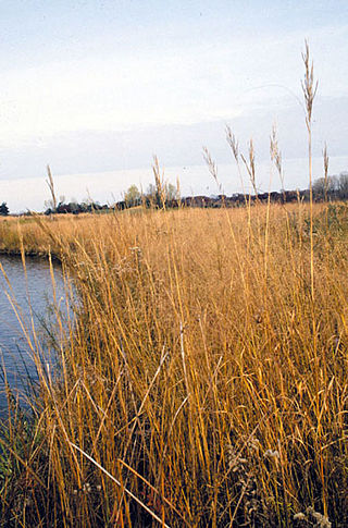
Low marsh is a tidal marsh zone located below the Mean Highwater Mark (MHM). Based on elevation, frequency of submersion, soil characteristics, vegetation, microbial community, and other metrics, salt marshes can be divided to into three distinct areas: low marsh, middle marsh/high marsh, and the upland zone. Low marsh is characterized as being flooded daily with each high tide, while remaining exposed during low tides.

<i>Sporobolus michauxianus</i> Species of grass

Sporobolus michauxianus is a species of cordgrass known as prairie cordgrass, freshwater cordgrass, tall marshgrass, and sloughgrass. It is native to much of North America, including central and eastern Canada and most of the contiguous United States except for the southwestern and southeastern regions. Its distribution extends into Mexico. It is also present on other continents as an introduced species.

Pass a Loutre Wildlife Management Area (WMA) is a 66,000-acre (270 km2) protected wetland in Plaquemines Parish, Louisiana, United States. The WMA is located due south and bordering the 48,000 acre Delta National Wildlife Refuge, accessible only by air or boat, contains the Pass A L'Outre Lighthouse, and Port Eads is within the boundary.

<span class="mw-page-title-main">William T. Davis Wildlife Refuge</span>

The William T. Davis Wildlife Refuge (WTDWR) is an 814-acre (3.29 km2) wildlife refuge straddling the New Springville and Travis sections of Staten Island. The park was named in honor of Staten Island native William T. Davis, a renowned naturalist and entomologist who along with the Audubon Society started the refuge with an original acquisition of 52 acres (210,000 m2). Additional acreage was acquired in increments and the park is today 814 acres (3.29 km2). Beginning in 2010, the adjacent 223-acre (0.90 km2) North Park section of Freshkills Park has undergone preparation to serve as an expansion of the wildlife refuge.

Tinatamarre is a word in Acadian French meaning "clangour" or "din", and may refer to:

<i>Sporobolus pumilus</i> Species of plant

Sporobolus pumilus, the saltmeadow cordgrass, also known as salt hay, is a species of cordgrass native to the Atlantic coast of the Americas, from Newfoundland south along the eastern United States to the Caribbean and north-eastern Mexico. It was reclassified after a taxonomic revision in 2014, but the older name, Spartina patens, may still be found in use. It can be found in marshlands in other areas of the world as an introduced species and often a harmful noxious weed or invasive species.

Widgeon Valley National Wildlife Area is a National Wildlife Area located near the south end of Pitt Lake in British Columbia, Canada. The property was purchased by the Nature Trust of British Columbia in 1973 and declared a National Wildlife Area by the Canadian Wildlife Service in October of that year. The Widgeon Valley National Wildlife Area is a biologically diverse marsh wetland. It is the traditional territory of various First Nations groups. The Widgeon Valley Wildlife Area is a protected wildlife area that is home to a number of sensitive waterfowl and fish species. The public uses the channels through the Widgeon Valley National Wildlife Area for recreational canoeing, anywhere else within the protected area is strictly off-limits to the public. There are future plans to develop interpretive trails through the park and open it to the public.

Located in the southern part of British Columbia, Columbia National Wildlife Area was established to protect its wetlands and as a temporary home for migratory birds travelling to South America. The National Wildlife Area (NWA) is divided into four unit areas: Wilmer, Spillimacheen, Brisco and Harrogate, which are home to many diverse species of animals and plants which are significant in Canada.

References

  1. 1 2 3 4 5 6 7 8 9 10 Environment and Climate Change Canada. 2016. Tintamarre National Wildlife Area Management Plan. Environment and Climate Change Canada, Canadian Wildlife Service, Atlantic Region, [47 pp.]
  2. 1 2 3 4 5 6 7 8 9 10 Canada, Environment and Climate Change (2011-12-21). "Tintamarre National Wildlife Area". www.canada.ca. Retrieved 2022-11-04.
  3. 1 2 3 Canada, Environment and Climate Change (2011-02-16). "Current national wildlife areas". www.canada.ca. Retrieved 2022-11-04.
  4. Roscoe, David W; Hinch, Scott G (February 11, 2010). "Effectiveness monitoring of fish passage facilities: historical trends, geographic patterns and future directions". Fish and Fisheries. 11 (1): 12–33. doi:10.1111/j.1467-2979.2009.00333.x.
  5. 1 2 3 4 5 "Tantramar Marsh | The Canadian Encyclopedia". www.thecanadianencyclopedia.ca. Retrieved 2022-10-11.
  6. "Tantramar Wetlands Centre" . Retrieved 2022-11-04.
  7. Belliveau, Renée. "Mount A Libraries: Marshland: Natural environment". libraryguides.mta.ca. Retrieved 2022-11-04.
  8. 1 2 "Hinterland Who's Who - Muskrat". www.hww.ca. Retrieved 2022-11-04.
  9. IUCN (2016). "Sorex maritimensis". IUCN Red List.
  10. Limas, Brian. "Circus cyaneus (northern harrier)". Animal Diversity Web. Retrieved 2022-11-04.
  11. "American Bittern (Botaurus lentiginosus)". wildlife-species.canada.ca. Retrieved 2022-11-04.
  12. thhruby@uwm.edu (2016-11-02). "And Now for Something a Little Different II". Field Station. Retrieved 2022-11-04.
  13. 1 2 Bragge, Laurie (November 2007), "Issues of Stability in the Southern Highlands Province" (PDF), Conflict and Resource Development: In The Southern Highlands of Papua New Guinea, ANU Press, retrieved 2022-10-11
  14. Bush, Peter (2019). "Ecological Landscape Analysis: Cumberland Marshes Ecodistrict 550" (PDF). Department of Lands and Forestry: 14–15 – via Government of Nova Scotia.
  15. "Species at risk registry". species-registry.canada.ca. Retrieved 2022-11-04.
  16. 1 2 Government of Canada, Fisheries and Oceans Canada (2018-10-26). "Atlantic salmon... a remarkable life cycle". www.dfo-mpo.gc.ca. Retrieved 2022-11-04.
  17. "Species at risk registry". species-registry.canada.ca. Retrieved 2022-11-04.
  18. 1 2 3 4 5 6 7 8 Aiden, Fudge (April 2019). Memory, Place & Change: A Landscape Narrative of the Tantramar Marshes (Thesis). University of Guelph.
  19. 1 2 3 4 Hood, Sabrina (2008). "Planning for Climate Change in Coastal Regions of Tantramar, New Brunswick: Risks and Recommendations"
  20. 1 2 "What does Climate Change Mean for Tantramar? - EOS Eco-Energy Inc" . Retrieved 2022-11-04.
  21. J., Shaw (1998), Sensitivity of the coasts of Canada to sea-level rise, Geological Survey of Canada, OCLC   290945072 , retrieved 2022-11-04
  22. EOS Eco-Energy Inc. (2016). "Corporate Climate Change Adaptation Plan" (PDF). Municipal Government of Sackville, NB: 9 – via Government of New Brunswick.
  23. "When Saltwater Intrusion Meets Freshwater Wetlands..." WMAP Blog - State of Delaware. 2018-03-07. Retrieved 2022-11-04.
  24. Wu, SY; Yarnal, B; Fisher, A (2002). "Vulnerability of coastal communities to sea-level rise: a case study of Cape May County, New Jersey, USA". Climate Research. 22: 255–270. doi: 10.3354/cr022255 . ISSN   0936-577X.
  25. Lieske, David J.; Wade, Tracey; Roness, Lori Ann (March 2014). "Climate change awareness and strategies for communicating the risk of coastal flooding: A Canadian Maritime case example". Estuarine, Coastal and Shelf Science. 140: 83–94. doi:10.1016/j.ecss.2013.04.017. ISSN   0272-7714.
  26. 1 2 "First People and the Marsh". Mount Allison University. Retrieved 14 October 2012.
  27. Belliveau, Renée. "Mount A Libraries: Marshland: Acadian settlement". libraryguides.mta.ca. Retrieved 2022-11-04.
  28. Louisiana Department of Culture, Recreation and Tourism. "Beaubassin Historical Marker".
  29. "Occupation by English-speaking Settlers" . Retrieved 14 October 2012.
  30. "Agricultural Improvement". Mount Allison University. Retrieved 14 October 2012.
  31. "The Marsh Economy and Society in the 20th-century". Mount Allison University. Retrieved 14 October 2012.
  32. "Nova Scotia could become an island . . ." https://www.cbc.ca/news/canada/nova-scotia/dike-tantramar-marsh-flooding-climate-change-rising-sea-levels-amherst-sackville-1.4403406; "Rising sea levels threaten marsh ecosystem and key transportation link . . ." https://www.cbc.ca/radio/thesundayedition/the-sunday-edition-for-june-14-2020-1.5604357/rising-sea-levels-threaten-marsh-ecosystem-and-key-transportation-link-between-atlantic-provinces-1.5604438.
  33. "CBA". Hammond Museum of Radio. Retrieved 14 October 2012.
  34. "RCI slashed". RCI. Retrieved 14 October 2012.
  35. "Sold! Mi'kmaq group confirms purchase of CBC land". Canadian Broadcasting Corporation. February 3, 2017. Retrieved 27 May 2017.

45°55′N64°18′W / 45.917°N 64.300°W / 45.917; -64.300