Related Research Articles
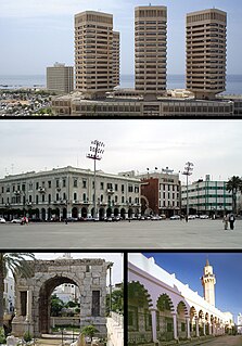
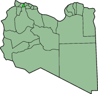
Tripoli is the capital and largest city of Libya, with a population of about 1.1 million people in 2019. It is located in the northwest of Libya on the edge of the desert, on a point of rocky land projecting into the Mediterranean Sea and forming a bay. It includes the port of Tripoli and the country's largest commercial and manufacturing center. It is also the site of the University of Tripoli. The vast Bab al-Azizia barracks, which includes the former family estate of Muammar Gaddafi, is also located in the city. Colonel Gaddafi largely ruled the country from his residence in this barracks.

Benghazi is a city in Libya. Located on the Gulf of Sidra in the Mediterranean, Benghazi is a major seaport and the second-most populous city in the country, as well as the largest city in Cyrenaica, with an estimated population of 807,250 in 2020.
ʽAziziya or El Azizia was one of the districts of Libya (baladiyah), located in the northwest of the country, south of Tripoli District. The town of ʽAziziya was the former district's capital, and it covered an area of 1,940 square kilometers. In 2001 ʽAziziya became part of the Jafara District.

Tripolitania, historically known as the Tripoli region, is a historic region and former province of Libya.

The Tripoli Grand Prix was a motor racing event first held in 1925 on a racing circuit outside Tripoli, the capital of what was then Italian Tripolitania, now Libya. It lasted until 1940.

Setapak is a mukim in Gombak District, Kuala Lumpur, Malaysia. Formerly a tin-mining and rubber-growing area, in Malay tapak means 'step' so Setapak means 'one step', probably referring to the close proximity of the suburb to Kuala Lumpur. Another explanation of the origin of its name traces to its historical roots.

Humbermede, often called Emery, is a neighbourhood of Toronto, Ontario, Canada. Humbermede, like many of the "Humber" neighbourhoods in the city, gets its name from the Humber River. It is bounded on the west by the Humber River, on the north by Finch Avenue West, on the east by the Highway 400 and on the south by Sheppard Avenue West.

Tajura wa Arbaʽ was one of the districts of Libya from 2001 to 2007. It consisted of eleven Basic People's Congresses, similar to townships, and its capital was Tajura. In the 2007 administrative reorganization the territory formerly in Tajura Wa Al Nawahi Al Arbaʽ was transferred to the Tripoli District.

Acre railway station is an Israel Railways passenger station serving the city of Acre (Akko) and the surrounding towns and villages.

Zliten is a city in Murqub District of Libya. It is located 160 km to the east of Tripoli.
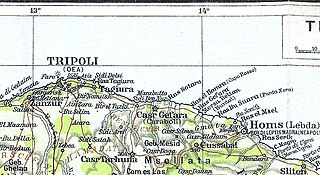
Tajura, also spelt Tajoura, is a town in north-western Libya, and baladiyah in the Tripoli Muhafazah, on the Mediterranean coast 23 kilometres (14 mi) east of Tripoli.
Castelverde, also named Gasr Garabulli, is a town in the Tripoli District (Tarabulus), of the Tripolitania region in northwestern Libya.
A health care crisis currently exists in Libya due to the ongoing conflict.
Janzur or Janzour, also known as Zanzur, is a city in north-western Libya, situated on the Libyan coastline of the Mediterranean Sea, located in the west of the capital Tripoli, and East of Az-Zawiya. Residents of this city are called Janazrah.

Switzer Canyon is a canyon in San Diego, California. It is situated to the east of Balboa Park and serves as the boundary between the neighborhoods of North Park and South Park in Central San Diego. Switzer Canyon remains an oasis of natural vegetation between some of the city's most urban neighborhoods and is a prime example of San Diego county's unique canyon-laced topography.
Tripoli Zoo is a zoological garden and botanical garden in Tripoli, Libya. Located south of Tripoli's city center adjacent to Tarabulus Zoo Park, it is a large reserve of plants, trees and open green spaces and is the country's biggest zoo.
AlMaya It is a coastal area located in the northwest of Libya, about 27 km west of the capital Tripoli , Almaya follows Maamoura, Tina, Qaraqouzah and Tuwaybiyah. Almaya forms a municipality. [1] [2] The Al Mayah region is bounded by the Mediterranean Sea to the north and Janzour. in the east, and Al-Zawiya in the west, and Al-Zahra in the south

The Royal Palace was the residence of the Libyan monarch in the capital city, Tripoli.

The Red Castle, in Arabic As-saraya Al-hamra, sometimes also Red Fort or Red Saraya, is a major landmark on the waterfront of Tripoli, bordering Martyrs' Square. It has been the home of the Red Castle Museum since 1919, and of the Libyan Department of Archaeology since 1952.
References
Coordinates: 32°51′44″N13°11′13″E / 32.8621°N 13.1870°E
| | This Libya location article is a stub. You can help Wikipedia by expanding it. |