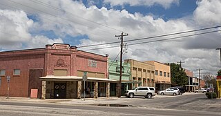
Teague, Texas, was initially settled around the time of the Civil War and developed significantly during the latter half of the 19th century. Originally known as Brewer, the community grew as a small settlement. In April 1886, a resident wrote that all they needed was a jeweler and shoemaker. The resident went on to inventory all the businesses they had, such as a good dry goods and grocery store, a blacksmith and wood shop, and a barber. Later in 1886, a gin was to open. The 1895 Rand McNally atlas shows Brewer with a post office and no express office or railroad. Also in 1895, Brewer Baptist Church ministered by A. B. Tedder had 109 members.The arrival of the Trinity and Brazos Valley Railway in 1906 was pivotal for Teague's development. The railway company established its machine and car shops in the town, which led to rapid growth and the town being renamed Teague. This renaming was done by the railway magnate Benjamin Franklin Yoakum in honor of his mother, Narcissus Teague, and her parents, who were early pioneers in Freestone County. Teague was incorporated as a municipality in 1906 and officially recognized as a city in 1907.[5][6]
In its early years, Teague thrived as a significant railway hub and a shipping center for local cotton farmers. By 1914, the town had a diverse array of services and amenities, including multiple churches, public schools, waterworks, an electric light plant, an ice plant, banks, cotton gins, a cottonseed oil mill, a cotton compress, and several newspapers. The population reached approximately 3,300 by that time. However, the Great Depression and subsequent economic challenges led to a decline in the number of businesses and population. Despite these hardships, Teague's population saw steady growth from the mid-1980s onwards, with the community adapting and evolving through various economic shifts, including the rise of natural gas production as an important industry.[7]
Teague also has a 3300-foot-long airport used primarily for recreational use.[8]
In recent years, Teague has seen a variety of community events and developments that highlight its vibrant local culture and civic engagement. Recently, the town hosted numerous events, including holiday celebrations, fairs, and educational workshops. The Fourth of July festivities included a fireworks show and community picnics, while the annual Peach Festival in Fairfield featured music, food trucks, and a 5K run [9]. The Teague Public Library has also been active, offering programs like arts and crafts classes, science days, and a real Mad Hatter Bubble Show.
On the civic front, Teague has continued to maintain its community-oriented focus through various public services and development projects. The city has seen active participation in local government elections, with positions such as mayor and aldermen being regularly contested [10]. Additionally, the Teague Economic Development Corporation has been involved in promoting local business growth and infrastructure improvements. The town's public facilities, such as the Teague City Lake and the BRI Museum, provide recreational and educational opportunities for residents and visitors alike. These events and initiatives demonstrate Teague's ongoing commitment to fostering a strong, connected community.
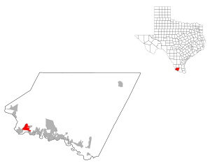
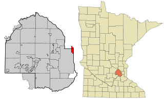
According to the United States Census Bureau, the city of Teague has a total area of 5.3 square miles (13.6km2), of which 5.1 square miles (13.1km2) is land and 0.2 square miles (0.5km2), or 3.69%, is water.[4]
As of the 2020 United States census, there were 3,384 people, 1,088 households, and 802 families residing in the city.
As of the census[2] of 2000, there were 4,557 people, 1,275 households, and 864 families residing in the city. The population density was 1,325.4 inhabitants per square mile (511.7/km2). There were 1,526 housing units at an average density of 443.9 per square mile (171.4/km2). The racial makeup of the city was 65.28% White, 27.67% African American, 0.13% Native American, 0.20% Asian, 0.07% Pacific Islander, 6.03% from other races, and 0.61% from two or more races. Hispanic or Latino of any race were 13.50% of the population.
There were 1,275 households, out of which 32.5% had children under the age of 18 living with them, 49.6% were married couples living together, 14.6% had a female householder with no husband present, and 32.2% were non-families. 29.8% of all households were made up of individuals, and 17.3% had someone living alone who was 65 years of age or older. The average household size was 2.51 and the average family size was 3.11.
In the city, the population was spread out, with 19.9% under the age of 18, 14.6% from 18 to 24, 36.9% from 25 to 44, 15.4% from 45 to 64, and 13.2% who were 65 years of age or older. The median age was 31 years. For every 100 females, there were 166.0 males. For every 100 females age 18 and over, there were 185.0 males.
The median income for a household in the city was $29,485, and the median income for a family was $36,842. Males had a median income of $24,884 versus $18,821 for females. The per capita income for the city was $14,326. About 10.0% of families and 16.3% of the population were below the poverty line, including 22.9% of those under age 18 and 14.5% of those age 65 or over.
Education
The city, and surrounding areas, are served by the Teague Independent School District, providing education from pre-kindergarten through 12th grade. The district includes Teague Elementary School, Teague Junior High School, and Teague High School, each dedicated to fostering a supportive and enriching educational environment. Teague ISD has a strong emphasis on academic achievement, extracurricular involvement, and community engagement. Recent initiatives include the District of Innovation Plan, which aims to provide more flexibility and local control over educational practices to better meet the needs of students and staff.
In recent years, Teague ISD has focused on enhancing its facilities and resources to support student success. The district offers a variety of extracurricular activities, including athletics, band, theater, and Future Farmers of America (FFA). These programs aim to develop well-rounded students with opportunities for leadership and personal growth. The district has also prioritized health and nutrition, special education, and technology integration to ensure a comprehensive and inclusive educational experience. Community involvement remains a cornerstone of Teague ISD's philosophy, with numerous events and programs designed to foster strong relationships between the schools and the broader community.
As of the 2021-2022 school year, it had 1,181 students. 48.8% of students were considered at risk of dropping out of school. 10% of students were enrolled in bilingual and English language learning programs.[16]
The school received an accountability rating of A for the 2021-2022 school year.[17]
In the Class of 2021, 97.3% of students received their high school diplomas on time or earlier. The dropout rate for students in grades 9-12 was 0.2% during the 2020-2021 school year.[18]
As of the 2021-2022 school year, an average teacher's salary was $53,708, which is $5,179 less than the state average. On average, teachers had 13.1 years of experience.[20]
Related Research Articles
Kenton County is a county located in the northern part of the Commonwealth of Kentucky. As of the 2020 census, the population was 169,064, making it the third most populous county in Kentucky. Its county seats are Covington and Independence. It was, until November 24, 2010, the only county in Kentucky to have two legally recognized county seats. The county was formed in 1840 and is named for Simon Kenton, a frontiersman notable in the early history of the state.
Plymouth is a city in Hennepin County in the U.S. state of Minnesota. A suburb in the Minneapolis–Saint Paul metropolitan area, the city is about 10 miles (16 km) west of downtown Minneapolis. The population was 81,026 at the 2020 census, making it Minnesota's 7th-largest city.
Murphy is a city in suburban Collin County, Texas, United States. The 2020 census reported the population as 21,013 compared to 3,099 in 2000. Murphy is located northeast of Dallas and has a history that goes back to the late 1800s.
Shady Shores is a town in Denton County, Texas, United States. The population was 2,764 at the 2020 census. It is also one of four communities in the Lake Cities.
Fairfield is a city and county seat of Freestone County, Texas, United States. The population was 2,850 at the 2020 census, down from 3,094 at the 2000 census. It was founded in 1851.
Wortham is a town in Freestone County, Texas, United States. The population was 980 at the 2020 census.
La Marque is a city in Galveston County, Texas, United States, south of Houston. The city population in 2020 was 18,030. La Marque experienced considerable growth in the 1950s, during which the city provided a general administrative and trades and crafts workforce helping to support the petrochemical complex in adjoining Texas City. It is the hometown of U.S. Senator Kay Bailey Hutchison and Norman Bulaich.
Malakoff is a city in Henderson County, Texas, United States. The population was 2,179 at the 2020 census. The city is named after a Russian fort of Malakoff, which played a pivotal role during the siege of Sevastopol during the Crimean War.
Alton is a city in Hidalgo County, Texas, United States. The population was 18,198 at the 2020 census.
La Villa is a city in Hidalgo County, Texas, United States. The population was 2,804 at the 2020 United States Census. It is part of the McAllen–Edinburg–Mission and Reynosa–McAllen metropolitan areas.
Palmhurst is a city in Hidalgo County, Texas, United States. The population was 2,607 at the 2010 United States Census. It is part of the McAllen–Edinburg–Mission and Reynosa–McAllen metropolitan areas.
Crandall is a city in Kaufman County, Texas, United States. Its population was 5,100 in 2023. It began as a railway town, developing alongside the Texas Trunk Railroad in the early 1880s. Crandall is named after Cornelius F. Crandall, who had previously founded Crandall, Indiana
Pinehurst is a census-designated place (CDP) in Montgomery County, Texas, United States. The population was 5,195 at the 2020 census.
Vega is a city and county seat of Oldham County, Texas, United States. The population was 884 at the 2010 census, down from 936 at the 2000 census.
Escobares is a city in Starr County, Texas, United States. The population was 2,588 at the 2020 census. The city was formed in 2005 from part of the deleted Escobares CDP, and parts of Garceno, and North Escobares CDPs, and additional area. Prior to its 2005 incorporation as a city, it was a census-designated place (CDP). The population of the CDP was 1,954 at the 2000 census.
Roma Creek is a former census-designated place (CDP) in Starr County, Texas, United States. The population was 350 at the 2010 census down from 610 at the 2000 census.
Mirando City is a census-designated place (CDP) in Webb County, Texas, United States. It is approximately 30 miles east of Laredo and 130 miles southwest of Corpus Christi. The population was 166 at the 2010 census. The town gets its name from Nicolás Mirando, a Spanish land grantee. The population of Mirando City was highest in 1929, at an estimated 1500.
Poth is a town in Wilson County, Texas, United States. The population was 1,819 at the 2020 census. It is part of the San Antonio metropolitan area.
Teague Independent School District is a public school district based in Teague, Texas, United States. The school received an accountability rating of A for the 2021-2022 school year by the Texas Education Agency.
St. Anthony, also known as Saint Anthony Village, is a city in Hennepin and Ramsey counties in the U.S. state of Minnesota. The population was 9,257 at the 2020 census, of whom 5,621 lived in the larger Hennepin County part of the city and 3,654 in the Ramsey County part. The city is run by a five-member council consisting of a mayor and four council members who serve four-year terms.
↑ Note: the US Census treats Hispanic/Latino as an ethnic category. This table excludes Latinos from the racial categories and assigns them to a separate category. Hispanics/Latinos can be of any race.[14][15]
This page is based on this Wikipedia article Text is available under the CC BY-SA 4.0 license; additional terms may apply. Images, videos and audio are available under their respective licenses.