Related Research Articles

The Savu Sea is a small sea within Indonesia named for the island of Savu (Sawu) on its southern boundary. It is bounded by Savu and Rai Jua to the south, the islands of Rote and Timor to the east, Flores and the Alor archipelago to the north/northwest, and the island of Sumba to the west/northwest. Between these islands, it flows into the Indian Ocean to the south and west, the Flores Sea to the north, and the Banda Sea to the northeast.
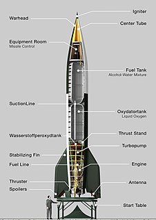
A short-range ballistic missile (SRBM) is a ballistic missile with a range of about 1,000 kilometres (620 mi) or less. In past and potential regional conflicts, these missiles have been and would be used because of the short distances between some countries and their relative low cost and ease of configuration. In modern terminology, SRBMs are part of the wider grouping of theatre ballistic missiles, which includes any ballistic missile with a range of less than 3,500 km.

The Ellen Glacier is a glacier in the central Sentinel Range of the Ellsworth Mountains of Antarctica. It drains the eastern slopes of Mount Anderson and Long Gables and flows generally southeast for 22 nautical miles to Barnes Ridge, where it leaves the range and enters the south flowing Rutford Ice Stream.
Oates Land is a region of Antarctica. It is variously defined as a portion of the East Antarctica near the coast stretching along and inland from the Oates Coast and as an officially delineated wedge-shaped segment of the Australian Antarctic Territory. The segment of the Australian claim extends between 153°45' E and 160° E, forming a wedge between Latitude 60° S and the South Pole. It is bounded in the east by the Ross Dependency and overlaps George V Land to the west.

The Lower Himalayan Range – also called the Inner Himalayas or Lesser Himalayas or Himachal – is a major east–west mountain range with elevations 3,700 to 4,500 m along the crest, paralleling the much higher High Himalayas range from the Indus River in Pakistan across northern India, Nepal and Bhutan but then the two ranges become increasingly difficult to differentiate east of Bhutan as the ranges approach the Brahmaputra River. The Himachal range also parallels the lower Shiwalik or Churia Range to the south. The Pir Panjal is the largest range of the Lesser Himalayas.
The Western Coastal Plains is a strip of coastal plain 50 kilometres in width between the west coast of India and the Western Ghats hills, which starts near the south of the Tapi River. The plains are located between the Western Ghats and the Arabian Sea. The plains begin at Gujarat in the north and end at Tamil Nadu in the south. It includes the states of Gujarat, Maharashtra, Goa, Karnataka, Kerala, and Tamil Nadu. The region consists of three sections: the Northern part of the coast is called the Konkan, the central stretch is called the Kanara or the "Karavali", while the southern stretch is referred to as the Malabar Coast. On its northern side there are two gulfs: the Gulf of Khambat and the Gulf of Kutch. The rivers along the coast form estuaries and provide conditions ideal for pisciculture. Because of the presence of less coastal land in this part, it will be affected more by the global warming.

Mariner Glacier is a major glacier over 100 km (62 mi) long, descending southeast from the plateau of Victoria Land, between Mountaineer Range and Malta Plateau, and terminating at Lady Newnes Bay, Ross Sea, where it forms the floating Mariner Glacier Tongue. Its lower reaches and entrance to its valley were reconnoitered in December 1958 by Captain John Cadwalader, US Navy, and two members of New Zealand Geological Survey Antarctic Expedition (NZGSAE), in a flight from the icebreakers USS Glacier and USS Staten Island which were lying close off the south end of Coulman Island, in an attempt to land expedition members on the mainland. Named by NZGSAE, 1958–59, as a tribute to the work of mariners in Antarctic research and exploration.
Zeller Glacier is a glacier about 10 miles (16 km) long, flowing west-northwest to enter the south side of Byrd Glacier just north of Mount Fries. Named by the Advisory Committee on Antarctic Names (US-ACAN) for Edward J. Zeller, geologist at McMurdo Station, 1959–60 and 1960-61 seasons.
Poulter Glacier is a glacier in Antarctica, about 180 miles from the South Pole at an elevation of 8,000 feet. It flows east from the Antarctic Plateau past the Rawson Mountains in the Queen Maud Mountains and joins with the Scott Glacier. It was discovered by the Byrd Antarctic Expedition II Geology Party under Quinn Blackburn. It was named by Admiral Richard Byrd for Thomas Poulter.
Scott Coast is the portion of the coast of Victoria Land between Cape Washington and Minna Bluff. Named by New Zealand Antarctic Place-Names Committee (NZ-APC) in 1961 after Captain Robert Falcon Scott, Royal Navy, leader of the Discovery expedition (1901–1904) and the British Antarctic Expedition (1910-1913), who lost his life on the return journey from the South Pole. Much of the early exploration of this coastline was accomplished by Scott and his colleagues, and many of the names in the region were bestowed by him.
Dawson River, a perennial river of the Manning River catchment, is located in the Mid North Coast district of New South Wales, Australia.
Glen Fernaigh River, a perennial river of the Clarence River catchment, is located in the Northern Rivers region of New South Wales, Australia.
Moppy River, a perennial river of the Manning River catchment, is located in the Upper Hunter district of New South Wales, Australia.
Argo Glacier is a glacier in the Miller Range, 10 nautical miles (19 km) long, flowing northeast to enter Marsh Glacier just south of Macdonald Bluffs. It was named by the New Zealand Geological Survey Antarctic Expedition (1961–62) after the Argo, the vessel sailed by Jason in Greek mythology.
Armstrong Glacier is a glacier flowing from the south side of Mount Bagshawe westward into George VI Sound. It provides the only known safe route for mechanical vehicles from George VI Sound to the Palmer Land plateau. It was named by the United Kingdom Antarctic Place-Names Committee for Edward B. Armstrong, British Antarctic Survey surveyor at Stonington Island, 1964–65.
Barnett Glacier is a large glacier in the Anare Mountains that flows east along the south side of Tapsell Foreland into Smith Inlet, northern Victoria Land, Antarctica. It was mapped by the United States Geological Survey (USGS) from surveys and from U.S. Navy air photos, 1960–63, and named by the Advisory Committee on Antarctic Names after Donald C. Barnett, USGS topographic engineer, a member of USGS Topo East and West, 1962–63, in which the expedition extended geodetic control from the area of Cape Hallett to the Wilson Hills and from the foot of Beardmore Glacier through the Horlick Mountains. The glacier lies on the Pennell Coast, a portion of Antarctica lying between Cape Williams and Cape Adare.

Koch Glacier is a glacier 3 nautical miles (6 km) long immediately east of Jenner Glacier on the south side of Brabant Island, in the Palmer Archipelago, Antarctica. It drains the south slopes of Solvay Mountains and flows south-southwestwards into Chiriguano Bay southeast of Paprat Peak.
The Beaury Creek, a perennial stream of the Clarence River catchment, is located in the Northern Rivers region of New South Wales, Australia.
The Boundary Creek, a perennial stream of the Clarence River catchment, is located in the Northern Rivers region of New South Wales, Australia.
The Erskine Creek, a perennial stream of the Hawkesbury-Nepean catchment, is located in the Blue Mountains region of New South Wales, Australia.
References
| | This article related to telephone numbers is a stub. You can help Wikipedia by expanding it. |
| | This South Georgia and the South Sandwich Islands article is a stub. You can help Wikipedia by expanding it. |