
Big Bend National Park is an American national park located in West Texas, bordering Mexico. The park has national significance as the largest protected area of Chihuahuan Desert topography and ecology in the United States, and was named after a large bend in the Rio Grande/Río Bravo. The park protects more than 1,200 species of plants, more than 450 species of birds, 56 species of reptiles, and 75 species of mammals. Additional park activities include scenic drives, programs led by Big Bend park rangers, and stargazing.

Anza-Borrego Desert State Park is a California State Park located within the Colorado Desert of southern California, United States. The park takes its name from 18th century Spanish explorer Juan Bautista de Anza and borrego, a Spanish word for sheep. With 585,930 acres (237,120 ha) that includes one-fifth of San Diego County, it is the largest state park in California.

The Sevier River is a 400-mile (640 km)-long river in the Great Basin of southwestern Utah in the United States. Originating west of Bryce Canyon National Park, the river flows north through a chain of high farming valleys and steep canyons along the west side of the Sevier Plateau before turning southwest and terminating in the endorheic basin of Sevier Lake in the Sevier Desert. It is used extensively for irrigation along its course, with the consequence that Sevier Lake is usually dry.

The Santa Ana Mountains are a short peninsular mountain range along the coast of Southern California in the United States. They extend for approximately 61 miles (98 km) southeast of the Los Angeles Basin largely along the border between Orange and Riverside counties.

The San Bernardino Mountains are a high and rugged mountain range in Southern California in the United States. Situated north and northeast of San Bernardino and spanning two California counties, the range tops out at 11,503 feet (3,506 m) at San Gorgonio Mountain – the tallest peak in Southern California. The San Bernardinos form a significant region of wilderness and are popular for hiking and skiing.

The Santa Rosa Mountains are a short mountain range in the Peninsular Ranges system, located east of the Los Angeles Basin and northeast of the San Diego metropolitan area of southern California, in the southwestern United States.

State Route 74, part of which forms the Palms to Pines Scenic Byway or Pines to Palms Highway, and the Ortega Highway, is a state highway in the U.S. state of California. It runs from Interstate 5 in San Juan Capistrano in Orange County to the city limits of Palm Desert in Riverside County. Stretching about 111 miles (179 km), it passes through several parks and National Forests between the Pacific coast and the Coachella Valley.
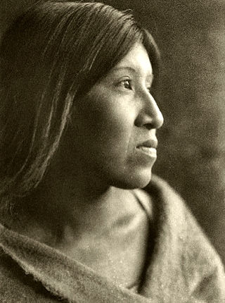
The Cahuilla, also known as ʔívil̃uqaletem or Ivilyuqaletem, are a Native American people of the various tribes of the Cahuilla Nation, living in the inland areas of southern California. Their original territory included an area of about 2,400 square miles (6,200 km2). The traditional Cahuilla territory was near the geographic center of Southern California. It was bounded to the north by the San Bernardino Mountains, to the south by Borrego Springs and the Chocolate Mountains, to the east by the Colorado Desert, and to the west by the San Jacinto Plain and the eastern slopes of the Palomar Mountains.

The Cleveland National Forest encompasses 460,000 acres/720 sq mi (1,900 km2) of inland montane regions—approx. 60 miles from the Pacific Ocean—within the counties of San Diego, Riverside, and Orange, California. The landscape varies somewhat, with mostly chaparral canyons, arroyos and high desert, but dotted with meadows and oak and conifer forests. Near water sources, riparian environments and perennial aquatic plants attract native and migratory wildlife, such as at San Diego’s man-made Lake Cuyamaca. A generally warm and dry, inland-Mediterranean climate prevails over the forest, with the cooler months producing morning frost and snowfall. It is the southernmost U.S. National Forest of California. The area is administered by the U.S. Forest Service, a government agency within the United States Department of Agriculture, and is locally overseen by the Descanso, Palomar and Trabuco Ranger Districts.
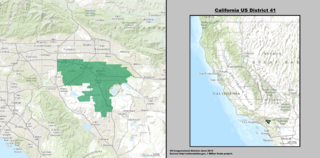
California's 41st congressional district is a congressional district in Riverside County, in the U.S. state of California. The district is currently represented by Republican Ken Calvert.

Big Bend Ranch State Park is a 311,000-acre (126,000 ha) state park located on the Rio Grande in Brewster and Presidio counties, Texas. It is the largest state park in Texas. The closest major town is Presidio, Texas. The state park's head office is located in Lajitas, Texas at the Barton Warnock Visitor Center. It includes Colorado Canyon.

The following outline is provided as an overview of and topical guide to the U.S. state of California.

The Santa Rosa Wilderness is a 72,259-acre (292.42 km2) wilderness area in Southern California, in the Santa Rosa Mountains of Riverside and San Diego counties, California. It is in the Colorado Desert section of the Sonoran Desert, above the Coachella Valley and Lower Colorado River Valley regions in a Peninsular Range, between La Quinta to the north and Anza Borrego Desert State Park to the south. The United States Congress established the wilderness in 1984 with the passage of the California Wilderness Act, managed by both the US Forest Service and the Bureau of Land Management. In 2009, the Omnibus Public Land Management Act was signed into law which added more than 2,000 acres (8.1 km2). Most of the Santa Rosa Wilderness is within the Santa Rosa and San Jacinto Mountains National Monument.

San Mateo Creek is a stream in Southern California in the United States, whose watershed mostly straddles the border of Orange and San Diego Counties. It is about 22 miles (35 km) long, flowing in a generally southwesterly direction. Draining a broad valley bounded by the Santa Ana Mountains and Santa Margarita Mountains, San Mateo Creek is notable for being one of the last unchannelized streams in Southern California.

De Luz is an unincorporated community in San Diego County, California. De Luz is 6 miles (9.7 km) northwest of Fallbrook and due west of Temecula. The region is approximately 12 miles (19 km) east of the Pacific Ocean and lies at the southern end of the Santa Ana Mountains.

Tahquitz Canyon is located in Palm Springs, California on a section of the Agua Caliente Indian Reservation. The canyon descends from the Riverside County San Jacinto Mountains. It was continually inhabited for at least 5,000 years by the Native American Cahuilla people, and is one of many canyons of cultural significance to the Cahuilla. Today it is a nature preserve open to the public that is overseen by the Agua Caliente Band of Cahuilla Indians.
The Philip L. Boyd Deep Canyon Desert Research Center is one of the original seven of the total 39 sites in the University of California Natural Reserve System. It contains lands originally donated to the University by regent Philip L. Boyd in 1958. The Research Center is contained within UNESCO's Mojave and Colorado Deserts Biosphere Reserve.
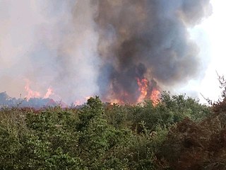
The Tenaja Fire was a wildfire in the rural community of La Cresta southwest of Murrieta in Riverside County, California, United States, located 80 miles from Los Angeles. The fire broke out on Wednesday, September 4, 2019 and ballooned to 1,926 acres (8 km2) over the course of two days. The blaze, dubbed the Tenaja fire after igniting along Tenaja Road and Clinton Keith Road in La Cresta, forced the evacuation of over 1,200 people and lead to the closure of multiple school districts in the Murrieta, Perris and Lake Elsinore area due to the poor air quality. The exact cause of the fire remains under investigation although several sources cited the possibility of lightning being the direct cause. Two structures were damaged as a result of the fire and one firefighter suffered minor injuries. The fire was contained on September 14 and had burned 1,926 acres (779 ha).


