Tendring District

Last updated

Tendring District
Clacton-on-Sea.jpg
Clacton-on-Sea, the administrative centre of the district
Motto(s): 
Latin: Pro Bono Omnium, lit. 'For the good of all'
Tendring UK locator map.svg
Tendring shown within Essex
Coordinates: 51°47′N1°08′E / 51.783°N 1.133°E / 51.783; 1.133
Sovereign state United Kingdom
Country England
Region East of England
Non-metropolitan county Essex
Incorporated 1 April 1974
Named for Tendring Hundred
Administrative HQ Clacton-on-Sea
Government
[1]
  Type Non-metropolitan district
  BodyTendring District Council
   Executive Leader and cabinet
   Control No overall control
   Leader Mark Stephenson (Ind.)
  ChairDan Casey
   MPs
Area
[2]
  Total141 sq mi (366 km2)
  Land130 sq mi (336 km2)
  Rank 110th
Population
 (2022) [3]
  Total151,451
  Rank 145th
  Density1,200/sq mi (450/km2)
Ethnicity (2021)
[4]
   Ethnic groups
List
Religion (2021)
[4]
   Religion
List
Time zone UTC+0 (GMT)
  Summer (DST) UTC+1 (BST)
Postcode areas
CO
Dialling codes 01255
GSS code E07000076
Website tendringdc.gov.uk
Tendring District Council
Tendring District Council logo.svg
Type
Type
Leadership
Dan Casey,
Independent
since 30 April 2024 [5]
Mark Stephenson,
Independent
since 23 May 2023
Ian Davidson
since 1 December 2010 [6]
Structure
Seats48 councillors
Political groups
Administration (28)
  Independent (16)
  Labour (7)
  Liberal Democrats (4)
  Tendring First (1)
Other parties (20)
  Conservative (15)
  Independent (5)
Elections
First-past-the-post
Last election
4 May 2023
Next election
6 May 2027
Meeting place
Clacton-on-Sea- Clacton Town Hall (geograph 5966342).jpg
Town Hall, Station Road, Clacton-on-Sea, Essex, CO15 1SE
Website
www.tendringdc.gov.uk

Tendring District is a local government district in north-east Essex, England. Its council is based in Clacton-on-Sea, the largest town. Other towns are Brightlingsea, Harwich, Frinton-on-Sea and Walton-on-the-Naze.

Contents

The district borders the City of Colchester to the west and the Babergh District of Suffolk, across the estuary of the River Stour, to the north. To the east and south, it faces the North Sea, with the estuary of the River Colne to the south-west. The area is sometimes referred to as the Tendring Peninsula.

The modern local government district was formed in 1974. The name Tendring comes from the ancient Tendring Hundred which was named after the small village of Tendring.

History

Harwich, an important port town in both the district and Essex Harwich England.jpg
Harwich, an important port town in both the district and Essex

The district was formed on 1 April 1974 under the Local Government Act 1972, covering the whole area of five former districts, which were all abolished at the same time: [7]

The new district was named Tendring after the ancient Tendring Hundred, which was in turn named after the small village of Tendring at the centre of the area. [8]

The 1086 Domesday Book records the name as Tenderinga and in 1242 the Pipe Rolls mention it as Terring. [9]

The Tendring Poor Law Union, established in 1835, had covered the same area as the present district. [10]

During the English Civil War, the self-appointed Witchfinder General Matthew Hopkins carried out many trials throughout this and the surrounding area, especially in the town of Manningtree and village of Mistley on the River Stour.

Governance

Tendring District Council provides district-level services. County-level services are provided by Essex County Council. Much of the district is also covered by civil parishes, which form a third tier of local government. [11]

Political control

The council has been under no overall control since the 2023 election, being led by a coalition of independent councillors, Labour and the Liberal Democrats. [12]

The first election to the council was held in 1973, initially operating as a shadow authority alongside the outgoing authorities until the new arrangements came into effect on 1 April 1974. Political control of the council since 1974 has been as follows: [13] [14]

Party in controlYears
Conservative 1974–1991
No overall control 1991–1995
Labour 1995–1999
No overall control 1999–2011
Conservative 2011–2015
No overall control 2015–present

Leadership

The leaders of the council since 2009 have been: [15]

CouncillorPartyFromTo
Neil Stock [16] Conservative 200927 Nov 2012
Peter Halliday [17] Conservative 27 Nov 201213 Dec 2013
Mick Page Conservative 11 Feb 201410 May 2015
Neil Stock Conservative 26 May 20157 May 2023
Mark Stephenson Independent 23 May 2023

Composition

Since the last boundary changes in 2019 there have been 48 councillors representing 32 wards, with each ward electing one, two or three councillors. Elections are held every four years. [18]

Following the 2023 election, a by-election in January 2024 and changes of allegiance up to February 2024, the composition of the council was: [19]

PartyCouncillors
Independent 21
Conservative 15
Labour 7
Liberal Democrats 4
Tendring First 1
Total48

Of the independent councillors, eleven sit with the Tendring First councillor as the "Tendring Independents" group, five sit as the "Independent Group", three form the "Tendring Residents' Alliance" and two do not belong to any group. The council's administration is a coalition of the Tendring Independents, the Independent Group, Labour and the Liberal Democrats. [20] The next election is due in 2027.

Premises

The council has its main offices and meeting place at Clacton Town Hall on Station Road. The building had been built for the former Clacton Urban District Council in 1931. [21]

Geography

Walton-on-the-Naze, one of the many coastal settlements in the district Walton-on-the-Naze.jpg
Walton-on-the-Naze, one of the many coastal settlements in the district

The highest part of the district is a low (115'; 35 metres) ridge running west to east only 2 miles (3 km) south of the River Stour. The greater part of the district is undulating land sloping very gently to the south which is traversed by a number of streams.

In the extreme east of the district is an area formerly known as the Soken which was granted special privileges in Saxon times. It is remembered in the place names Kirby-le-Soken, Thorpe-le-Soken and Walton-le-Soken (an older name for Walton-on-the-Naze).

Demography

Jaywick, a shanty settlement on the coast near Clacton Jaywick Sands - geograph.org.uk - 538562.jpg
Jaywick, a shanty settlement on the coast near Clacton

Tendring district contains the most deprived part of England, in the Jaywick area. This area was ranked as the most deprived are in the government's indices of deprivation in 2010, 2015 and 2019 (being the most recent survey as at 2022). [22]

Media

In terms of television, the district is served by BBC East and ITV Anglia with television signals received from the Sudbury TV transmitter. [23]

Radio stations for the area are:

Local newspapers are the Colchester Gazette and Essex County Standard .

Parishes

There are 27 civil parishes in the district. The former Clacton Urban District is an unparished area. [24] The parish councils of Brightlingsea, Frinton and Walton, Harwich, and Manningtree take the style "town council". [25]

Arms

Coat of arms of Tendring District
Crest
On a wreath of the colours an ancient ship Gules sail furled Proper flying flags and forked pennon of St. George and charged on the hull with three escallops Or pendent from the yardarm by chains a portcullis Or nailed and spiked Azure.
Escutcheon
Azure on a fess between two chevrons Argent a mural crown Gules all between two flaunches Argent each charged with two bars wavy Azure surmounted of a seaxe point upwards Proper hilt and pommel Or.
Motto
Pro Bono Omnium (For The Good of All) [26]
Badge
On a roundel Azure fimbriated Argent and environed of a wreath of laurel Or a tau cross Argent.

Related Research Articles

<span class="mw-page-title-main">Clacton-on-Sea</span> Seaside town in Essex, England

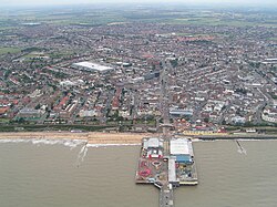
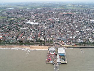
Clacton-on-Sea, often simply called Clacton, is a seaside town and resort in the county of Essex, on the east coast of England. It is located on the Tendring Peninsula and is the largest settlement in the Tendring District, with a population of 53,200 (2021). The town is situated around 77 miles north-east of Central London, 40 miles east-north-east of Chelmsford, 58 miles north-east of Southend-on-Sea, 16 miles south-east of Colchester and 16 miles south of Harwich.

<span class="mw-page-title-main">Walton-on-the-Naze</span> Coastal town in Essex, England

Walton-on-the-Naze is a seaside town on the North Sea coast. It is part of the parish of Frinton and Walton, in the Tendring district in Essex, England. The town is located north of Clacton and south of the port of Harwich; Frinton-on-Sea lies to the south of the town. The town has a population of 12,054, according to the 2011 census; in 1931, the parish had a population of 3,071. The town attracts many visitors; The Naze and the pier are the main attractions.

<span class="mw-page-title-main">Manningtree</span> Town and civil parish in Essex, England

Manningtree is a town and civil parish in the Tendring district of Essex, England, which lies on the River Stour. It is part of the Suffolk Coast and Heaths Area of Outstanding Natural Beauty.

<span class="mw-page-title-main">Thorpe-le-Soken</span> Village in Essex, England

Thorpe-le-Soken is a village and civil parish in the Tendring district of Essex, England. It is located east of Colchester, west of Walton-on-the-Naze and Frinton-on-Sea, and north of Clacton-on-Sea.

<span class="mw-page-title-main">North Essex (UK Parliament constituency)</span> Parliamentary constituency in the United Kingdom, 1832-1868 & 1997–2010

North Essex was a parliamentary constituency represented in the House of Commons of the Parliament of the United Kingdom between 1997 and 2010. It elected one Member of Parliament (MP) by the first past the post system of election.

<span class="mw-page-title-main">Harwich (UK Parliament constituency)</span> Parliamentary constituency in the United Kingdom, 1801–2010

Harwich was a parliamentary constituency represented in the House of Commons of the Parliament of the United Kingdom until its abolition for the 2010 general election.

<span class="mw-page-title-main">Sunshine Coast Line</span>

The Sunshine Coast Line is the current marketing name of what originally was the Tendring Hundred Railway Line, a branch off the Great Eastern Main Line in the East of England. It links Colchester to the seaside resorts of Clacton-on-Sea and, via a branch, Walton-on-the-Naze. The line is part of the Network Rail Strategic Route 7, SRS 07.08, and is classified as a London & South East commuter line. Passenger services on the line are currently operated by Greater Anglia.

<span class="mw-page-title-main">Clacton (UK Parliament constituency)</span> Parliamentary constituency in the United Kingdom, 2010 onwards

Clacton is a constituency in Essex represented in the British House of Commons since 2017 by Giles Watling of the Conservative Party.

<span class="mw-page-title-main">Harwich and North Essex (UK Parliament constituency)</span> Parliamentary constituency in the United Kingdom, 2010 onwards

Harwich and North Essex is a constituency represented in the House of Commons of the UK Parliament by Bernard Jenkin of the Conservative Party since its creation in 2010.

<span class="mw-page-title-main">Mistley</span> Human settlement in England

Mistley is a village and civil parish in the Tendring district of northeast Essex, England. It is around 11 miles northeast of Colchester and is east of, and almost contiguous with, Manningtree. The parish consists of Mistley and New Mistley, both lying beside the Stour Estuary, and Mistley Heath, about a mile to the south. The village is in the parliamentary constituency of Harwich and North Essex. The village has its own parish council.

<span class="mw-page-title-main">Wivenhoe railway station</span> Railway station in Essex, England

Wivenhoe railway station is on the Sunshine Coast Line, a branch of the Great Eastern Main Line, in the East of England, serving the small town of Wivenhoe, Essex. It is 56 miles (90 km) down the line from London Liverpool Street and is situated between Hythe to the west and Alresford to the east. Its three-letter station code is WIV.

<span class="mw-page-title-main">Frinton-on-Sea railway station</span> Railway station in Essex, England

Frinton-on-Sea railway station is on the Walton branch of the Sunshine Coast Line in the East of England, serving the seaside town of Frinton-on-Sea, Essex. It is 68 miles 66 chains (110.8 km) down the line from London Liverpool Street and is situated between Kirby Cross to the west and Walton-on-the-Naze to the east. Its three-letter station code is FRI.

<span class="mw-page-title-main">Walton-on-the-Naze railway station</span> Railway station in Essex, England

Walton-on-the-Naze railway station is one of the two eastern termini of the Sunshine Coast Line, a branch of the Great Eastern Main Line, in the East of England. It serves the seaside town of Walton-on-the-Naze, Essex. It is 70 miles 15 chains (113.0 km) down the line from London Liverpool Street. Its three-letter station code is WON. The preceding station on the line is Frinton-on-Sea.

<span class="mw-page-title-main">Colchester North (UK Parliament constituency)</span> Parliamentary constituency in the United Kingdom, 1983–1997

North Colchester was a Borough Constituency in Essex, represented in the House of Commons of the Parliament of the United Kingdom from 1983 until 1997. It elected one Member of Parliament (MP) by the first past the post system of election.

Tendring Technology College is a secondary school with Sixth Form College located in Essex, England. It is one of the six secondary schools in the Tendring district, along with Clacton Coastal Academy, Clacton County High School, Colne, Manningtree High School and the Harwich and Dovercourt High School.

<span class="mw-page-title-main">2013 Essex County Council election</span> 2013 UK local government election

An election to Essex County Council took place on 2 May 2013 as part of the 2013 United Kingdom local elections. 75 councillors were elected from 70 electoral divisions, which returned either one or two county councillors each by first-past-the-post voting for a four-year term of office. The electoral divisions were the same as those used at the previous election in 2009. No elections were held in Thurrock or Southend-on-Sea, which are unitary authorities outside the area covered by the County Council.

Tendring First is a local political party operating throughout Tendring, Essex, England. They field candidates for Tendring District Council, Frinton and Walton Town Council and Essex County Council. They currently have one district councillor on Tendring District Council and have control of Frinton & Walton Town Council with eight councillors. They had 1 county councillor on Essex County Council between 2013 and 2016. They have not stood a candidate in a parliamentary election.

<span class="mw-page-title-main">2017 Essex County Council election</span> 2017 UK local government election

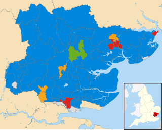
Elections to Essex County Council took place on 4 May 2017 as part of the 2017 local elections. All 75 councillors were elected from 70 electoral divisions, which each returned either one or two councillors by first-past-the-post voting for a four-year term of office.

References

  1. "Contact your local councillors". Tendring District Council. Retrieved 3 June 2024.
  2. "Mid-Year Population Estimates, UK, June 2022". Office for National Statistics . 26 March 2024. Retrieved 3 May 2024.
  3. "Mid-Year Population Estimates, UK, June 2022". Office for National Statistics . 26 March 2024. Retrieved 3 May 2024.
  4. 1 2 UK Census (2021). "2021 Census Area Profile – Tendring Local Authority (E07000076)". Nomis. Office for National Statistics . Retrieved 3 June 2024.
  5. "Chairman of the Council". Tendring District Council. Retrieved 11 May 2024.
  6. "Council minutes, 5 January 2022". Tendring District Council. Retrieved 8 June 2023.
  7. "The English Non-metropolitan Districts (Definition) Order 1972", legislation.gov.uk , The National Archives, SI 1972/2039, retrieved 31 May 2023
  8. "The English Non-metropolitan Districts (Names) Order 1973", legislation.gov.uk , The National Archives, SI 1973/551, retrieved 31 May 2023
  9. Tendring Hundred, Survey of English Place-Names, English Place-Name Society, University of Nottingham
  10. Higginbotham, Peter. "The Workhouse in Tendring, Essex" . Retrieved 8 June 2023.
  11. "Local Government Act 1972", legislation.gov.uk , The National Archives, 1972 c. 70, retrieved 31 May 2023
  12. Dedman, Simon (24 May 2023). "Colchester: Power-sharing ends between Labour and Lib Dems". BBC News. Retrieved 7 June 2023.
  13. "Compositions calculator". The Elections Centre. Retrieved 1 June 2023.
  14. "Tendring". BBC News Online . Retrieved 28 September 2009.
  15. "Council minutes". Tendring District Council. Retrieved 11 June 2022.
  16. Lodge, Will (30 December 2016). "Tendring District Council leader Neil Stock awarded an OBE in New Year's Honours list". East Anglian Daily Times. Retrieved 11 June 2022.
  17. Dwan, James (28 November 2012). "Tendring Council elects new leader". Clacton Gazette. Retrieved 11 June 2022.
  18. "The Tendring (Electoral Changes) Order 2017", legislation.gov.uk , The National Archives, SI 2017/1122, retrieved 8 June 2023
  19. "Local elections 2023: live council results for England". The Guardian.
  20. "Tendring". Local Councils. Thorncliffe. Retrieved 11 May 2024.
  21. "Council services and office locations". Tendring District Council. Retrieved 11 June 2022.
  22. "The English Indices of Deprivation 2019" (PDF). Ministry of Housing, Communities and Local Government. Retrieved 11 June 2022.
  23. "Sudbury (Suffolk, England) Full Freeview transmitter". May 2004.
  24. "Election Maps". Ordnance Survey. Retrieved 8 June 2023.
  25. "Parish Council contact details". Tendring District Council. Retrieved 8 June 2023.
  26. "East of England Region". Civic Heraldry of England. Retrieved 9 March 2021.