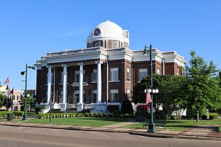
Dyer County is a county located in the westernmost part of the U.S. state of Tennessee. As of the 2020 census, the population was 36,801. The county seat is Dyersburg. Dyer County comprises the Dyersburg, TN Micropolitan Statistical Area.

Interstate 155 (I-155) is an east–west auxiliary route of Interstate 55 (I-55) that runs through the Bootheel of Missouri and the northwestern corner of Tennessee. It begins south of Hayti, Missouri at I-55, passes eastward through Caruthersville, and crosses the Mississippi River on the Caruthersville Bridge into Tennessee. The route then proceeds to Dyersburg, Tennessee, where it terminates at U.S. Route 51 (US 51). I-155 is the only road that directly connects Missouri and Tennessee, and is concurrent with US 412 for its entire length.

U.S. Route 51 (US 51), mostly overlapped by the unsigned State Route 3 (SR 3), is a north–south state highway in the U.S. state of Tennessee, that is 135.9 miles (218.71 km) long, completely within West Tennessee. It begins in Shelby County and ends in Obion County. The SR 3 designation is seen largely on mileposts.

U.S. Route 45E (US 45E) is a 61.23-mile-long (98.54 km) state highway in West Tennessee, connecting Jackson with South Fulton via Milan and Martin. For the majority of its length, it runs concurrently with unsigned State Route 43 (SR 43) for most of that highway’s length except for short segments at Martin and South Fulton, where it is cosigned with SR 216 and SR 215, respectively.

U.S. Route 45W is a 62.33-mile-long (100.31 km) United States Numbered Highway in West Tennessee, connecting Jackson with South Fulton via Humboldt, Trenton, Rutherford, and Union City. For the majority of its length, it runs concurrently with unsigned State Route 5.

State Route 22 is a 172.8-mile long (278.1 km) south-to-north state highway in the western part of Tennessee, United States. It begins at the Mississippi state line in McNairy County, where the roadway continues as Mississippi Highway 2. It ends at the Kentucky state line in Lake County, when it crosses into the Kentucky Bend, a detached portion of Fulton County, Kentucky. The monument for the 1862 Battle of Island Number Ten in the American Civil War is located on SR 22, about 3 mi (4.8 km) north of Tiptonville.

State Route 43 is a south to north highway in Tennessee that is 56.79 miles (91.39 km) long. It begins in Madison County and ends in Obion County. State Route 43 is little-known by the general public by this designation as it is overlain by U.S. Route 45E for most of its length; the "43" designation is seen largely on mileposts. Two short sections of this route at Martin and South Fulton is fully signed. SR 43 from its southern terminus to Milan is designated as a Strategic Highway Network connector route servicing the Milan Arsenal.

State Route 211 (SR 211) is a 17.23-mile (27.73 km) secondary state route in Dyer County, Tennessee, United States, that previously extended north into Obion County. SR 211 is a two-lane highway throughout its length except for a short section in northern Dyersburg.

State Route 79 is a 10.37-mile-long (16.69 km) state highway in southwestern Lake County, Tennessee. SR 79 has a dual primary and secondary designation and is one of a few state routes in Tennessee to have an aggregate (gravel) road surface.

State Route 78 is a 36.93-mile (59.43 km) long primary state highway in northwestern Tennessee, USA. This highway carries a dual primary and secondary designation, however, the majority of this highway is signed as a Primary State Highway. The only portion of SR 78 designated as secondary is between its southern terminus at SR 104 to US 51 in Dyersburg.

State Route 157 is a short secondary highway in northern Obion County, Tennessee.

State Route 5 is a 120-mile-long (190 km) north–south state highway in the western part of the U.S. state of Tennessee. Except for the section northwest of Union City, it is entirely concurrent with U.S. Route 45 and US 45W.

In Tennessee, U.S. Route 412 stretches for 181.93 miles (292.79 km) through the farmland of West Tennessee and the hills of Middle Tennessee, starting at the Missouri state line near Dyersburg and running to an interchange between I-65 and SR 99 in Columbia.

State Route 21 is a two lane highway that runs from the Mississippi River west of Tiptonville, Tennessee to the Kentucky state line north of Union City. This road provides access to Reelfoot Lake State Park.
The Mississippi River Trail is a designated bicycle and pedestrian trail that traverses the shores of the Mississippi River in the United States. The trail extends from the headwaters at Lake Itasca in Minnesota to near the mouth of the river in Venice, Louisiana. Much of the trail’s 3,000 miles (4,800 km) follows roadways used by motor vehicles, although some of the route is on multi-use trails. The segment in Minnesota has been designated as U.S. Bicycle Route 45, part of the U.S. Bicycle Route System.

State Route 105 is a 44.34-mile-long (71.36 km) east–west state highway in West Tennessee. It traverses mainly rural areas and farmland.

State Route 445 is a 12.6 mile long east-west state highway in West Tennessee. It connects the towns of Rutherford and Greenfield and provides access to Big Cypress Tree State Park.

State Route 104 is a 114.43-mile-long east–west state highway in West Tennessee.

State Route 190 is a 55.3-mile-long (89.0 km) north–south state highway that traverses the farmland of West Tennessee. It connects Trezevant and South Fulton via Pillowville, Gleason, Palmersville, and Latham.

State Route 216 is a 17.7-mile-long (28.5 km) east–west state highway in West Tennessee, connecting Rives with Martin.


