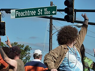
Peachtree Street is one of several major streets running through the city of Atlanta. Beginning at Five Points in downtown Atlanta, it runs North through Midtown; a few blocks after entering into Buckhead, the name changes to Peachtree Road at Deering Road. Much of the city's historic and noteworthy architecture is located along the street, and it is often used for annual parades,, as well as one-time parades celebrating events such as the 100th anniversary of Coca-Cola in 1986 and the Atlanta Braves' 1995 World Series victory.
Midtown Atlanta, or Midtown, is a high-density commercial and residential neighborhood of Atlanta, Georgia. The exact geographical extent of the area is ill-defined due to differing definitions used by the city, residents, and local business groups. However, the commercial core of the area is anchored by a series of high-rise office buildings, condominiums, hotels, and high-end retail along Peachtree Street between North Avenue and 17th Street. Midtown, situated between Downtown to the south and Buckhead to the north, is the second-largest business district in Metro Atlanta. In 2011, Midtown had a resident population of 41,681 and a business population of 81,418.

Buckhead is the uptown commercial and residential district of the city of Atlanta, Georgia, comprising approximately the northernmost fifth of the city. Buckhead is the third largest business district within the Atlanta city limits, behind Downtown and Midtown, a major commercial and financial center of the Southeast.

Buckhead Village is a neighborhood of Atlanta, Georgia, one of 42 neighborhoods in the larger Buckhead district and the community's historic business section. The Village as defined by the city as the area between Piedmont Road, Peachtree Road, and Pharr Road.

1180 Peachtree, commonly known as the Symphony Tower, is a 41-story skyscraper located at 1180 Peachtree Street in the Midtown district of Atlanta, Georgia, United States. Rising to a height of approximately 657 feet (200 m), the building includes office and retail space in its 624,996 sq ft (58,064 m2) of floor area as well as a 1,200 space parking deck. Construction was completed in 2006.
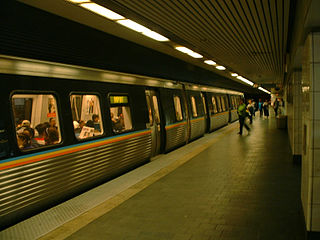
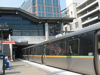
Civic Center is an elevated metro station in Atlanta, Georgia, serving the Red and Gold lines of the Metropolitan Atlanta Rapid Transit Authority (MARTA) rail system. It is located in Atlanta's SoNo district. This station has seen an increase of faregate totals and ridership in the past years due to the Megabus, which drops off and picks up passengers above the station. Additionally, there has been an increased interest in high-rise buildings in the area.

Clear Creek is a stream in northeast Atlanta that is a tributary to Peachtree Creek and part of the Chattahoochee River watershed. It has two main branches, one originating east of the high ground along which Boulevard runs and another to the west originating on the northeast side of downtown Atlanta. The easterly branch of Clear Creek begins in several springs and branches in what are now Inman Park and the Old Fourth Ward. Flowing north, the creek was joined by other branches and springs, including Angier Springs near the end of Belgrade Avenue and the so-called Ponce de Leon Springs, which were “discovered” during railroad construction in the 1860s and gave rise to the eponymous park and avenue.

SoNo is a sub-district of downtown Atlanta, Georgia, just south of Midtown. The area was defined and named by T. Brian Glass while working on a rezoning committee with Central Atlanta Progress in 2005 in order to better establish an identity for the area and give it a hipper image. SoNo refers to the area of Downtown bounded by North Avenue on the north, Central Park Place on the east and the Downtown Connector (Interstate-75/85) on the west and south.

Ponce de Leon Avenue, often simply called Ponce, provides a link between Atlanta, Decatur, Clarkston, and Stone Mountain, Georgia. It was named for Ponce de Leon Springs, in turn from explorer Juan Ponce de León, but is not pronounced as in Spanish. Several grand and historic buildings are located on the avenue.

South Downtown is a historic neighborhood of Downtown Atlanta, Georgia, United States. South Downtown is primarily home to city, county, state, and federal governmental offices, which prompted the city to adopt signage declaring the area "Government Walk." Although much of South Downtown is dominated by surface parking lots, the neighborhood was passed over during the redevelopment boom of the 1960s and 1970s that resulted in the demolition of much of Downtown's architecturally significant buildings. The result are a myriad buildings from the 1950s and earlier that retain their historic structural integrity.

The Museum of Design Atlanta (MODA) is a design museum located at 1315 Peachtree Street in Atlanta, Georgia, United States. MODA is the only museum in the Southeast devoted exclusively to the study and celebration of all things design.
Colony Square is a mixed-use development and sub-district in Midtown Atlanta, Georgia, located on Peachtree Street in between 14th and 15th Streets. The oldest high-rise development in Midtown, the sub-district was built between 1969 and 1975, with Henri Jova of Jova/Daniels/Busby serving as principal architect. It was the first mixed-use development in the Southeast.
Lindbergh, officially Lindbergh/Morosgo, is a neighborhood in the Buckhead district of Atlanta, Georgia. Most of the neighborhood consists of multi-use development combining retail, office and residential space.

Rhodes Center was Atlanta's first shopping center. It was built in 1937 by architects Ivey and Crook and was one of the largest real estate developments in Atlanta during the Depression. It was located in Midtown between Peachtree Street and Spring Street. It consisted of one-story buildings that ran along the north, west and south sides of Rhodes Hall.
North Buckhead is a neighborhood in the Buckhead district, at the northern edge of the city of Atlanta, Georgia, and is one of Atlanta's most affluent neighborhoods.
Peachtree Hills is a neighborhood within the Buckhead district of Atlanta, Georgia. It primarily contains residential buildings, however, commercial buildings are scattered throughout the neighborhood. Peachtree Battle Shopping Center is located within the borders of Peachtree Hills.

Washington–Rawson was a neighborhood of Atlanta, Georgia. It included what is now Georgia State Stadium and the large parking lot to its north, until 1997 the site of Atlanta–Fulton County Stadium, as well as the I-20-Downtown Connector interchange. Washington and Rawson streets intersected where the interchange is today. To the northwest was Downtown Atlanta, to the west Mechanicsville, to the east Summerhill, and to the south Washington Heights, now called Peoplestown.

12th and Midtown is a four-block commercial real estate development project in Midtown Atlanta along Peachtree Street and Crescent Avenue between 11th and 13th Streets. The development currently contains three of the tallest buildings in Midtown, with more buildings planned in the coming years.
The Rio Shopping Center was a 120,000-square-foot (11,000 m2) open-air shopping center in Atlanta. It was located at the southeast corner of Piedmont Avenue and North Avenue in the northwesternmost part of what is now the Old Fourth Ward, at its border of SoNo and Midtown Atlanta. It was designed by Arquitectonica in postmodern style, landscaped by Martha Schwartz and opened in the Fall of 1988. It was the first free-standing complex of its kind to be built in central Atlanta in more than twenty years.
