
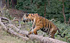
The Bengal tiger is a population of the Panthera tigris tigris subspecies and the nominate tiger subspecies. It ranks among the biggest wild cats alive today. It is considered to belong to the world's charismatic megafauna.

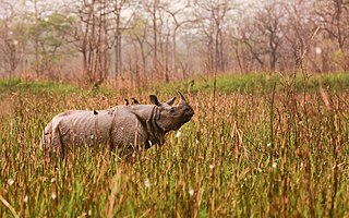
The Indian rhinoceros, also known as the greater one-horned rhinoceros, great Indian rhinoceros, or Indian rhino for short, is a rhinoceros species native to the Indian subcontinent. It is the second largest extant species of rhinoceros, with adult males weighing 2.07–2.2 tonnes and adult females 1.6 tonnes. The skin is thick and is grey-brown in colour with pinkish skin folds. They have a single horn on their snout that grows to a maximum of 57.2 cm (22.5 in). Their upper legs and shoulders are covered in wart-like bumps. They are nearly hairless, aside from the eyelashes, ear fringes and tail brush.

The Terai or Tarai is to a lowland region in parts of northern India and southern Nepal that lies to the south of the outer foothills of the Himalayas, the Sivalik Hills and north of the Indo-Gangetic Plain. This lowland belt is characterised by tall grasslands, scrub savannah, sal forests and clay rich swamps. In North India, the Terai spreads from the Yamuna River eastward across Haryana, Uttarakhand, Uttar Pradesh, Bihar and West Bengal. The Terai is part of the Terai-Duar savanna and grasslands ecoregion. Nepal's Terai stretches over 33,998.8 km2 (13,127.0 sq mi), about 23.1% of Nepal's land area, and lies at an elevation of between 67 and 300 m. The region comprises more than 50 wetlands. North of the Terai rises the Bhabar, a narrow but continuous belt of forest about 8–12 km (5.0–7.5 mi) wide.

Chitwan National Park is the first national park of Nepal. It was established in 1973 as the Royal Chitwan National Park and was granted the status of a World Heritage Site in 1984. It covers an area of 952.63 km2 (367.81 sq mi) in the subtropical Inner Terai lowlands of south-central Nepal in Nawalpur, Chitwan, Makwanpur and Parsa Districts. It ranges in elevation from about 100 m (330 ft) in the river valleys to 815 m (2,674 ft) in the Sivalik Hills.

Gorumara National Park is a national park in northern West Bengal, India. Located in the Dooars region of the Himalayan foothills, it is a medium-sized park with grasslands and forests. Gorumara National Park was established in 1992. It is primarily known for its population of Indian rhinoceros. The park was declared as the best among the protected areas in India by the Ministry of Environment and Forests for the year 2009.
Buxa Tiger Reserve is a tiger reserve and national park in northern West Bengal, India, covering an area of 760 km2 (290 sq mi). In altitude, it ranges from 60 m (200 ft) in the Gangetic Plains to 1,750 m (5,740 ft) bordering the Himalayas in the north. At least 284 bird species inhabit the reserve. Mammals present include Asian elephant, gaur, Sambar deer, clouded leopard, Indian leopard, and Asian golden cat.

Kali Tiger Reserve is a protected area and tiger reserve. It is located in Uttara Kannada district, in Karnataka, India. The park is a habitat of Bengal tigers, black panthers and Indian elephants, amongst other distinctive fauna. The Kali River flows through the tiger reserve and is the lifeline of the ecosystem and hence the name. The tiger reserve is spread over an area of 1300 square kilometres.
Valmiki National Park is a tiger reserve in the West Champaran District of Bihar, India. It is the only national park in Bihar. Valmiki Tiger Reserve covers 898.45 km2 (346.89 sq mi), which is 17.4% of the total geographical area of the district. As of 2022, there were 54 tigers in the Reserve.
Orang National Park is a national park in India located on the northern bank of the Brahmaputra River in the Darrang and Sonitpur districts of Assam. It covers an area of 79.28 km2 (30.61 sq mi). It was established as a sanctuary in 1985 and declared a national park on 13 April 1999. It is rich in flora and fauna, including great Indian rhinoceros, pygmy hog, Asian elephant, wild water buffalo and the Bengal tiger. It is the only stronghold of the rhinoceros on the north bank of the Brahmaputra.

The Terai–Duar savanna and grasslands is a narrow lowland ecoregion at the base of the Himalayas, about 25 km (16 mi) wide, and a continuation of the Indo-Gangetic Plain in India, Nepal and Bhutan. It is colloquially called Terai in the Ganges Basin east to Nepal, then Dooars in West Bengal, Bhutan and Assam east to the Brahmaputra River. It harbours the world's tallest grasslands, which are the most threatened and rare worldwide.

Bardiya National Park is a protected area in Nepal that was established in 1988 as Royal Bardia National Park. Covering an area of 968 km2 (374 sq mi) it is the largest and most undisturbed national park in Nepal's Terai, adjoining the eastern bank of the Karnali River and bisected by the Babai River in the Bardiya District. Its northern limits are demarcated by the crest of the Siwalik Hills. The Nepalgunj-Surkhet highway partly forms the southern boundary, but seriously disrupts the protected area. Natural boundaries for human settlements are formed in the west by the Geruwa, a branch of the Karnali River, and in the southeast by the Babai River.

The Upper Gangetic Plains moist deciduous forests is a tropical and subtropical moist broadleaf forests ecoregion of northern India.

Manas National Park is a national park, Project Tiger reserve, and an elephant reserve in Assam, India. Located in the Himalayan foothills, it borders the Royal Manas National Park in Bhutan. The park is known for its rare and endangered endemic wildlife such as the Assam roofed turtle, hispid hare, golden langur and pygmy hog. Manas is also famous for its population of the wild water buffalo. Because of its exceptional biodiversity, scenery, and variety of habitats, Manas National Park is a biosphere reserve and a UNESCO World Heritage Site.

The Himalayan subtropical broadleaf forests is an ecoregion that extends from the middle hills of central Nepal through Darjeeling into Bhutan and also into the Indian States of Uttar Pradesh and Bihar. It represents the east–west-directed band of subtropical broadleaf forest at an altitude of between 500 and 1,000 m along the Outer Himalayan Range, and includes several forest types traversing an east to west moisture gradient.

The Eastern Himalayan broadleaf forests is a temperate broadleaf forest ecoregion found in the middle elevations of the eastern Himalayas, including parts of Nepal, India, Bhutan, Myanmar and China. These forests have an outstanding richness of wildlife.
Kaziranga National Park is an Indian national park and a World Heritage Site in Golaghat and Nagaon districts of Assam, India. It is refuge for the world's largest population of great one-horned rhinoceros. Kaziranga has the highest density of tigers among protected areas in the world and was declared a Tiger Reserve in 2006. The park has large breeding populations of elephant, wild Asiatic water buffalo and swamp deer. Kaziranga is recognized as an Important Bird Area by Birdlife International for conservation of avifaunal species. The park has achieved notable progress in wildlife conservation with respect to other protected areas in India.Kaziranga was declared a Tiger Reserve in 2006

The Manas River, known in Bhutan as the Drangme Chhu, is a transboundary river in the Himalayan foothills between southern Bhutan, India, and China. It is the largest of Bhutan's four major river systems, with the other three being the Amo Chu or Torsa River, the Wang Chu or Raidak, and the Puna Tshang Chu or Sankosh. It is met by three other major streams before it again debouches into India in western Assam. The river flows for a total length of 400 kilometres (250 mi), including through Tibet for 24 km (15 mi), Bhutan for 272 kilometres (169 mi), and Assam for 104 kilometres (65 mi) before it joins the mighty Brahmaputra River at Jogighopa. A major tributary of the Manas, the Aie River, joins it in Assam at Bangpari.

Shuklaphanta National Park is a national park in the Terai of the Far-Western Region, Nepal, covering 305 km2 (118 sq mi) of open grasslands, forests, riverbeds and wetlands at an elevation of 174 to 1,386 m. It is bounded by the Mahakali river in the west and south. A small part extends north of the Mahendra Highway to create a wildlife corridor for seasonal migration of wildlife into the Sivalik Hills. It was gazetted in 1976 as Royal Shuklaphanta Wildlife Reserve and was enlarged to its present size in the late 1980s. A buffer zone of 243.5 km2 (94.0 sq mi) was added in 2004. It receives a mean annual rainfall of 1,579 mm (62.2 in) and harbours 700 floral, 456 bird, 56 reptile and 15 amphibian species.
Nandhaur Wildlife Sanctuary is a wildlife sanctuary in Uttarakhand, India that was created in 2012. It is located in the Terai Arc Landscape, a forest zone that stretches from Uttarakhand in India and extends into Nepal.

Bura Chapori Wildlife Sanctuary is a protected area located in the state of Assam in India. This wildlife sanctuary covers 44.06 km2, on the south bank of the Brahmaputra River in Sonitpur district. The area was declared a Reserved forest in 1974, it became a sanctuary in 1995. It is located 40 km from Tezpur town and 181 km away from Guwahati.It forms an integral part of the Laokhowa-Burachapori eco-system and is a notified buffer of the Kaziranga Tiger reserve.


