
Thackaringa is a rural locality, civil parish, railway stop and cattle station in Far Western New South Wales. [1]
Thackaringa is a rural locality, civil parish, railway stop and cattle station in Far Western New South Wales. [1]
Thackaringa is located at 141.0623°, −32.0245°, 489.263 km from Sydney and between Cockburn, South Australia on the border with South Australia and by Silverton in the north-east. Thackaringa is at an altitude of approximately 204m. [2]
Thackaringa is arid and sparsely settled with the economy derived mainly from broad acre agriculture, though some mining occurs. [3] Thackaringa is on the Silverton Tramway and Thackaringa railway station operated from 2 January 1889 until 12-Jan-1970. [4] [5]
The nearest town is Cockburn, South Australia.
The northern part of the district is cut by a large retrograde shear zone containing large garnets and refractory minerals.... There are many other small mineral deposits found in the Thackaringa district where quartz veins and/or granitic rocks have crystallised including the Thackaringa davidite belt and pods of large rutile crystals. [6]
Thackaringa has a Köppen climate classification of BWh and BWk desert.
The Parish is part of the traditional lands of the Wiljali people. [7]
The area was opened by Europeans due to the discovery of minerals in the 19th century. [8] [9] There was a grazing property, known as Thackaringa Station, and the first discovery of silver ore in the area was made there in 1875, by Julius Nickel who was digging a well. In 1888, the population of Thackaringa was between 200 and 300 people. [10] Silver, lead, feldspar and beryl are still extracted in the area today. [11]

The San Juan Mountains is a high and rugged mountain range in the Rocky Mountains in southwestern Colorado and northwestern New Mexico. The area is highly mineralized and figured in the gold and silver mining industry of early Colorado. Major towns, all old mining camps, include Creede, Lake City, Silverton, Ouray, and Telluride. Large scale mining has ended in the region, although independent prospectors still work claims throughout the range. The last large scale mines were the Sunnyside Mine near Silverton, which operated until late in the 20th century and the Idarado Mine on Red Mountain Pass that closed down in the 1970s. Famous old San Juan mines include the Camp Bird and Smuggler Union mines, both located between Telluride and Ouray.
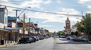
Broken Hill is an inland mining city in the far west of outback New South Wales, Australia. It is near the border with South Australia on the crossing of the Barrier Highway (A32) and the Silver City Highway (B79), in the Barrier Range. It is 315 m (1,033 ft) above sea level, with a hot desert climate, and an average rainfall of 235 mm (9 in). The closest major city is Adelaide, the capital of South Australia, which is more than 500 km (311 mi) to the southwest and linked via route A32.

Cobalt is a town in Timiskaming District, Ontario, Canada. It had a population of 1,118 at the 2016 Census.

Silverton is a small village at the far west of New South Wales, Australia, 26 kilometres (16 mi) north-west of Broken Hill. At the 2016 census, Silverton had a population of 50.

The Australian state of New South Wales has an extensive network of railways, which were integral to the growth and development of the state. The vast majority of railway lines were government built and operated, but there were also several private railways, some of which operate to this day.

Llanymynech is a village straddling the border between Montgomeryshire/Powys, Wales, and Shropshire, England, about 9 miles (14 km) north of the Welsh town of Welshpool. The name is Welsh for "Church of the Monks". The village is on the banks of the River Vyrnwy, and the Montgomery Canal passes through it.
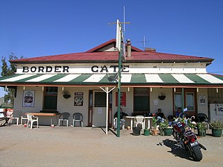
Cockburn is a town and locality in the east of the Australian state of South Australia at the border with New South Wales near Broken Hill.

Sir John Alexander Cockburn was Premier of South Australia from 27 June 1889 to 18 August 1890.

The Silverton Tramway was a 58-kilometre-long 1,067 mm railway line running from Cockburn on the South Australian state border to Broken Hill in New South Wales. Operating between 1888 and 1970, it served the mines in Broken Hill, and formed the link between the 1,435 mmstandard gauge New South Wales Government Railways and the narrow gauge South Australian Railways lines. It was owned and operated by the Silverton Tramway Company (STC).

The Sydney–Perth rail corridor is a 1435 mmstandard gauge railway route that runs for 4352 kilometres (2704 mi) across Australia from Sydney, New South Wales, to Perth, Western Australia. Most of the route is under the control of the Australian Rail Track Corporation.
The Cobalt silver rush started in 1903 when huge veins of silver were discovered by workers on the Temiskaming and Northern Ontario Railway (T&NO) near the Mile 103 post. By 1905 a full-scale silver rush was underway, and the town of Cobalt, Ontario sprang up to serve as its hub. By 1908 Cobalt produced 9% of the world's silver, and in 1911 produced 31,507,791 ounces of silver. However, the good ore ran out fairly rapidly, and most of the mines were closed by the 1930s. There were several small revivals over the years, notably in World War II and again in the 1950s, but both petered out and today there is no active mining in the area. In total, the Cobalt area mines produced 460 million ounces of silver.
Silver Centre is a ghost town in Timiskaming District, Northeastern Ontario, Canada, situated in South Lorrain Township. It is located approximately 35 km (22 mi) south of North Cobalt, and 3 km (1.9 mi) west of Highway 567. Silver Centre was a secondary camp to the great silver fields of Cobalt, discovered in 1903. There are no current residents in Silver Centre. It is still an active mineral field and does at times have active mineral exploration.
The Silverton Tramway 48s class are a class of diesel locomotives built by AE Goodwin, Auburn for the Silverton Tramway in 1960–1961. The State Rail Authority 48 class and South Australian Railways 830 class are of a very similar design.

Broken Hill railway station is a heritage-listed railway station located on the Broken Hill line in Broken Hill, New South Wales, Australia. It was added to the New South Wales State Heritage Register on 2 April 1999.
Cockburn railway station was located on the Silverton Tramway serving the town of Cockburn on the New South Wales / South Australian state border.

Colinton is a locality in the Snowy Monaro Region, New South Wales, Australia. At the 2016 census, it had a population of 127. There was once a village and railway station of the same name.
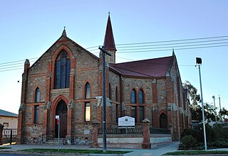
Wesley Uniting Church is a heritage-listed Uniting church at Cobalt Street, Broken Hill, City of Broken Hill, New South Wales, Australia. It was designed by Frederick William Dancker and built from 1885 to 1888 by Messrs. Walter and Morris. It is also known as Wesley Uniting Church and Hall Group, Wesleyan Uniting Church Group, Wesley Church and Wesley Hall. The property is owned by the Uniting Church in Australia. It was added to the New South Wales State Heritage Register on 23 April 2010 and on the Australian Register of the National Estate.

Naradin is a rural locality in Far western New South Wales and a civil parish of Yancowinna County.
Wallarunga is a rural locality and ghost town located at −32.031799316 and 141.317901611 about 10 Kilometers south west of Broken Hill, New South Wales.
William Jamieson was an Australian surveyor, and a member of the syndicate that founded the Broken Hill Proprietary mine at Broken Hill. He was, in 1884, the company's first mine manager and, in 1885, its first general manager.