In physical geography, tundra is a type of biome where tree growth is hindered by frigid temperatures and short growing seasons. The term tundra comes through Russian тундра from the Kildin Sámi word тӯндар meaning "uplands", "treeless mountain tract". There are three regions and associated types of tundra: Arctic tundra, alpine tundra, and Antarctic tundra.

In meteorology, a cyclone is a large air mass that rotates around a strong center of low atmospheric pressure, counterclockwise in the Northern Hemisphere and clockwise in the Southern Hemisphere as viewed from above. Cyclones are characterized by inward-spiraling winds that rotate about a zone of low pressure. The largest low-pressure systems are polar vortices and extratropical cyclones of the largest scale. Warm-core cyclones such as tropical cyclones and subtropical cyclones also lie within the synoptic scale. Mesocyclones, tornadoes, and dust devils lie within the smaller mesoscale. Upper level cyclones can exist without the presence of a surface low, and can pinch off from the base of the tropical upper tropospheric trough during the summer months in the Northern Hemisphere. Cyclones have also been seen on extraterrestrial planets, such as Mars, Jupiter, and Neptune. Cyclogenesis is the process of cyclone formation and intensification. Extratropical cyclones begin as waves in large regions of enhanced mid-latitude temperature contrasts called baroclinic zones. These zones contract and form weather fronts as the cyclonic circulation closes and intensifies. Later in their life cycle, extratropical cyclones occlude as cold air masses undercut the warmer air and become cold core systems. A cyclone's track is guided over the course of its 2 to 6 day life cycle by the steering flow of the subtropical jet stream.

Altostratus is a middle-altitude cloud genus made up of water droplets, ice crystals, or a mixture of the two. Altostratus clouds are formed when large masses of warm, moist air rise, causing water vapor to condense. Altostratus clouds are usually gray or blueish featureless sheets, although some variants have wavy or banded bases. The sun can be seen through thinner altostratus clouds, but thicker layers can be quite opaque.

In meteorology, precipitation is any product of the condensation of atmospheric water vapor that falls from clouds due to gravitational pull. The main forms of precipitation include drizzle, rain, sleet, snow, ice pellets, graupel and hail. Precipitation occurs when a portion of the atmosphere becomes saturated with water vapor, so that the water condenses and "precipitates" or falls. Thus, fog and mist are not precipitation but colloids, because the water vapor does not condense sufficiently to precipitate. Two processes, possibly acting together, can lead to air becoming saturated: cooling the air or adding water vapor to the air. Precipitation forms as smaller droplets coalesce via collision with other rain drops or ice crystals within a cloud. Short, intense periods of rain in scattered locations are called showers.
El Niño–Southern Oscillation (ENSO) is an irregular periodic variation in winds and sea surface temperatures over the tropical eastern Pacific Ocean, affecting the climate of much of the tropics and subtropics. The warming phase of the sea temperature is known as El Niño and the cooling phase as La Niña. The Southern Oscillation is the accompanying atmospheric component, coupled with the sea temperature change: El Niño is accompanied by high air surface pressure in the tropical western Pacific and La Niña with low air surface pressure there. The two periods last several months each and typically occur every few years with varying intensity per period.

The Pacific decadal oscillation (PDO) is a robust, recurring pattern of ocean-atmosphere climate variability centered over the mid-latitude Pacific basin. The PDO is detected as warm or cool surface waters in the Pacific Ocean, north of 20°N. Over the past century, the amplitude of this climate pattern has varied irregularly at interannual-to-interdecadal time scales. There is evidence of reversals in the prevailing polarity of the oscillation occurring around 1925, 1947, and 1977; the last two reversals corresponded with dramatic shifts in salmon production regimes in the North Pacific Ocean. This climate pattern also affects coastal sea and continental surface air temperatures from Alaska to California.
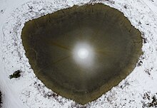
A singularity is a weather phenomenon likely to occur with reasonable regularity around a specific approximate calendar date, outside of more general seasonal weather patterns. The existence of singularities is disputed, some considering them due to seeing patterns in noise and statistical artifacts from small samples.
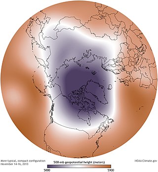
A circumpolar vortex, or simply polar vortex, is a large region of cold, rotating air; polar vortices encircle both of Earth's polar regions. Polar vortices also exist on other rotating, low-obliquity planetary bodies. The term polar vortex can be used to describe two distinct phenomena; the stratospheric polar vortex, and the tropospheric polar vortex. The stratospheric and tropospheric polar vortices both rotate in the direction of the Earth's spin, but they are distinct phenomena that have different sizes, structures, seasonal cycles, and impacts on weather.

The Madden–Julian oscillation (MJO) is the largest element of the intraseasonal variability in the tropical atmosphere. It was discovered in 1971 by Roland Madden and Paul Julian of the American National Center for Atmospheric Research (NCAR). It is a large-scale coupling between atmospheric circulation and tropical deep atmospheric convection. Unlike a standing pattern like the El Niño–Southern Oscillation (ENSO), the Madden–Julian oscillation is a traveling pattern that propagates eastward, at approximately 4 to 8 m/s, through the atmosphere above the warm parts of the Indian and Pacific oceans. This overall circulation pattern manifests itself most clearly as anomalous rainfall.
The climate in urban areas differs from that in neighboring rural areas, as a result of urban development. Urbanization greatly changes the form of the landscape, and also produces changes in an area's air. The study of urban climate is urban climatology.
The iris hypothesis was a hypothesis proposed by Richard Lindzen and colleagues in 2001 that suggested increased sea surface temperature in the tropics would result in reduced cirrus clouds and thus more infrared radiation leakage from Earth's atmosphere. His study of observed changes in cloud coverage and modeled effects on infrared radiation released to space as a result seemed to support the hypothesis. This suggested infrared radiation leakage was hypothesized to be a negative feedback in which an initial warming would result in an overall cooling of the surface.
Edward George "Taffy" Bowen, CBE, FRS was a Welsh physicist who made a major contribution to the development of radar. He was also an early radio astronomer, playing a key role in the establishment of radioastronomy in Australia and the United States.

Extratropical cyclones, sometimes called mid-latitude cyclones or wave cyclones, are low-pressure areas which, along with the anticyclones of high-pressure areas, drive the weather over much of the Earth. Extratropical cyclones are capable of producing anything from cloudiness and mild showers to severe gales, thunderstorms, blizzards, and tornadoes. These types of cyclones are defined as large scale (synoptic) low pressure weather systems that occur in the middle latitudes of the Earth. In contrast with tropical cyclones, extratropical cyclones produce rapid changes in temperature and dew point along broad lines, called weather fronts, about the center of the cyclone.
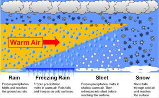
In meteorology, the different types of precipitation often include the character, formation, or phase of the precipitation which is falling to ground level. There are three distinct ways that precipitation can occur. Convective precipitation is generally more intense, and of shorter duration, than stratiform precipitation. Orographic precipitation occurs when moist air is forced upwards over rising terrain and condenses on the slope, such as a mountain.

Major environmental issues caused by contemporary climate change in the Arctic region range from the well-known, such as the loss of sea ice or melting of the Greenland ice sheet, to more obscure, but deeply significant issues, such as permafrost thaw, as well as related social consequences for locals and the geopolitical ramifications of these changes. The Arctic is likely to be especially affected by climate change because of the high projected rate of regional warming and associated impacts. Temperature projections for the Arctic region were assessed in 2007: These suggested already averaged warming of about 2 °C to 9 °C by the year 2100. The range reflects different projections made by different climate models, run with different forcing scenarios. Radiative forcing is a measure of the effect of natural and human activities on the climate. Different forcing scenarios reflect things such as different projections of future human greenhouse gas emissions.

Polar amplification is the phenomenon that any change in the net radiation balance tends to produce a larger change in temperature near the poles than in the planetary average. This is commonly referred to as the ratio of polar warming to tropical warming. On a planet with an atmosphere that can restrict emission of longwave radiation to space, surface temperatures will be warmer than a simple planetary equilibrium temperature calculation would predict. Where the atmosphere or an extensive ocean is able to transport heat polewards, the poles will be warmer and equatorial regions cooler than their local net radiation balances would predict. The poles will experience the most cooling when the global-mean temperature is lower relative to a reference climate; alternatively, the poles will experience the greatest warming when the global-mean temperature is higher.
Teleconnection in atmospheric science refers to climate anomalies being related to each other at large distances. The most emblematic teleconnection is that linking sea-level pressure at Tahiti and Darwin, Australia, which defines the Southern Oscillation. Another well-known teleconnection links the sea-level pressure over Iceland with the one over the Azores, traditionally defining the North Atlantic Oscillation (NAO).

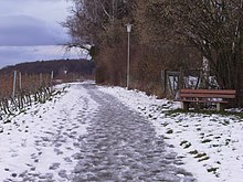
Rain is water droplets that have condensed from atmospheric water vapor and then fall under gravity. Rain is a major component of the water cycle and is responsible for depositing most of the fresh water on the Earth. It provides water for hydroelectric power plants, crop irrigation, and suitable conditions for many types of ecosystems.

The history of the scientific discovery of climate change began in the early 19th century when ice ages and other natural changes in paleoclimate were first suspected and the natural greenhouse effect was first identified. In the late 19th century, scientists first argued that human emissions of greenhouse gases could change Earth's energy balance and climate. Many other theories of climate change were advanced, involving forces from volcanism to solar variation. In the 1960s, the evidence for the warming effect of carbon dioxide gas became increasingly convincing. Some scientists also pointed out that human activities that generated atmospheric aerosols could have cooling effects as well.

A cold-core low, also known as an upper level low or cold-core cyclone, is a cyclone aloft which has an associated cold pool of air residing at high altitude within the Earth's troposphere, without a frontal structure. It is a low pressure system that strengthens with height in accordance with the thermal wind relationship. If a weak surface circulation forms in response to such a feature at subtropical latitudes of the eastern north Pacific or north Indian oceans, it is called a subtropical cyclone. Cloud cover and rainfall mainly occurs with these systems during the day.