The Angel, Islington

Last updated

The Angel, Islington
The Angel, Islington (geograph 5052750).jpg
The 1903 Angel Hotel (now offices) on the original corner site with the current pub to the right
Islington London UK location map.svg
Red pog.svg
Location in the London Borough of Islington
Former names
  • Angel Inn
  • Angel Hotel
General information
Location Angel, London Borough of Islington, Greater London
Address1 Islington High Street
CountryEngland
Coordinates 51°31′55″N0°06′22″W / 51.532°N 0.106°W / 51.532; -0.106
Current tenants
Completed1903 (current premises)
Renovated1979–1982
OwnerHamilton Investment Properties
Technical details
Floor count6
Floor area1,083 square metres (11,660 sq ft)
Design and construction
Architect(s) Eedle and Meyers [1]
Renovating team
Architect(s) Elsom Pack & Roberts
Renovating firm McLaughlin & Harvey Ltd
Listed Building – Grade II
Official nameThe Angel
Designated31 January 1991
Reference no.1207594 [1]

The Angel, Islington, is a historic landmark and a series of buildings that have stood on the corner of Islington High Street and Pentonville Road in Islington, London, England. The land originally belonged to the Clerkenwell Priory and has had various properties built on it since the 16th century. An inn on the site was called the "Angel Inn" by 1614, and the crossing became generally known as "the Angel". The site was bisected by the New Road, which opened in 1756, and properties on the site have been rebuilt several times up to the 20th century. The corner site gave its name to Angel tube station, opened in 1901, and the surrounding Angel area of London.

Contents

The current structure was completed in 1903 and was known as the Angel Hotel. The building was acquired by J. Lyons and Co. in 1921 and was used as a restaurant. In 1935 it was chosen as a property for the British version of Monopoly . The building was sold to the London County Council in 1959 to be demolished as part of plans for road improvement works that did not take place. It was returned to private ownership, renovated from 1979 and reopened in 1982 as the Angel Corner House. It contained a branch of the Co-operative Bank until 2024. It is currently used as offices, and is a grade II listed building. In 1998 a new pub called the Angel, operated by pub chain J D Wetherspoon, opened at an adjacent premises. This was later sold and renamed The Junction, to be run independently.

History

Early history

In the early 16th century, a building in this area of London on the Great North Road was known as the Sheepcote. It was named after lands belonging to St John's Priory. [2] The building was being used as an inn by the end of the 16th century and was known as the Angel by 1614. [3] The inn took its name from the Angel of the Annunciation which appeared on the sign. [4]

The Angel Inn became a useful stop when travelling from the City of London, as the rural area outside it was considered dangerous, with travellers having armed escorts from Wood's Close [5] [6] to Islington. [7] Despite its name, and common association with Islington, the grounds of the inn and all of the western edge of Islington High Street were in neighbouring Clerkenwell. [3]

17th–18th century

William Hogarth's portrait The Stage Coach is believed to be based in the grounds of the Angel, Islington. The stagecoach, or a rural farm Tavern.jpg
William Hogarth's portrait The Stage Coach is believed to be based in the grounds of the Angel, Islington.

By 1630, the inn was owned by William Riplingham, officer of the Great Wardrobe. Riplingham built an extension of the courtyard ranges on the site of the Angel Inn around 1638, for which he was fined due to breaking building regulations. These ranges survived up to the early 19th century. By 1677, the Angel was owned by James Compton, 3rd Earl of Northampton, and occupied by Edward Fawcett, who ran the inn until his death in 1696. The premises accommodated livestock traders (drovers) destined for Smithfield Market, as well as long-distance travellers. [3]

In the early 18th century, the Angel was the largest coaching house in a row of several along Islington High Street. Robert Bartholomew took over ownership of the inn in 1744 and was succeeded by his son, Christopher, around 1766, who continued to run it until the end of the century. The inn was the subject of William Hogarth's 1747 drawing, The Stage-Coach, Or The Country Inn Yard, which depicted busy coaching inn trade and traffic. [3] In his book The Inns and Taverns of Old London published in 1909, Henry C. Shelley said "The Angel dates back to before 1665... In the seventeenth century and later, as old pictures testify, the inn presented the usual features of a large old country hostelry." [8]

The building of the New Road in 1756 bisected the Angel Inn site and the stable buildings were cut off on the southern side. The inn was on the northern side, on the corner of what is now the junction of Islington High Street and Pentonville Road, while the stables were now on what is St John Street, adjacent to the New Inn, which had been established in 1744. The Angel benefited from the extra traffic brought by the New Road, and in addition to accommodation provided a number of assembly rooms for public meetings. The author and political activist Thomas Paine is believed to have begun writing Rights of Man at the Angel in 1790, and there is a monument on Islington High Street commemorating this. [3]

19th century

By the start of the 19th century, fields south of the Angel were being built on, resulting in all land towards the City of London becoming urban. The Angel was rebuilt during 1819 and 1820 to become a post house and meeting place for various London businesses. The redevelopment was directed by Charles Smith, and subsequently let to James Smith. The size of the inn was reduced and adjacent plots were sold off, allowing development of houses and shops, though the inn's grounds remained substantial. It was now advertised as the "Angel Inn Tavern and Hotel for Gentlemen and Families", and the front of the tavern faced the New Road. [3]

View of the Angel, Islington from the southeast, in the late 1890s The Angel Islington 1890s.jpg
View of the Angel, Islington from the southeast, in the late 1890s

By the 1850s, the Angel was reported to be in decline. The New Road was renamed Pentonville Road in 1857, and the inn's management successfully put shop fronts on the road around 1870, along with extensive refurbishments. In 1880, the Angel was refurbished internally for William Henry and Richard Baker, later to become large-scale pub owners. In 1883 the stables were sold to the London Street Tramways and the main building was sold to the brewers Truman, Hanbury, Buxton & Co. in 1896. [3]

Construction of a new building in pale terracotta stone with a corner cupola was started in 1899 by the architects Frederick James Eedle and Sydney Herbert Meyers. [9] The brewers proclaimed the new building to be "the widest-known hostelry in the world", and work was completed in 1903. [3] A panel on a second floor balcony still bears this opening date. The parish of Clerkenwell became the Metropolitan Borough of Finsbury in 1900 and when the City and South London Railway opened a new tube station in the area in 1901 it was named Angel. [10]

20th–21st century

Detail on the south face of the building The Angel, Islington (South Face - 03).jpg
Detail on the south face of the building

The pub ceased trading in 1921 and the building was sold to restaurateurs J. Lyons and Co. [9] It was adapted as the flagship site of the business, though it was not technically a standard Lyons Corners House. [3] The restaurant remained popular, and could accommodate up to 300 people, as did Lyons Corner Houses across London throughout the 1920s and 30s, but fell out of favour as fast food began to become popular in the 1950s. [3] [11]

In 1959 The Angel was closed and sold to the London County Council as part of a plan to demolish it to make way for a new road scheme at the Angel intersection. It was used temporarily by the City University. [9] Finsbury merged with the Metropolitan Borough of Islington to form the London Borough of Islington in 1965 and ownership of the site passed to the Greater London Council. The proposals for demolition of the site along with road changes were opposed by Homes before Roads and the Islington Society. Plans to alter the intersection and create a layout similar to that at Old Street roundabout were abandoned and the building was saved from demolition. [3]

The Greater London Council sold the building to the New River Company, with the property becoming part of the London Merchant Securities portfolio. The building was renovated between 1979 and 1982 by McLaughlin & Harvey Ltd with architects Elsom Pack & Roberts converting the building for office use and renaming it Angel Corner House. The ground floor is now a branch of The Co-operative Bank, and the ORC International market research agency occupies the upper floors. [3] The building is now privately owned by Hamilton Investment Properties. [12]

The building, along with this section of Islington High Street, has been part of the Angel conservation area since 1981 [13] and The Corner House has been a listed building since 1991 and is Grade II on the National Heritage List for England. [1] The council describe this as "the character or appearance of which it is desirable to preserve or enhance". [14] Local planning regulations stipulate that new development in the area must not be taller than the dome on the Angel Corner House. [15]

The modern Angel pub, as previously run by J D Wetherspoon Angel, Islington, N1 (2506088634).jpg
The modern Angel pub, as previously run by J D Wetherspoon

On 27 October 1998, a J D Wetherspoon pub named The Angel opened at 3 Islington High Street, adjacent to the former pub building. [16] It stands on the part of the original Angel Inn site that was redeveloped as shops in 1820. [3] In 2022, the pub was scheduled to be put on the market as part of a general programme for Wetherspoon pubs across the country. [17] [18] The pub was later sold and renamed The Junction. [19]

Ten Four Pentonville Road is a redevelopment of Angel Mews. It is located at the site of the original Angel Inn's stables. [20] The Hilton London Angel Islington Hotel is named after the pub. It is located on Upper Street to the north of the original Angel. [21]

Cultural references

"The Angel Islington" is a property in the British version of Monopoly . In the game it is the third-cheapest property on the board, reflecting the downmarket state of Islington through most of the 20th century until its gentrification in the 1980s. [22] Victor Watson, of British manufacturers John Waddington Ltd, and his secretary, Marjory Philips, decided to include the property on the board whilst taking tea at the cafe. [3] [23] This account of events appears on a plaque displayed in the bank within the building; the inscription says it is the "only site on the board named after a building". [24] It is part of the light blue group with Pentonville Road and Euston Road. [4] In the game, a house at the Angel costs £50; by the turn of the 21st century a house on Islington High Street fetched around £600,000. [22]

In 1827, James Pollard painted The Royal Mail Coaches for the North Leaving the Angel, Islington, currently on display in the Tate Gallery. [25] The Charles Dickens novel Oliver Twist contains a reference to the Angel, where "London began in earnest". [3] Neil Gaiman's fantasy television series Neverwhere has a character named Angel Islington, after the inn. [26] "The Angel, Islington" is the opening track on singer/songwriter Frank Turner's album Positive Songs for Negative People . [27]

Related Research Articles

<span class="mw-page-title-main">Pub</span> Establishment that serves alcoholic drinks

A pub is a drinking establishment licensed to serve alcoholic drinks for consumption on the premises. The term first appeared in the late 17th century, to differentiate private houses from those open to the public as alehouses, taverns and inns. Today, there is no strict definition, but CAMRA states a pub has four characteristics:

  1. is open to the public without membership or residency
  2. serves draught beer or cider without requiring food be consumed
  3. has at least one indoor area not laid out for meals
  4. allows drinks to be bought at a bar
<span class="mw-page-title-main">London Borough of Islington</span> London borough in United Kingdom

The London Borough of Islington is a London borough which forms part of Inner London, England. Islington has an estimated population of 215,667. It was formed in 1965, under the London Government Act 1963, by the amalgamation of the metropolitan boroughs of Islington and Finsbury.

<span class="mw-page-title-main">Clerkenwell</span> Area of central London

Clerkenwell is an area of central London, England.

<span class="mw-page-title-main">King's Cross, London</span> Area of central London in England

King's Cross is a district in the London Boroughs of Camden and Islington, it’s on either side of Euston Road, in the outskirts of north London and central London, England, 1.5 miles (2.4 km) north of Charing Cross. It is bordered by Barnsbury to the north, Clerkenwell to the southeast, Angel to the east, Holborn and Bloomsbury to the south, Euston to the west and Camden Town to the northwest. It is served by two major rail termini, St Pancras and King's Cross. King's Cross station is the terminus of one of the major rail routes between London and the North.

<span class="mw-page-title-main">Islington</span> District of London, England

Islington is a district in the north of Greater London, England, and part of the London Borough of Islington. It is a mainly residential district of Inner London, extending from Islington's High Street to Highbury Fields, encompassing the area around the busy High Street, Upper Street, Essex Road, and Southgate Road to the east.

<span class="mw-page-title-main">Euston Road</span> Thoroughfare in central London, England

Euston Road is a road in Central London that runs from Marylebone Road to King's Cross. The route is part of the London Inner Ring Road and forms part of the London congestion charge zone boundary. It is named after Euston Hall, the family seat of the Dukes of Grafton, who had become major property owners in the area during the mid-19th century.

<span class="mw-page-title-main">Pentonville Road</span> Road in central London

Pentonville Road is a road in Central London that runs west to east from Kings Cross to City Road at The Angel, Islington. The road is part of the London Inner Ring Road and part of the boundary of the London congestion charge zone.

J D Wetherspoon plc is a pub company operating in the United Kingdom and Ireland. The company was founded in 1979 by Tim Martin and is based in Watford. It operates the sub-brand of Lloyds No.1 bars, and 56 Wetherspoon hotels. Wetherspoon is known for converting unconventional premises, such as former cinemas and banks, into pubs. The company is publicly listed on the London Stock Exchange and is a constituent of the FTSE 250 Index.

Farringdon is an area in London and is located in the London Borough of Islington. It lies just north of the border with the City of London in Central London and close to Holborn. The term is used to describe the area around Farringdon station.

<span class="mw-page-title-main">Metropolitan Borough of Finsbury</span>

The Metropolitan Borough of Finsbury was a metropolitan borough within the County of London from 1900 to 1965, when it was amalgamated with the Metropolitan Borough of Islington to form the London Borough of Islington.

<span class="mw-page-title-main">Pentonville</span> Human settlement in England

Pentonville is an area in North London, located in the London Borough of Islington. It is located 1.75 miles (2.82 km) north-northeast of Charing Cross on the Inner Ring Road. Pentonville developed in the northwestern edge of the ancient parish of Clerkenwell on the New Road. It is named after Henry Penton, the developer of the area.

<span class="mw-page-title-main">Liverpool Road</span>

Liverpool Road is a street in Islington, North London. It covers a distance of 1+14 miles (2.0 km) between Islington High Street and Holloway Road, running roughly parallel to Upper Street through the area of Barnsbury. It contains several attractive terraces of Georgian houses and Victorian villas, many of which are listed buildings. There are a number of pubs, small businesses and restaurants along its route, as well as some secluded garden squares. The vast majority of the street is residential, with a bustling shopping and business area at the southern, Angel, end.

<span class="mw-page-title-main">Upper Street</span>

Upper Street is the main street of the Islington district of inner north London, and carries the A1 road. It begins at the junction of the A1 and Liverpool Road, continuing on from Islington High Street which runs from the crossroads at Pentonville Road and City Road and runs roughly northwards from outside the main entrance to Angel Underground station, then past the Business Design Centre, then splits at Islington Green, then past The Screen On The Green cinema, past Islington Town Hall, ending at Highbury & Islington tube station on Highbury Corner, where the A1 carries on as Holloway Road, part of the Great North Road.

<span class="mw-page-title-main">St John Street, London</span>

St John Street is a historic street located in Clerkenwell, Islington, north London, England.

<span class="mw-page-title-main">A1 in London</span> The section of A1 road in Greater London

The A1 in London is the southern part of the A1 road. It starts at Aldersgate in the City of London, passing through the capital to Borehamwood on the northern fringe of Greater London, before continuing to Edinburgh. The road travels through the City and three London boroughs: Islington, Haringey and Barnet, which include the districts of Islington, Holloway, Highgate, Hendon and Mill Hill, and travels along Upper Street and Holloway Road, crossing the North Circular Road in Hendon, a district in the London Borough of Barnet.

<span class="mw-page-title-main">Caledonian Road, London</span> Road in London Borough of Islington

Caledonian Road passes for about a mile and a half north–south through the London Borough of Islington. It connects North London, from Camden Road near its junction with Holloway Road, and central London's Pentonville Road in the south. It is known colloquially as the "Cally" and forms the entirety of the A5203.

<span class="mw-page-title-main">Angel, London</span> Human settlement in England

The Angel is an area on the northern fringes of Central London within the London Borough of Islington. It is 2 miles (3.2 km) north-northeast of Charing Cross on the Inner Ring Road at a busy transport intersection. The area is identified in the London Plan as one of 35 major centres in London. It is a significant commercial and retail centre, and a business improvement district. The Angel straddles the ancient boundary of the parishes of Clerkenwell and Islington that later became the metropolitan boroughs of Finsbury and Islington. It is named from the former Angel Inn which stood on the corner of Islington High Street and Pentonville Road. Since 1965 the whole area has formed part of the London Borough of Islington in Greater London.

<span class="mw-page-title-main">Finsbury Town Hall</span> Municipal building in London, England

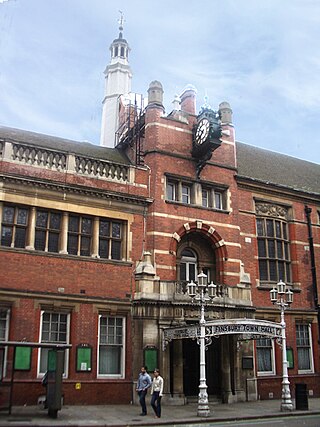
Finsbury Town Hall is a municipal building in Finsbury, London. The structure is a Grade II* listed building.

<span class="mw-page-title-main">Wilmington Square</span> Garden square in Islington, London

Wilmington Square is a garden square in Clerkenwell, Central London. It is bounded by Regency and Victorian terraces, most of which are listed buildings. The central public gardens contain flower beds and mature trees, a pavilion or shelter, and a water fountain.

References

Citations

  1. 1 2 3 Historic England, "The Angel (1207594)", National Heritage List for England , retrieved 9 October 2020
  2. Baggs, A P; Bolton, Diane K; Croot, Patricia E C (1985). Baker, T F T; Elrington, C R (eds.). "Islington: Manors". A History of the County of Middlesex. 8, Islington and Stoke Newington Parishes. London: 51–57. Retrieved 1 September 2015.
  3. 1 2 3 4 5 6 7 8 9 10 11 12 13 14 15 Temple, Philip, ed. (2008). "The Angel and Islington High Street". Survey of London. 47 : Northern Clerkenwell and Pentonville. London: 439–455. Retrieved 31 August 2015.
  4. 1 2 Moore 2003, p. 210.
  5. Dodsley, Robert; Dodsley, James (1761). "London and Its Environs Described". The Grub Street Project. Retrieved 31 May 2024. A street which extends from the end of St. John's street almost to the turnpike in Islington road.
  6. Willats, Eric A. (April 2021). Streets with a Story: The Book of Islington (PDF). Islington Local History Education Trust. ASIN   B000X86H42. The name of a rural avenue planted with trees before the beginning of the 19th century. Site of Northampton Street, Pentonville, after 1939 Agdon Street.
  7. Weinreb et al 2008, p. 23.
  8. Shelley, Henry C (1909). Inns and Taverns of Old London. BoD – Books on Demand. p. 88. ISBN   978-3-867-41508-8.
  9. 1 2 3 Baggs, A P; Bolton, Diane K; Croot, Patricia E C (1985). Baker, T F T; Elrington, C R (eds.). "Islington: Growth". A History of the County of Middlesex. 8 : Islington and Stoke Newington Parishes. London: 9–19. Retrieved 31 August 2015.
  10. Moving People in Tomorrow's World: Proceedings of a Conference Organized by the Institution of Civil Engineers and Held in London on 2 October 1986. Thomas Telford. 1987. p. 40. ISBN   978-0-727-70391-0.
  11. Moore 2003, p. 212.
  12. "Angel Corner House". Hamilton Investment Properties. Archived from the original on 18 May 2015. Retrieved 14 September 2015.
  13. CA18 Leaflet (PDF) (Report). Islington London Borough Council. p. 2. Archived from the original (PDF) on 25 September 2015. Retrieved 17 September 2015.
  14. "Angel conservation area – CA18". Islington London Borough Council. Archived from the original on 25 September 2015. Retrieved 17 September 2015.
  15. Tall Buildings Evidence Base Report (PDF) (Report). p. 44. Archived from the original (PDF) on 25 September 2015. Retrieved 17 September 2015.
  16. "The Angel, Islington". J D Wetherspoon. Retrieved 14 September 2015.
  17. "Wetherspoon's has put nine of its London pubs up for sale". Time Out. 28 September 2022. Retrieved 3 October 2022.
  18. "Full list of Wetherspoons closing as 32 pubs put up for sale". The Independent. 28 September 2022. Retrieved 3 October 2022.
  19. "Angel, Islington: London Wetherspoons becomes independent pub The Junction - menu and sports". London World. Retrieved 5 October 2023.
  20. "Urban Geology: Two New Buildings at The Angel, Islington" (PDF). University College London. Retrieved 17 September 2015.
  21. "Hilton London Angel Islington". Hilton. Retrieved 17 September 2015.
  22. 1 2 Moore 2003, p. 215.
  23. Moore 2003, pp. 210, 219.
  24. "Death of Mr Monopoly, Yorkshire businessman Victor Watson, at 86". Yorkshire Post. 26 February 2015. Retrieved 16 September 2015.
  25. "The Royal Mail Coaches for the North Leaving the Angel, Islington". Tate Gallery. Retrieved 21 September 2015.
  26. Weinstock 2014, p. 13.
  27. "Frank Turner, Positive Songs for Negative People review". The Guardian. 1 August 2015. Retrieved 16 September 2015.

Sources

  • Moore, Tim (2003). Do Not Pass Go. Vintage. ISBN   978-0-099-43386-6.
  • Weinreb, Ben; Hibbert, Christopher; Keay, Julia; Keay, John (2008). The London Encyclopedia. Pan MacMillan. ISBN   978-1-4050-4924-5.
  • Weinstock, Jeffrey (2014). The Ashgate Encyclopedia of Literary and Cinematic Monsters. Ashgate Publishing, Ltd. ISBN   978-1-409-42562-5.